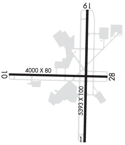
GMU  /  KGMU Airport & FBO Info       GREENVILLE DOWNTOWN     GREENVILLE SC
FltPlan.com
Airport/FBO Info
  Tutorial    Disclaimer    E-Mail Support
Using the 3 or 4 Letter Airport ID:

Printout Size
Full
Compact
 OR
Using the Airport or City Name:  
Minimum 4 letters
Do not use the state in search.

 Airport / FBO Information  
GMU       GREENVILLE DOWNTOWN       GREENVILLE       SC
  Time Zone: ET 
Lat: N 3450.9     Long: W 08221.0     Elev: 1048     Var: +05  Longest Runway: 5393
    AWOS: 127.07   Ground: 121.25     Tower: 119.9

FBO info for KGMU:      
Avgas and Jet-A Fuel, Full Service Maintenance, Pilots' Lounge with High Speed Wireless Internet Access, Customer Lounge, Complimentary Crew Cars, Rental Cars, Conference Room, Catering, Complimentary Coffee and Ice, Overnight and Extended Stay Hangar Space and Tie-down, Professional Line Service, Quick Turn Service, Plasma TV with ASD, GPU, Lav Service, Flight Planning Room, Shuttle Van
Ph: 800-388-9380   website E-Mail TAC Air Fax: 864-370-2939 Freq: 129.87
GREENVILLE JET CT Ph: 800-452-0379 Fax: 864-235-6384 Freq: 122.95
AWOS Ph: 864-239-0014
-
Freq: 127.07


FBO's at nearby airports who want your business:

 Runway & Approach Info
  Rwy  
    Length    
  Land Dist Avail  
  Approach*  
    Rwy  
Length
  Land Dist Avail  
 Approach* 
01
5393x100  5393'          
ILS
 109.70 - 006º  
  
19
  5393x100  5393'          
 
10
3998x80  3733'          
 
  
28
  3998x80  3728'          
 
 * only ILS, LOC, LDA, and SDF approaches to a specific runway are shown

Runway Weight Capability   (lbs.)
Runway IDSingle WheelDouble WheelDouble Tandem WheelDual Double Wheel
01/1944,00060,00095,000N/A
10/2820,000N/AN/AN/A
H120,000N/AN/AN/A
H220,000N/AN/AN/A


Database effective date: 06/05/2008

Airport Diagram might not be current.
Airport Diagram of KGMU
Facility Name: GREENVILLE DOWNTOWN
City Name: GREENVILLE
County: GREENVILLE
State abbrev: SC
State Name: SOUTH CAROLINA
   
Ownership: PUBLICLY OWNED
Use: OPEN TO THE PUBLIC
Owner's Name: GREENVILLE AIRPORT COMMISSION
Address: 100 TOWER DR, UNIT 2
 GREENVILLE, SC 29607
Owner's Phone: 864-242-4777
  
Manager's Name: JOE FRASHER
Address: 100 TOWER DR, UNIT 2
 GREENVILLE, SC 29607
Phone: 864-242-4777
   
FAA Region: SOUTHERN
FAA Field Office: ATL

Click here to submit your photo
Area Map of GMU
Click Here for Rand McNally Map of GMU

Sunrise / Sunset times for:
GREENVILLE DOWNTOWN
Date: Sunrise Sunset
May 01, 2008 6:3820:15
June 01, 2008 6:1720:38
July 01, 2008 6:2020:47
August 01, 2008 6:4020:31
September 01, 2008 7:0319:55
October 01, 2008 7:2519:12
November 01, 2008 7:5118:35
December 01, 2008 7:1917:18
January 01, 2009 7:3717:29
February 01, 2009 7:2817:58
March 01, 2009 6:5918:25
April 01, 2009 7:1719:51

 Airport Facilities
Airport Attendance Schedule: SAT-SUN 0600-1100, MON-FRI 0500-2200
Airport Status: OPERATIONAL (This Status can change at any time - please check NOTAMS)
Airport Lighting Schedule: DUSK-DAWN; WHEN ATCT CLSD ACTVT HIRL RY 01/19, REIL RYS 01 & 19 AND PERIMETER LGTS H1 & H2 - CTAF.
Airport Storage Available: Tie Downs, Hanger
Extra Services Available: Air Freight, Cargo Handling, Charter, Flight Instruction, Aircraft Rental, Annual SurveyingFlight Instruction, Aircraft RentalAir Ambulance, Avionics, Cargo Handling, Charter, Flight Instruction, Aircraft Rental, Aircraft Sales, Annual Surveying
Wind Indicator: YES - (lighted)
Control Tower: YES
CTAF Frequency: 119.900
Unicom Frequency: 122.950
Rotating Beacon Color: CLEAR-GREEN (Light Land Airport)
Segmented Circle: YES
Landing Fee: NO

Airport Services
Type of Fuel Available: Grade 100LL, JET A (freeze point -40C)
Airframe Repair Service: MAJOR
Power Plant Repair Service: MAJOR

Geographic Data
Latitude: N3450.9   Longitude: W08221.0  (ESTIMATED)
Arpt Elevation: 1048ft (SURVEYED)
Magnetic Variation: 05W
3 miles E of GREENVILLE
Traffic Pattern Altitude: TPA 800 AGL FOR LIGHT ACFT, 1000 AGL FOR HEAVY ACFT.
Sectional Chart: ATLANTA

  Aircraft Data
Operations (reported)
YearlyAvg. Daily
General Aviation transient: 2933380
General Aviation Local: 1888952
Air Taxi: 2499768
Commercial: 00
Commuter: 00
Military: 30418
Aircraft based on Field
General Aviation Singles: 168
General Aviation Multi: 60
Jet Aircraft: 16
General Aviation Helicopters: 6
Military Aircraft: 0
Gliders: 0
Ultralights: 0

  FAA Services
FSS on field: NO
FSS tie-in: ANDERSON
FSS Phone: 1-800-WX-BRIEF
Who issues Notams: GMU
Notam D service at airport: YES
ARTCC Name: ATLANTA
 
  Federal Status
Airport Certification:
Aircraft Rescue & Firefighting Index: None
Airport of Entry: No
Custom Landing Rights: No
Joint Civil/Military: No
Military Landing rights: YES

Runway Identification: 01/19
Length: 5393 ft
Width: 100 ft
Surface: ASPHALT-GOOD CONDITION
Edge lights: High Intensity

Treatment: GROOVED


Runway: 01
 
Runway: 19
Mag heading:  6ºMag heading:  186º
Rwy Slope:  1.10% UpRwy Slope:  -1.10% Down
Approach:  ILSApproach:  
Pattern:  Left TrafficPattern:  Right Traffic
Markings:  PRECISION INSTRUMENTMarkings:  PRECISION INSTRUMENT
Marking Condition:  GOODMarking Condition:  GOOD
Arresting Dev:  Arresting Dev:  
Lat & Long:  N3450.4  W08220.9Lat. & Long.:  N3451.3  W08220.9
Elev:  988.2 ft. MSLElev:  1047.5 ft. MSL
TCH:  35 ft. AGLTCH:  30 ft. AGL
Visual Glide Path:  Visual Glide Path:  
Displaced Threshold:  NoDisplaced Threshold:  No
Touchdown Zone:  YESTouchdown Zone:  YES
Touchdown Elev.:  1015 feetTouchdown Elev.:  1048 feet
Visual Glide Slope:  4-Light PAPI on LEFT side of RunwayVisual Glide Slope:  4-Light PAPI on LEFT side of Runway
RVR Equipment:  RVR Equipment:  
RVV Equipment:  NORVV Equipment:  NO
Approach Lights:  MALSF - 1,400 foot medium intensity approach lighting system with sequenced flashersApproach Lights:  
REIL:  YESREIL:  YES
Centerline Lights:  NOCenterline Lights:  NO
Touchdown lights:  NOTouchdown lights:  NO
Runway Catagory:  PRECISION INSTRUMENT RUNWAYRunway Catagory:  OTHER THAN UTILITY RUNWAY WITH A VISUAL APPROACH
Obstructions:  TREEObstructions:  TREE
Marked:  NOT Marked/LightedMarked:  NOT Marked/Lighted
Clearance slope:  4:1Clearance slope:  19:1
Obstruction height:  10 feet AGLObstruction height:  100 feet AGL
Dist. from runway:  250 feetDist. from runway:  2158 feet
Centerline offset:  92 left of centerlineCenterline offset:  312 feet left of centerline
Comments:  Comments:  

Runway Identification: 10/28
Length: 3998 ft
Width: 80 ft
Surface: ASPHALT-GOOD CONDITION
Edge lights: Medium Intensity


Runway: 10
 
Runway: 28
Mag heading:  96ºMag heading:  276º
Rwy Slope:  .51% UpRwy Slope:  -.51% Down
Approach:  Approach:  
Pattern:  Left TrafficPattern:  Right Traffic
Markings:  BASICMarkings:  BASIC
Marking Condition:  GOOD; MARKINGS FADED.Marking Condition:  GOOD; MARKINGS FADED.
Arresting Dev:  Arresting Dev:  
Lat & Long:  N3450.9  W08221.5Lat. & Long.:  N3450.9  W08220.7
Elev:  994.1 ft. MSLElev:  1014.4 ft. MSL
TCH:  TCH:  40 ft. AGL
Visual Glide Path:  Visual Glide Path:  3.00 degrees
Displaced Threshold:  265 feetDisplaced Threshold:  270 feet
Touchdown Zone:  YESTouchdown Zone:  YES
Touchdown Elev.:  1013 feetTouchdown Elev.:  1013 feet
Visual Glide Slope:  Visual Glide Slope:  2-Light PAPI on LEFT side of Runway
RVR Equipment:  RVR Equipment:  
RVV Equipment:  NORVV Equipment:  NO
Approach Lights:  Approach Lights:  
REIL:  NOREIL:  YES
Centerline Lights:  NOCenterline Lights:  NO
Touchdown lights:  NOTouchdown lights:  NO
Runway Catagory:  Utility Runway with a Visual ApproachRunway Catagory:  Utility Runway with a Visual Approach
Obstructions:  TREEObstructions:  TREE
Marked:  NOT Marked/LightedMarked:  NOT Marked/Lighted
Clearance slope:  14:1; RY 10 APCH IS 20:1 AT DSPLCD THLD.Clearance slope:  6:1; RY 28 APCH IS 20:1 AT DSPLCD THLD.
Obstruction height:  56 feet AGLObstruction height:  20 feet AGL
Dist. from runway:  1002 feetDist. from runway:  327 feet
Centerline offset:  226 left of centerlineCenterline offset:  92 feet left of centerline
Comments:  Comments:  

Runway Identification: H1 HELIPAD
Length: 50 ft
Width: 50 ft
Surface: CONCRETE-GOOD CONDITION
Edge lights: PERI


Runway Identification: H2 HELIPAD
Length: 50 ft
Width: 50 ft
Surface: CONCRETE-GOOD CONDITION
Edge lights: PERI


Remarks
  • THIS AIRPORT HAS BEEN SURVEYED BY THE NATIONAL GEODETIC SURVEY.
  • ACFT OPER IN THE GREENVILLE ARPT TFC AREA S THRU E BE ALERT FOR JET & CONVENTIONAL TFC DES ON THE GREENVILLE-SPARTANBURG LOC COURSE.
  • ACFT INBD FROM THE SSW OR ON ILS RY 01 APCH BE ALERT FOR TFC 4.5 MI S OPERG IN THE DONALDSON CENTER ARPT TFC PAT AT 1800 FT OR BLO.
  • NO OVERNIGHT PARKING ON HELIPADS.
  • NO ACFT PERMITTED ON TWYS 'C' OR 'D' WHEN ACFT GREATER THAN 12,500 LBS IS OPERATING ON RY 10/28.
  • RY 10/28 RESTRICTED TO ACFT LESS THAN 12,500 LBS WHEN ACFT GREATER THAN 12,500 LBS IS OPERATING ON TWYS 'C' OR 'D'.
  • 157 FT BY 113 FT ENGINEERED MATERIAL ARRESTING SYSTEM AT THE END OF RY 19 (DEP END OF RY 01).
  • RWY 10 RY 10 SLOPE 0.5% UP EAST.
  • RWY 28 RY 28 SLOPE 0.5% DOWN WEST.

  • Federal Agreements
  • NATIONAL PLAN OF INTEGRATED AIRPORT SYSTEMS (NPIAS)
  • GRANT AGREEMENTS UNDER FAAP/ADAP/AIP
  • ASSURANCES PURSUANT TO TITLE VI, CIVIL RIGHTS ACT OF 1964
  • AGREEMENT UNDER DLAND OR DCLA HAS EXPIRED.

  • Airport Inspection Data
    Airport Inspected:: STATE - performed by STATE AERONAUTICAL PERSONNEL
    Inspection Date: 08/28/2007


    Airport Communications & Frequencies:
    GREENVILLE Tower Frequencies:   Hours(local) of operation: 0700-2200   
    119.9
    257.7
    GREENVILLE Ground Frequencies:
    121.25
    CTAF Frequency: 119.900
    Unicom Frequency: 122.950

    Remarks
  • APCH/DEP SVC PRVDD BY ATLANTA ARTCC ON FREQS 135.35/322.4 (OWING RCAG) WHEN GREER APCH CTL CLSD.

  • GREER Primary Approach Frequencies:  
    118.8
    385.4
    GREER Primary Departure Frequencies:  
    118.8
    385.4