
| GAYLORD RGNL GAYLORD MI |
| |
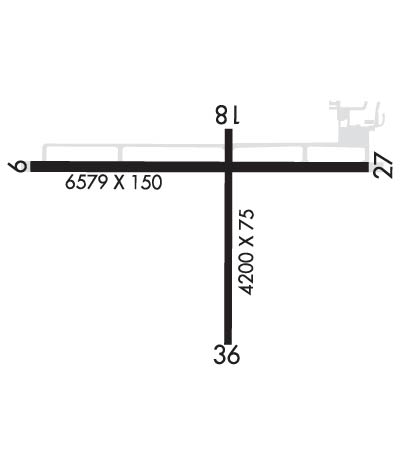
| Lat: N 4500.8 Long: W 08442.2 Elev: 1328 Var: +06 Longest Runway: 6579 | ||
| AWOS: 118.37 CTAF: 122.8 | ||
| ||||||
| ||||||
|
| Rwy | Rwy | |||||||
| 6579x150 | 6579' | 111.10 - 096° | 6579x150 | 6579' | ||||
| 4200x75 | 4200' | 4200x75 | 4200' | |||||
| Runway ID | Single Wheel | Double Wheel | Double Tandem Wheel | Dual Double Wheel |
| 09/27 | N/A | 100,000 | N/A | N/A |
| 18/36 | 12,500 | N/A | N/A | N/A |
| These numbers are Advisory and are not limits. The Airport Manager should have more accurate Weight Limits | ||||
 Airport Diagram might not be current. | |
| Facility Name: | GAYLORD RGNL |
| City Name: | GAYLORD |
| County: | OTSEGO |
| State abbrev: | MI |
| State Name: | MICHIGAN |
| Ownership: | PUBLICLY OWNED |
| Use: | OPEN TO THE PUBLIC |
| Owner's Name: | OTSEGO COUNTY |
| Address: | 225 W MAIN ST |
| GAYLORD, MI 49735-1881 | |
| Owner's Phone: | 989-731-7520 |
| Manager's Name: | MATT BARRESI |
| Address: | PO BOX 1396 |
| GAYLORD, MI 49734-5396 | |
| Phone: | 989-732-4218; CELL 989-370-9484. |
| FAA Region: | GREAT LAKES |
| FAA Field Office: | DET |
| Date | Sunrise | Sunset |
|---|---|---|
| 09/24/21 Friday | 7:28 | 19:33 |
| 09/25/21 Saturday | 7:29 | 19:31 |
| 09/26/21 Sunday | 7:30 | 19:29 |
| 09/27/21 Monday | 7:32 | 19:27 |
| 09/28/21 Tuesday | 7:33 | 19:25 |
| 09/29/21 Wednesday | 7:34 | 19:23 |
| 09/30/21 Thursday | 7:35 | 19:22 |
| 10/01/21 Friday | 7:37 | 19:20 |
| 10/02/21 Saturday | 7:38 | 19:18 |
| 10/03/21 Sunday | 7:39 | 19:16 |
| 10/04/21 Monday | 7:40 | 19:14 |
| 10/05/21 Tuesday | 7:41 | 19:12 |
| 10/06/21 Wednesday | 7:43 | 19:10 |
| 10/07/21 Thursday | 7:44 | 19:09 |
| Airport Attendance Schedule | MAY-OCT 7 Days A Week 0730-1800, NOV-APR 7 Days A Week 0630-1700; FOR ATTENDANT AFT HRS CALL AMGR. UNATNDD THANKSGIVING, CHRISTMAS, & NEW YEARS DAY. |
| Airport Status | OPERATIONAL (This Status can change at any time - please check NOTAMS) |
| Airport Lighting Schedule | ACTVT MALSR RWY 09; REIL RWY 27, 18, & 36; PAPI RWY 09, 27, 18, & 36; HIRL RWY 09/27; MIRL RWY 18/36 - CTAF. |
| Airport Storage Available | Tie Downs, Hanger |
| Extra Services Available | Cargo Handling, Charter |
| Wind Indicator | YES - (lighted) |
| Control Tower | NO |
| CTAF Frequency | 122.800 |
| Unicom Frequency | 122.800 |
| Rotating Beacon Color | CLEAR-GREEN (Light Land Airport) |
| Segmented Circle | YES |
| Landing Fee | NO; LDG FEE FOR TURBINE, JET, & TWIN-ENG ACFT WAIVED WITH MNM FUEL PURCHASE. OVNGT PRKG FEE. |
| Airport Inspected | FEDERAL - performed by STATE AERONAUTICAL PERSONNEL |
| Inspection Date | 04/14/2021 |
| Type of Fuel Available | Grade 100LL, JET A; -10SUBJ AFT HRS CALL-IN FEE. |
| Airframe Repair Service | MAJOR |
| Power Plant Repair Service | MAJOR |
| Latitude | N4500.8 |
| Longitude | W08442.2 (ESTIMATED) |
| Arpt Elevation | 1328ft (SURVEYED) |
| Magnetic Variation | 06W |
| 1 miles SW | of GAYLORD |
| Traffic Pattern Altitude | |
| Sectional Chart | LAKE HURON |
| Operations (Reported) | Yearly | Avg. Daily |
|---|---|---|
| General Aviation Transient | 8000 | 22 |
| General Aviation Local | 2000 | 5 |
| Air Taxi | 0 | 0 |
| Commerical | 0 | 0 |
| Commuter | 0 | 0 |
| Military | 0 | 0 |
| Aircraft based on Field | |
|---|---|
| General Aviation Singles | 16 |
| General Aviation Multi | 7 |
| Jet Aircraft | 1 |
| General Aviation Helicopters | 1 |
| Military Aircraft | 0 |
| Gliders | 0 |
| Ultralights | 0 |
| FSS on field | NO |
| FSS tie-in | LANSING |
| FSS Phone | 1-800-WX-BRIEF |
| Who issues Notams | GLR |
| Notam D service at airport | YES |
| ARTCC Name | MINNEAPOLIS |
| Airport Certification | |
| Aircraft Rescue & Firefighting Index | None |
| Airport of Entry | No |
| Custom Landing Rights | No |
| Joint Civil/Military | No |
| Military Landing rights | YES |
| NATIONAL PLAN OF INTEGRATED AIRPORT SYSTEMS (NPIAS) |
| GRANT AGREEMENTS UNDER FAAP/ADAP/AIP |
| ASSURANCES PURSUANT TO TITLE VI, CIVIL RIGHTS ACT OF 1964 |
| DEER & BIRDS ON & INVOF ARPT. |
| MIL TRG ACT INVOF ARPT ASSOCD WITH R-4201A/B. |
| ADMIN BLDG ACES 5-3-2-1. |
| FOR CD IF UNA TO CTC ON FSS FREQ, CTC MINNEAPOLIS ARTCC AT 651-463-5588. |
Airport Communications & Frequencies:
| |||||||||
| Runway: 09 | Runway: 27 | ||
| Mag heading: | 96° | Mag heading: | 276° |
| Rwy Slope: | .11% Up | Rwy Slope: | -.11% Down |
| Approach: | ILS | Approach: | |
| Pattern: | Left Traffic | Pattern: | Left Traffic |
| Markings: | PRECISION INSTRUMENT | Markings: | PRECISION INSTRUMENT |
| Marking Condition: | FAIR | Marking Condition: | FAIR |
| Arresting Dev: | Arresting Dev: | ||
| Lat & Long: | N4500.9 W08443.0 | Lat. & Long.: | N4500.9 W08441.5 |
| Elev: | 1320.6 ft. MSL | Elev: | 1328.1 ft. MSL |
| TCH: | 38 ft. AGL | TCH: | 45 ft. AGL |
| Visual Glide Path: | 3.00 degrees | Visual Glide Path: | 3.00 degrees |
| Displaced Threshold: | No | Displaced Threshold: | No |
| Touchdown Zone: | YES | Touchdown Zone: | YES |
| Touchdown Elev.: | 1320.6 feet | Touchdown Elev.: | 1328.1 feet |
| Visual Glide Slope: | 4-Light PAPI on LEFT side of Runway | Visual Glide Slope: | 4-Light PAPI on LEFT side of Runway |
| RVR Equipment: | RVR Equipment: | ||
| RVV Equipment: | NO | RVV Equipment: | NO |
| Approach Lights: | MALSR - 1,400 foot medium intensity approach lighting system with runway alignment indicator lights | Approach Lights: | |
| REIL: | NO | REIL: | YES |
| Centerline Lights: | NO | Centerline Lights: | NO |
| Touchdown lights: | NO | Touchdown lights: | NO |
| Runway Category: | Precision Instrument Runway | Runway Category: | Runway with a Non-precision Approach having visibility minimums greater than 3/4 mile |
| Declared Distances: | Declared Distances: | ||
| Obstructions: | TREES | Obstructions: | POLE |
| Marked: | NOT Marked/Lighted | Marked: | NOT Marked/Lighted |
| Clearance slope: | 44:1 | Clearance slope: | 24:1 |
| Obstruction height: | 21 feet AGL | Obstruction height: | 37 feet AGL |
| Dist. from runway: | 1130 feet | Dist. from runway: | 1109 feet |
| Centerline offset: | 579 left of centerline | Centerline offset: | 511 feet right of centerline |
| Comments: | Comments: |
| Runway: 18 | Runway: 36 | ||
| Mag heading: | 186° | Mag heading: | 6° |
| Rwy Slope: | -.13% Down | Rwy Slope: | .13% Up |
| Approach: | Approach: | ||
| Pattern: | Left Traffic | Pattern: | Left Traffic |
| Markings: | PRECISION INSTRUMENT | Markings: | PRECISION INSTRUMENT |
| Marking Condition: | FAIR | Marking Condition: | FAIR |
| Arresting Dev: | Arresting Dev: | ||
| Lat & Long: | N4501.0 W08442.1 | Lat. & Long.: | N4500.3 W08442.1 |
| Elev: | 1321.9 ft. MSL | Elev: | 1316.4 ft. MSL |
| TCH: | 40 ft. AGL | TCH: | 40 ft. AGL |
| Visual Glide Path: | 3.00 degrees | Visual Glide Path: | 3.00 degrees |
| Displaced Threshold: | No | Displaced Threshold: | No |
| Touchdown Zone: | YES | Touchdown Zone: | YES |
| Touchdown Elev.: | 1321.9 feet | Touchdown Elev.: | 1320.9 feet |
| Visual Glide Slope: | 4-Light PAPI on LEFT side of Runway | Visual Glide Slope: | 4-Light PAPI on LEFT side of Runway; PAPI UNUSBL BYD 8 DEGS LEFT & 7 DEGS RIGHT OF CNTRLN. |
| RVR Equipment: | RVR Equipment: | ||
| RVV Equipment: | NO | RVV Equipment: | NO |
| Approach Lights: | Approach Lights: | ||
| REIL: | YES | REIL: | YES |
| Centerline Lights: | NO | Centerline Lights: | NO |
| Touchdown lights: | NO | Touchdown lights: | NO |
| Runway Category: | Runway with a Visual Approach | Runway Category: | Runway with a Visual Approach |
| Declared Distances: | Declared Distances: |
Thanks for using FltPlan.com
all rights reserved © 1999-2021 by Flight Plan LLC