
| MID DELTA RGNL GREENVILLE MS |
| |
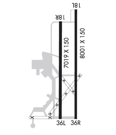
| Lat: N 3329.0 Long: W 09059.1 Elev: 131 Var: -03 Longest Runway: 8001 | ||
| AWOS: 125.52 Ground: 121.8 Tower: 119.0 | ||
| ||||||
| ||||||
|
| Rwy | Rwy | |||||||
| 8001x150 | 8001' | 109.10 - 177° | 8001x150 | 8001' | ||||
| 7019x150 | 7019' | 7019x150 | 7019' | |||||
| Runway ID | Single Wheel | Double Wheel | Double Tandem Wheel | Dual Double Wheel |
| 18L/36R | 75,000 | 112,000 | 182,000 | 540,000 |
| 18R/36L | 29,000 | 47,000 | 78,000 | N/A |
| These numbers are Advisory and are not limits. The Airport Manager should have more accurate Weight Limits | ||||
 Airport Diagram might not be current. | |
| Facility Name: | GREENVILLE MID-DELTA |
| City Name: | GREENVILLE |
| County: | WASHINGTON |
| State abbrev: | MS |
| State Name: | MISSISSIPPI |
| Ownership: | PUBLICLY OWNED |
| Use: | OPEN TO THE PUBLIC |
| Owner's Name: | CITY OF GREENVILLE |
| Address: | 340 MAIN STREET |
| GREENVILLE, MS 38701 | |
| Owner's Phone: | |
| Manager's Name: | SAM WASHINGTON |
| Address: | 166 FIFTH AVE SUITE 300 |
| GREENVILLE, MS 38703 | |
| Phone: | 662-334-3121 |
| FAA Region: | SOUTHERN |
| FAA Field Office: | JAN |
| Date | Sunrise | Sunset |
|---|---|---|
| 09/24/21 Friday | 6:53 | 18:58 |
| 09/25/21 Saturday | 6:54 | 18:57 |
| 09/26/21 Sunday | 6:55 | 18:55 |
| 09/27/21 Monday | 6:55 | 18:54 |
| 09/28/21 Tuesday | 6:56 | 18:53 |
| 09/29/21 Wednesday | 6:57 | 18:51 |
| 09/30/21 Thursday | 6:57 | 18:50 |
| 10/01/21 Friday | 6:58 | 18:49 |
| 10/02/21 Saturday | 6:59 | 18:47 |
| 10/03/21 Sunday | 7:00 | 18:46 |
| 10/04/21 Monday | 7:00 | 18:45 |
| 10/05/21 Tuesday | 7:01 | 18:43 |
| 10/06/21 Wednesday | 7:02 | 18:42 |
| 10/07/21 Thursday | 7:02 | 18:41 |
| Airport Attendance Schedule | 7 Days A Week 0700-1900 |
| Airport Status | OPERATIONAL (This Status can change at any time - please check NOTAMS) |
| Airport Lighting Schedule | WHEN ATCT CLSD ACTVT MALSR RWY 18L; HIRL RWY 18L/36R PRESET MED INTST TO INCR INTST - CTAF. PAPI RWY 36R OPR CONSLY. |
| Airport Storage Available | Tie Downs, Hanger |
| Extra Services Available | Cargo Handling, Flight Instruction |
| Wind Indicator | YES - (lighted) |
| Control Tower | YES |
| CTAF Frequency | 119.000 |
| Unicom Frequency | 122.950 |
| Rotating Beacon Color | CLEAR-GREEN (Light Land Airport) |
| Segmented Circle | YES |
| Landing Fee | NO |
| Airport Inspected | FEDERAL - performed by FAA AIRPORTS FIELD PERSONNEL |
| Inspection Date | 08/30/2019 |
| Type of Fuel Available | Grade 100LL, JET A (freeze point -40C) |
| Airframe Repair Service | MAJOR |
| Power Plant Repair Service | MAJOR |
| Latitude | N3329.0 |
| Longitude | W09059.1 (ESTIMATED) |
| Arpt Elevation | 130ft (SURVEYED) |
| Magnetic Variation | 03E |
| 5 miles NE | of GREENVILLE |
| Traffic Pattern Altitude | |
| Sectional Chart | MEMPHIS |
| Operations (Reported) | Yearly | Avg. Daily |
|---|---|---|
| General Aviation Transient | 13767 | 38 |
| General Aviation Local | 1284 | 4 |
| Air Taxi | 1389 | 4 |
| Commerical | 10 | 0 |
| Commuter | 0 | 0 |
| Military | 6524 | 18 |
| Aircraft based on Field | |
|---|---|
| General Aviation Singles | 9 |
| General Aviation Multi | 1 |
| Jet Aircraft | 1 |
| General Aviation Helicopters | 0 |
| Military Aircraft | 0 |
| Gliders | 0 |
| Ultralights | 0 |
| FSS on field | NO |
| FSS tie-in | GREENWOOD |
| FSS Phone | 1-800-WX-BRIEF |
| Who issues Notams | GLH |
| Notam D service at airport | YES |
| ARTCC Name | MEMPHIS |
| Airport Certification | |
| Aircraft Rescue & Firefighting Index | INDEX A ARFF EQUIP AVBL UPON REQ ONLY. CLSD TO UNSCHED ACR OPS WITH MORE THAN 30 PSGR SEATS. |
| Airport of Entry | No |
| Custom Landing Rights | No |
| Joint Civil/Military | No |
| Military Landing rights | YES |
| NATIONAL PLAN OF INTEGRATED AIRPORT SYSTEMS (NPIAS) |
| GRANT AGREEMENTS UNDER FAAP/ADAP/AIP |
| SURPLUS PROPERTY AGREEMENT UNDER PUBLIC LAW 289 |
| ASSURANCES PURSUANT TO TITLE VI, CIVIL RIGHTS ACT OF 1964 |
| AGREEMENT UNDER DLAND OR DCLA HAS EXPIRED. |
| THIS AIRPORT HAS BEEN SURVEYED BY THE NATIONAL GEODETIC SURVEY. |
| TWY C, D, AND F NOT AVBL FOR ACR USE. |
| FOR CD CTC MEMPHIS ARTCC AT 901-368-8453/8449. |
| INDEX A ARFF EQUIP AVBL UPON REQ ONLY. CLSD TO UNSCHED ACR OPS WITH MORE THAN 30 PSGR SEATS. |
| RWY 18R/ 36LNO TKF OR LNDG AUTH FOR ACR ACFT. |
| RWY 18R/ 36LUNEVEN PAVEMENT |
Airport Communications & Frequencies:
| |||||||||||||||||||||
| Runway: 18L | Runway: 36R | ||
| Mag heading: | 177° | Mag heading: | 357° |
| Rwy Slope: | .00% Up | Rwy Slope: | .00% Down |
| Approach: | ILS | Approach: | |
| Pattern: | Left Traffic | Pattern: | Right Traffic |
| Markings: | PRECISION INSTRUMENT | Markings: | PRECISION INSTRUMENT |
| Marking Condition: | FAIR | Marking Condition: | FAIR |
| Arresting Dev: | Arresting Dev: | ||
| Lat & Long: | N3329.8 W09058.9 | Lat. & Long.: | N3328.5 W09058.9 |
| Elev: | 129.2 ft. MSL | Elev: | 129.4 ft. MSL |
| TCH: | TCH: | 60 ft. AGL | |
| Visual Glide Path: | Visual Glide Path: | 3.00 degrees | |
| Displaced Threshold: | No | Displaced Threshold: | No |
| Touchdown Zone: | YES | Touchdown Zone: | YES |
| Touchdown Elev.: | 129.2 feet | Touchdown Elev.: | 129.4 feet |
| Visual Glide Slope: | Visual Glide Slope: | 4-Light PAPI on LEFT side of Runway | |
| RVR Equipment: | RVR Equipment: | ||
| RVV Equipment: | NO | RVV Equipment: | NO |
| Approach Lights: | MALSR - 1,400 foot medium intensity approach lighting system with runway alignment indicator lights | Approach Lights: | |
| REIL: | NO | REIL: | YES |
| Centerline Lights: | NO | Centerline Lights: | NO |
| Touchdown lights: | NO | Touchdown lights: | NO |
| Runway Category: | Precision Instrument Runway | Runway Category: | Runway with a Non-precision Approach having visibility minimums greater than 3/4 mile |
| Declared Distances: | TORA:8001' TODA:8001' ASDA:7981' LDA:7981' | Declared Distances: | TORA:8001' TODA:8001' ASDA:8001' LDA:8001' |
| Obstructions: | Obstructions: | TREE | |
| Marked: | Marked: | NOT Marked/Lighted | |
| Clearance slope: | 50:1 | Clearance slope: | 41:1 |
| Obstruction height: | Obstruction height: | 84 feet AGL | |
| Dist. from runway: | Dist. from runway: | 3691 feet | |
| Centerline offset: | Centerline offset: | 478 feet left of centerline | |
| Comments: | Comments: |
| Runway: 18R | Runway: 36L | ||
| Mag heading: | 177° | Mag heading: | 357° |
| Rwy Slope: | .02% Up | Rwy Slope: | -.02% Down |
| Approach: | Approach: | ||
| Pattern: | Right Traffic | Pattern: | Left Traffic |
| Markings: | NONPRECISION INSTRUMENT | Markings: | NONPRECISION INSTRUMENT |
| Marking Condition: | POOR; MARKINGS FADED. | Marking Condition: | POOR; MARKINGS FADED. |
| Arresting Dev: | Arresting Dev: | ||
| Lat & Long: | N3329.7 W09059.2 | Lat. & Long.: | N3328.5 W09059.2 |
| Elev: | 128.4 ft. MSL | Elev: | 130.0 ft. MSL |
| TCH: | 52 ft. AGL | TCH: | 52 ft. AGL |
| Visual Glide Path: | 3.00 degrees | Visual Glide Path: | 3.00 degrees |
| Displaced Threshold: | No | Displaced Threshold: | No |
| Touchdown Zone: | YES | Touchdown Zone: | YES |
| Touchdown Elev.: | 128.4 feet | Touchdown Elev.: | 130.0 feet |
| Visual Glide Slope: | 4-Light PAPI on LEFT side of Runway | Visual Glide Slope: | 4-Light PAPI on LEFT side of Runway |
| RVR Equipment: | RVR Equipment: | ||
| RVV Equipment: | NO | RVV Equipment: | NO |
| Approach Lights: | Approach Lights: | ||
| REIL: | NO | REIL: | NO |
| Centerline Lights: | NO | Centerline Lights: | NO |
| Touchdown lights: | NO | Touchdown lights: | NO |
| Runway Category: | Runway with a Non-precision Approach having visibility minimums greater than 3/4 mile | Runway Category: | Runway with a Non-precision Approach having visibility minimums greater than 3/4 mile |
| Declared Distances: | Declared Distances: | ||
| Obstructions: | Obstructions: | TREES | |
| Marked: | Marked: | NOT Marked/Lighted | |
| Clearance slope: | 50:1 | Clearance slope: | 21:1 |
| Obstruction height: | Obstruction height: | 56 feet AGL | |
| Dist. from runway: | Dist. from runway: | 1400 feet | |
| Centerline offset: | Centerline offset: | 425 feet left of centerline | |
| Comments: | Comments: |
Thanks for using FltPlan.com
all rights reserved © 1999-2021 by Flight Plan LLC
