| GAINESVILLE MUNI GAINESVILLE TX |
| |
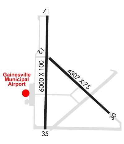
| Lat: N 3339.1 Long: W 09711.8 Elev: 846 Var: -03 Longest Runway: 6000 | ||
| AWOS: 118.37 CTAF: 123.0 | ||
| |||||||||||||||||||||||||||||||||||||||||||||||||||||||||||||||||||||
| |||||||||||||||||||||||||||||||||||||||||||||||||||||||||||||||||||||
| |||||||||||||||||||||||||||||||||||||||||||||||||||||||||||||||||||||
| Rwy | Rwy | |||||||
| 4307x75 | 4307' | 4307x75 | 4307' | |||||
| 6000x100 | 6000' | 6000x100 | 6000' | |||||
| Runway ID | Single Wheel | Double Wheel | Double Tandem Wheel | Dual Double Wheel |
| 13/31 | 15,000 | N/A | N/A | N/A |
| 18/36 | 30,000 | 50,000 | N/A | N/A |
| These numbers are Advisory and are not limits. The Airport Manager should have more accurate Weight Limits | ||||
 Airport Diagram might not be current. | |
| Facility Name: | GAINESVILLE MUNI |
| City Name: | GAINESVILLE |
| County: | COOKE |
| State abbrev: | TX |
| State Name: | TEXAS |
| Ownership: | PUBLICLY OWNED |
| Use: | OPEN TO THE PUBLIC |
| Owner's Name: | CITY OF GAINESVILLE |
| Address: | 200 S. RUSK |
| GAINESVILLE, TX 76240 | |
| Owner's Phone: | 940-668-4500 |
| Manager's Name: | ANDREW HOLLEY |
| Address: | 2300 AIRPORT DR |
| GAINESVILLE, TX 76240 | |
| Phone: | 940-668-4565 |
| FAA Region: | SOUTHWEST |
| FAA Field Office: | TEX |
| Date | Sunrise | Sunset |
|---|---|---|
| 06/07/26 Sunday | 6:18 | 20:37 |
| 06/08/26 Monday | 6:18 | 20:38 |
| 06/09/26 Tuesday | 6:18 | 20:38 |
| 06/10/26 Wednesday | 6:18 | 20:39 |
| 06/11/26 Thursday | 6:18 | 20:39 |
| 06/12/26 Friday | 6:18 | 20:39 |
| 06/13/26 Saturday | 6:18 | 20:40 |
| 06/14/26 Sunday | 6:18 | 20:40 |
| 06/15/26 Monday | 6:18 | 20:41 |
| 06/16/26 Tuesday | 6:18 | 20:41 |
| 06/17/26 Wednesday | 6:18 | 20:41 |
| 06/18/26 Thursday | 6:18 | 20:42 |
| 06/19/26 Friday | 6:18 | 20:42 |
| 06/20/26 Saturday | 6:19 | 20:42 |
| Airport Attendance Schedule | 7 Days A Week 0800-1700 |
| Airport Status | OPERATIONAL (This Status can change at any time - please check NOTAMS) |
| Airport Lighting Schedule | RWY 18/36 MIRL PRESET LOW INTST; TO INCR INTST ACTVT - CTAF. |
| Airport Storage Available | Tie Downs, Hanger |
| Extra Services Available | Crop Dusting, Flight Instruction, Aircraft Rental |
| Wind Indicator | YES - (lighted) |
| Control Tower | NO |
| CTAF Frequency | 123.000 |
| Unicom Frequency | 123.000 |
| Rotating Beacon Color | WG |
| Segmented Circle | YES |
| Landing Fee | NO |
| Airport Inspected | STATE - performed by PRIVATE CONTRACT PERSONNEL |
| Inspection Date | 05/08/2024 |
| Type of Fuel Available | Grade 100LL, JET A; -10100LL SELF-SERVE & FULL SERVE. |
| Airframe Repair Service | MAJOR |
| Power Plant Repair Service | MAJOR |
| Latitude | N3339.1 |
| Longitude | W09711.8 (ESTIMATED) |
| Arpt Elevation | 845ft (SURVEYED) |
| Magnetic Variation | 03E |
| 3 miles W | of GAINESVILLE |
| Traffic Pattern Altitude | |
| Sectional Chart | DALLAS-FT WORTH |
| Operations (Reported) | Yearly | Avg. Daily |
|---|---|---|
| General Aviation Transient | 0 | 0 |
| General Aviation Local | 0 | 0 |
| Air Taxi | 0 | 0 |
| Commerical | 0 | 0 |
| Commuter | 0 | 0 |
| Military | 0 | 0 |
| Aircraft based on Field | |
|---|---|
| General Aviation Singles | 0 |
| General Aviation Multi | 0 |
| Jet Aircraft | 0 |
| General Aviation Helicopters | 0 |
| Military Aircraft | 0 |
| Gliders | 0 |
| Ultralights | 0 |
| FSS on field | NO |
| FSS tie-in | FORT WORTH |
| FSS Phone | 1-800-WX-BRIEF |
| Who issues Notams | GLE |
| Notam D service at airport | YES |
| ARTCC Name | FORT WORTH |
| Airport Certification | |
| Aircraft Rescue & Firefighting Index | None |
| Airport of Entry | No |
| Custom Landing Rights | No |
| Joint Civil/Military | No |
| Military Landing rights | YES |
| NATIONAL PLAN OF INTEGRATED AIRPORT SYSTEMS (NPIAS) |
| GRANT AGREEMENTS UNDER FAAP/ADAP/AIP |
| SURPLUS PROPERTY AGREEMENT UNDER PUBLIC LAW 289 |
| ASSURANCES PURSUANT TO TITLE VI, CIVIL RIGHTS ACT OF 1964 |
| FOR CD CTC FORT WORTH ARTCC AT 817-858-7584. |
| HEL SKID LDG PROHIBITED ON ALL ASPH SFCS. |
| RWY 13/3 1 EXTSV CRACKING. |
| RWY 13 1 RWY HAS AIM POINTS. |
Airport Communications & Frequencies:
| |||||||||
| Runway: 13 | Runway: 31 | ||
| Mag heading: | 130° | Mag heading: | 310° |
| Rwy Slope: | -.79% Down | Rwy Slope: | .79% Up |
| Approach: | Approach: | ||
| Pattern: | Left Traffic | Pattern: | Left Traffic |
| Markings: | BASIC | Markings: | BASIC |
| Marking Condition: | POOR; MRKGS FADED. | Marking Condition: | POOR; MRKGS FADED. |
| Arresting Dev: | Arresting Dev: | ||
| Lat & Long: | N3339.3 W09711.9 | Lat. & Long.: | N3338.8 W09711.3 |
| Elev: | 826.3 ft. MSL | Elev: | 792.2 ft. MSL |
| TCH: | TCH: | ||
| Visual Glide Path: | Visual Glide Path: | ||
| Displaced Threshold: | No | Displaced Threshold: | No |
| Touchdown Zone: | YES | Touchdown Zone: | YES |
| Touchdown Elev.: | 826.3 feet | Touchdown Elev.: | 817.7 feet |
| Visual Glide Slope: | Visual Glide Slope: | ||
| RVR Equipment: | RVR Equipment: | ||
| RVV Equipment: | NO | RVV Equipment: | NO |
| Approach Lights: | Approach Lights: | ||
| REIL: | NO | REIL: | NO |
| Centerline Lights: | NO | Centerline Lights: | NO |
| Touchdown lights: | NO | Touchdown lights: | NO |
| Runway Category: | Runway with a Visual Approach | Runway Category: | Runway with a Visual Approach |
| Declared Distances: | Declared Distances: | ||
| Obstructions: | TREES | Obstructions: | TREES |
| Marked: | NOT Marked/Lighted | Marked: | NOT Marked/Lighted |
| Clearance slope: | 24:1 | Clearance slope: | 20:1 |
| Obstruction height: | 70 feet AGL | Obstruction height: | 22 feet AGL |
| Dist. from runway: | 1900 feet | Dist. from runway: | 650 feet |
| Centerline offset: | 275 right of centerline | Centerline offset: | 135 feet right of centerline |
| Comments: | Comments: |
| Runway: 18 | Runway: 36 | ||
| Mag heading: | 178° | Mag heading: | 358° |
| Rwy Slope: | -.88% Down | Rwy Slope: | .88% Up |
| Approach: | Approach: | ||
| Pattern: | Left Traffic | Pattern: | Left Traffic |
| Markings: | NONPRECISION INSTRUMENT | Markings: | NONPRECISION INSTRUMENT |
| Marking Condition: | GOOD | Marking Condition: | GOOD |
| Arresting Dev: | Arresting Dev: | ||
| Lat & Long: | N3339.7 W09712.0 | Lat. & Long.: | N3338.7 W09712.0 |
| Elev: | 845.4 ft. MSL | Elev: | 792.4 ft. MSL |
| TCH: | 45 ft. AGL | TCH: | 45 ft. AGL |
| Visual Glide Path: | 3.00 degrees | Visual Glide Path: | 3.00 degrees |
| Displaced Threshold: | No | Displaced Threshold: | No |
| Touchdown Zone: | YES | Touchdown Zone: | YES |
| Touchdown Elev.: | 845.5 feet | Touchdown Elev.: | 818.3 feet |
| Visual Glide Slope: | 2-Light PAPI on RIGHT side of Runway | Visual Glide Slope: | 2-Light PAPI on LEFT side of Runway |
| RVR Equipment: | RVR Equipment: | ||
| RVV Equipment: | NO | RVV Equipment: | NO |
| Approach Lights: | Approach Lights: | ||
| REIL: | YES | REIL: | YES |
| Centerline Lights: | NO | Centerline Lights: | NO |
| Touchdown lights: | NO | Touchdown lights: | NO |
| Runway Category: | Runway with a Non-precision Approach having visibility minimums greater than 3/4 mile | Runway Category: | Runway with a Visual Approach |
| Declared Distances: | Declared Distances: | ||
| Obstructions: | TREES; ALSO 32 FT PLINE, 1290 FT DSTC, 445 L/R. APCH SLOPE 34:1. | Obstructions: | TREES |
| Marked: | NOT Marked/Lighted | Marked: | NOT Marked/Lighted |
| Clearance slope: | 25:1 | Clearance slope: | 38:1 |
| Obstruction height: | 45 feet AGL | Obstruction height: | 35 feet AGL |
| Dist. from runway: | 1325 feet | Dist. from runway: | 1555 feet |
| Centerline offset: | 285 right of centerline | Centerline offset: | |
| Comments: | Comments: |
Thanks for using FltPlan.com
all rights reserved © 1999-2026 by Flight Plan LLC