
| GRAND JUNCTION REGIONAL GRAND JUNCTION CO |
| |
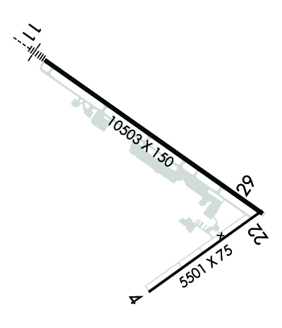
| Lat: N 3907.3 Long: W 10831.5 Elev: 4861 Var: -09 Longest Runway: 9339 | ||
| Dept. ATIS: 118.55 Arr. ATIS: 118.55 Ground: 121.7 Tower: 118.1 | ||
| ||||||||||||||||||||||||||||||||||||||||||||
| ||||||||||||||||||||||||||||||||||||||||||||
| ||||||||||||||||||||||||||||||||||||||||||||
| Rwy | Rwy | |||||||
| 5501x75 | 5501' | 5501x75 | 5501' | |||||
| 9339x150 | 9339' | 110.30 - 116° | 9339x150 | 9339' | 109.70 - 312° | |||
| Runway ID | Single Wheel | Double Wheel | Double Tandem Wheel | Dual Double Wheel |
| 04/22 | 26,000 | 26,000 | N/A | N/A |
| 11/29 | 110,000 | 180,000 | 260,000 | N/A |
| These numbers are Advisory and are not limits. The Airport Manager should have more accurate Weight Limits | ||||
 Airport Diagram might not be current. | |
| Facility Name: | GRAND JUNCTION RGNL |
| City Name: | GRAND JUNCTION |
| County: | MESA |
| State abbrev: | CO |
| State Name: | COLORADO |
| Ownership: | PUBLICLY OWNED |
| Use: | OPEN TO THE PUBLIC |
| Owner's Name: | GRAND JUNCTION REG ARPT AUTH |
| Address: | 2828 WALKER FLD DR SUITE 301 |
| GRAND JUNCTION, CO 81506 | |
| Owner's Phone: | 970-244-9100 |
| Manager's Name: | ANGELA PADALECKI |
| Address: | 2828 WALKER FIELD DRIVE SUITE 301 |
| GRAND JUNCTION, CO 81506 | |
| Phone: | |
| FAA Region: | NORTHWEST MOUNTAIN |
| FAA Field Office: | DEN |

| Date | Sunrise | Sunset |
|---|---|---|
| 06/08/26 Monday | 5:48 | 20:38 |
| 06/09/26 Tuesday | 5:48 | 20:39 |
| 06/10/26 Wednesday | 5:48 | 20:40 |
| 06/11/26 Thursday | 5:48 | 20:40 |
| 06/12/26 Friday | 5:47 | 20:41 |
| 06/13/26 Saturday | 5:47 | 20:41 |
| 06/14/26 Sunday | 5:47 | 20:41 |
| 06/15/26 Monday | 5:47 | 20:42 |
| 06/16/26 Tuesday | 5:47 | 20:42 |
| 06/17/26 Wednesday | 5:48 | 20:42 |
| 06/18/26 Thursday | 5:48 | 20:43 |
| 06/19/26 Friday | 5:48 | 20:43 |
| 06/20/26 Saturday | 5:48 | 20:43 |
| 06/21/26 Sunday | 5:48 | 20:44 |
| Airport Attendance Schedule | 7 Days A Week 0500-0000L; FOR FUEL AFT HRS CALL 970-243-7500. |
| Airport Status | OPERATIONAL (This Status can change at any time - please check NOTAMS) |
| Airport Lighting Schedule | WHEN ATCT CLSD ACTVT MALSF RWY 11; HIRL RWY 11/29; TWY LGTS - CTAF. REIL RWY 29; PAPI RWY 11; VASI RWY 29 ON CONSLY. REIL RWY 04 & 22; PAPI RWY 04; MIRL RWY 04/22 ON CONSLY DURG ATCT OPER HRS AND OFF WHEN ATCT CLSD. |
| Airport Storage Available | Tie Downs, Hanger |
| Extra Services Available | Air Freight, Air Ambulance, Avionics, Cargo Handling, Charter, Flight Instruction, Aircraft Rental, Aircraft Sales |
| Wind Indicator | YES - (lighted) |
| Control Tower | YES |
| CTAF Frequency | 118.100 |
| Unicom Frequency | 122.950 |
| Rotating Beacon Color | WG |
| Segmented Circle | YES |
| Landing Fee | NO |
| Airport Inspected | FEDERAL - performed by FAA AIRPORTS FIELD PERSONNEL |
| Inspection Date | 07/28/2025 |
| Type of Fuel Available | Grade 100LL, JET A (freeze point -40C) |
| Airframe Repair Service | MAJOR |
| Power Plant Repair Service | MAJOR |
| Latitude | N3907.3 |
| Longitude | W10831.5 (ESTIMATED) |
| Arpt Elevation | 4861ft (SURVEYED) |
| Magnetic Variation | 09E |
| 3 miles NE | of GRAND JUNCTION |
| Traffic Pattern Altitude | |
| Sectional Chart | DENVER |
| Operations (Reported) | Yearly | Avg. Daily |
|---|---|---|
| General Aviation Transient | 0 | 0 |
| General Aviation Local | 0 | 0 |
| Air Taxi | 0 | 0 |
| Commerical | 0 | 0 |
| Commuter | 0 | 0 |
| Military | 0 | 0 |
| Aircraft based on Field | |
|---|---|
| General Aviation Singles | 0 |
| General Aviation Multi | 0 |
| Jet Aircraft | 0 |
| General Aviation Helicopters | 0 |
| Military Aircraft | 0 |
| Gliders | 0 |
| Ultralights | 0 |
| FSS on field | NO |
| FSS tie-in | DENVER |
| FSS Phone | 1-800-WX-BRIEF |
| Who issues Notams | GJT |
| Notam D service at airport | YES |
| ARTCC Name | DENVER |
| Airport Certification | AIRPORT RECEIVING SCHEDULED AIR CARRIER SERVICE FROM CARRIERS CERTIFICATED BY THE CIVIL AERONAUTICS BOARD; ARFF PRVDD ONLY DURING SCHEDULED PART 121 ACR OPNS EXCEPT BY PPR; CALL AMGR 970-244-9100. |
| Aircraft Rescue & Firefighting Index | AIRPORT HAS A CERTIFICATE UNDER CFR PART 139 |
| Airport of Entry | No |
| Custom Landing Rights | No |
| Joint Civil/Military | No |
| Military Landing rights | YES |
| NATIONAL PLAN OF INTEGRATED AIRPORT SYSTEMS (NPIAS) |
| GRANT AGREEMENTS UNDER FAAP/ADAP/AIP |
| CONVEYANCE UNDER SCETION 16, FEDERAL AIRPORT ACT OF 1946 OR SECTION 23, AIRPORT AND AIRWAY DEVELOPMENT ACT OF 1970 |
| ASSURANCES PURSUANT TO TITLE VI, CIVIL RIGHTS ACT OF 1964 |
| AGREEMENT UNDER DLAND OR DCLA HAS EXPIRED. |
| TWY C1A & TWY C, 150 FT EITHER SIDE OF THE INTXN NOT VSBL FM ATCT. |
| CONDITIONS NOT MONITORED 0000-0530 LOCAL TIME EXCEPT BY PPR. |
| CD FONE: WHEN TWR CLSD, CTC GRAND JUNCTION APCH 303-342-1916. IFUN, CTC DENVER ARTCC 303-342-4257. |
| HEL PRKG AVBL AT FBO; PPR RCMDD. |
| FLOCKS OF BIRDS ON & INVOF ARPT. |
| NOISE ABATEMENT PROCEDURES IN EFCT, CTC ARPT MGMT FOR DETAILS AT (970) 244-9100. |
| JASU: 1(MD-3A), 1(NC-10A/A1/BC), 2(AM32A-60B). |
| FLUID: SP, LHOX LOX, LHNIT, DE-ICE(MIL A-8243). |
| ARPT OPS NUMBER IS 970-260-7164. PLEASE CALL FOR ANY NOTAMS OR CONCERNS. |
| RWY 04/2 2 RWY 04/22 CLSD FM 2200-0600. |
| RWY 04/2 2 PCR VALUE: 99/F/D/X/T |
| RWY 11/2 9 PCR VALUE: 560/F/D/X/T |
Airport Communications & Frequencies:
| |||||||||||||||||||||||||||||
| Runway: 04 | Runway: 22 | ||
| Mag heading: | 45° | Mag heading: | 225° |
| Rwy Slope: | 1.33% Up | Rwy Slope: | -1.33% Down |
| Approach: | Approach: | ||
| Pattern: | Left Traffic | Pattern: | Left Traffic |
| Markings: | BASIC | Markings: | BASIC |
| Marking Condition: | FAIR | Marking Condition: | FAIR |
| Arresting Dev: | Arresting Dev: | ||
| Lat & Long: | N3906.6 W10831.8 | Lat. & Long.: | N3907.1 W10830.8 |
| Elev: | 4787.6 ft. MSL | Elev: | 4860.8 ft. MSL |
| TCH: | 41 ft. AGL | TCH: | |
| Visual Glide Path: | 3.00 degrees | Visual Glide Path: | |
| Displaced Threshold: | No | Displaced Threshold: | No |
| Touchdown Zone: | YES | Touchdown Zone: | YES |
| Touchdown Elev.: | 4828.7 feet | Touchdown Elev.: | 4861.4 feet |
| Visual Glide Slope: | 4-Light PAPI on LEFT side of Runway | Visual Glide Slope: | |
| RVR Equipment: | RVR Equipment: | ||
| RVV Equipment: | NO | RVV Equipment: | NO |
| Approach Lights: | Approach Lights: | ||
| REIL: | YES | REIL: | YES |
| Centerline Lights: | NO | Centerline Lights: | NO |
| Touchdown lights: | NO | Touchdown lights: | NO |
| Runway Category: | Runway with a Visual Approach | Runway Category: | Runway with a Visual Approach |
| Declared Distances: | TORA:5501' TODA:5501' ASDA:5501' LDA:5501' | Declared Distances: | TORA:5501' TODA:5501' ASDA:5501' LDA:5501' |
| Runway: 11 | Runway: 29 | ||
| Mag heading: | 116° | Mag heading: | 296° |
| Rwy Slope: | .36% Up | Rwy Slope: | -.36% Down |
| Approach: | ILS/DME | Approach: | LDA/DME |
| Pattern: | Left Traffic | Pattern: | Left Traffic |
| Markings: | PRECISION INSTRUMENT | Markings: | PRECISION INSTRUMENT |
| Marking Condition: | FAIR | Marking Condition: | FAIR |
| Arresting Dev: | Arresting Dev: | ||
| Lat & Long: | N3908.0 W10832.5 | Lat. & Long.: | N3907.1 W10830.8 |
| Elev: | 4827.9 ft. MSL | Elev: | 4861.4 ft. MSL |
| TCH: | 50 ft. AGL | TCH: | 51 ft. AGL |
| Visual Glide Path: | 3.00 degrees | Visual Glide Path: | 3.00 degrees |
| Displaced Threshold: | No | Displaced Threshold: | No |
| Touchdown Zone: | YES | Touchdown Zone: | YES |
| Touchdown Elev.: | 4840.5 feet | Touchdown Elev.: | 4861.4 feet |
| Visual Glide Slope: | 4-Light PAPI on LEFT side of Runway | Visual Glide Slope: | 4-BOX VASI ON LEFT SIDE OF RUNWAY |
| RVR Equipment: | TOUCHDOWN | RVR Equipment: | ROLLOUT |
| RVV Equipment: | NO | RVV Equipment: | NO |
| Approach Lights: | MALSF - 1,400 foot medium intensity approach lighting system with sequenced flashers | Approach Lights: | |
| REIL: | NO | REIL: | YES |
| Centerline Lights: | NO | Centerline Lights: | NO |
| Touchdown lights: | NO | Touchdown lights: | NO |
| Runway Category: | Precision Instrument Runway | Runway Category: | Runway with a Non-precision Approach having visibility minimums greater than 3/4 mile |
| Declared Distances: | TORA:9339' TODA:9339' ASDA:9339' LDA:9339' | Declared Distances: | TORA:9339' TODA:9339' ASDA:9339' LDA:9339' |
Thanks for using FltPlan.com
all rights reserved © 1999-2026 by Flight Plan LLC