
| EAST TEXAS RGNL LONGVIEW TX |
| |
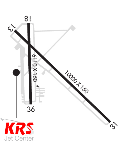
| Lat: N 3223.0 Long: W 09442.7 Elev: 366 Var: -03 Longest Runway: 10000 | ||
| Dept. ATIS: 119.65 Arr. ATIS: 119.65 AWOS: 119.65 Ground: 121.6 Tower: 119.2 | ||
| |||||||||||||||||||||||||||||||||||||||||||||||||||||||||||||||||||||
| |||||||||||||||||||||||||||||||||||||||||||||||||||||||||||||||||||||
| |||||||||||||||||||||||||||||||||||||||||||||||||||||||||||||||||||||
| |||||||||||||||||||||||||||||||||||||||||||||||||||||||||||||||||||||
| Rwy | Rwy | |||||||
| 10000x150 | 9200' | 109.50 - 130° | 10000x150 | 10000' | ||||
| 6110x150 | 6110' | 6110x150 | 6110' | |||||
| Runway ID | Single Wheel | Double Wheel | Double Tandem Wheel | Dual Double Wheel |
| 13/31 | 95,000 | 155,000 | 288,000 | N/A |
| 18/36 | 95,000 | 155,000 | 280,000 | N/A |
| These numbers are Advisory and are not limits. The Airport Manager should have more accurate Weight Limits | ||||
 Airport Diagram might not be current. | |
| Facility Name: | EAST TEXAS RGNL |
| City Name: | LONGVIEW |
| County: | GREGG |
| State abbrev: | TX |
| State Name: | TEXAS |
| Ownership: | PUBLICLY OWNED |
| Use: | OPEN TO THE PUBLIC |
| Owner's Name: | GREGG COUNTY |
| Address: | GREGG COUNTY COURTHOUSE |
| LONGVIEW, TX 75601 | |
| Owner's Phone: | 903-738-7606 |
| Manager's Name: | ROY H. MILLER AAE |
| Address: | 269 TERMINAL CIRCLE |
| LONGVIEW, TX 75603 | |
| Phone: | 903-643-3031 |
| FAA Region: | SOUTHWEST |
| FAA Field Office: | TEX |

| Date | Sunrise | Sunset |
|---|---|---|
| 09/24/21 Friday | 7:08 | 19:13 |
| 09/25/21 Saturday | 7:09 | 19:12 |
| 09/26/21 Sunday | 7:09 | 19:10 |
| 09/27/21 Monday | 7:10 | 19:09 |
| 09/28/21 Tuesday | 7:11 | 19:08 |
| 09/29/21 Wednesday | 7:11 | 19:06 |
| 09/30/21 Thursday | 7:12 | 19:05 |
| 10/01/21 Friday | 7:13 | 19:04 |
| 10/02/21 Saturday | 7:13 | 19:03 |
| 10/03/21 Sunday | 7:14 | 19:01 |
| 10/04/21 Monday | 7:15 | 19:00 |
| 10/05/21 Tuesday | 7:15 | 18:59 |
| 10/06/21 Wednesday | 7:16 | 18:57 |
| 10/07/21 Thursday | 7:17 | 18:56 |
| Airport Attendance Schedule | 7 Days A Week 0600-2100 |
| Airport Status | OPERATIONAL (This Status can change at any time - please check NOTAMS) |
| Airport Lighting Schedule | HIRL RWY 13/31 PRESET MED INTST; TO INCR INTST ACTVT - CTAF. WHEN ATCT CLSD ACTVT MALSR RWY 13 - CTAF. MIRL RWY 18/36 NOT AVBL WHEN ATCT CLSD. |
| Airport Storage Available | Tie Downs, Hanger |
| Extra Services Available | Air Freight, Charter, Flight Instruction, Aircraft Rental, Aircraft Sales |
| Wind Indicator | YES - (lighted) |
| Control Tower | YES |
| CTAF Frequency | 119.200 |
| Unicom Frequency | 122.950 |
| Rotating Beacon Color | CLEAR-GREEN (Light Land Airport) |
| Segmented Circle | YES |
| Landing Fee | NO |
| Airport Inspected | FEDERAL - performed by FAA AIRPORTS FIELD PERSONNEL |
| Inspection Date | 05/19/2021 |
| Type of Fuel Available | Grade 100LL, JET A (freeze point -40C); -10FOR FUEL AFT HRS CALL 903-643-8748. |
| Airframe Repair Service | MAJOR |
| Power Plant Repair Service | MAJOR |
| Latitude | N3223.0 |
| Longitude | W09442.7 (ESTIMATED) |
| Arpt Elevation | 365ft (SURVEYED) |
| Magnetic Variation | 03E |
| 8 miles S | of LONGVIEW |
| Traffic Pattern Altitude | |
| Sectional Chart | MEMPHIS |
| Operations (Reported) | Yearly | Avg. Daily |
|---|---|---|
| General Aviation Transient | 13795 | 38 |
| General Aviation Local | 27571 | 76 |
| Air Taxi | 10181 | 28 |
| Commerical | 31 | 0 |
| Commuter | 0 | 0 |
| Military | 4191 | 11 |
| Aircraft based on Field | |
|---|---|
| General Aviation Singles | 46 |
| General Aviation Multi | 21 |
| Jet Aircraft | 22 |
| General Aviation Helicopters | 1 |
| Military Aircraft | 0 |
| Gliders | 0 |
| Ultralights | 0 |
| FSS on field | NO |
| FSS tie-in | FORT WORTH |
| FSS Phone | 1-800-WX-BRIEF |
| Who issues Notams | GGG |
| Notam D service at airport | YES |
| ARTCC Name | FORT WORTH |
| Airport Certification | AIRPORT RECEIVING SCHEDULED AIR CARRIER SERVICE FROM CARRIERS CERTIFICATED BY THE CIVIL AERONAUTICS BOARD; PPR FOR UNSCHEDULED ACR OPNS WITH OVER 30 PSGR SEATS. INDEX B AVBL ON REQUEST. |
| Aircraft Rescue & Firefighting Index | AIRPORT HAS A CERTIFICATE UNDER CFR PART 139 |
| Airport of Entry | No |
| Custom Landing Rights | No |
| Joint Civil/Military | No |
| Military Landing rights | YES |
| NATIONAL PLAN OF INTEGRATED AIRPORT SYSTEMS (NPIAS) |
| GRANT AGREEMENTS UNDER FAAP/ADAP/AIP |
| ASSURANCES PURSUANT TO TITLE VI, CIVIL RIGHTS ACT OF 1964 |
| AGREEMENT UNDER DLAND OR DCLA HAS EXPIRED. |
| BIRDS ON & INVOF ARPT (SEASONAL). |
Airport Communications & Frequencies:
| |||||||||||||||||||||||||||||||||||||||||||||||||||||
| Runway: 13 | Runway: 31 | ||
| Mag heading: | 131° | Mag heading: | 311° |
| Rwy Slope: | -.04% Down | Rwy Slope: | .04% Up |
| Approach: | ILS | Approach: | |
| Pattern: | Left Traffic | Pattern: | Left Traffic |
| Markings: | PRECISION INSTRUMENT | Markings: | PRECISION INSTRUMENT |
| Marking Condition: | GOOD | Marking Condition: | GOOD |
| Arresting Dev: | Arresting Dev: | ||
| Lat & Long: | N3223.6 W09443.2 | Lat. & Long.: | N3222.4 W09441.8 |
| Elev: | 357.7 ft. MSL | Elev: | 353.9 ft. MSL |
| TCH: | TCH: | 50 ft. AGL | |
| Visual Glide Path: | Visual Glide Path: | 3.00 degrees | |
| Displaced Threshold: | 800 feet | Displaced Threshold: | No |
| Touchdown Zone: | YES | Touchdown Zone: | YES |
| Touchdown Elev.: | 357.7 feet | Touchdown Elev.: | 354.1 feet |
| Visual Glide Slope: | Visual Glide Slope: | 4-Light PAPI on LEFT side of Runway | |
| RVR Equipment: | TOUCHDOWN | RVR Equipment: | ROLLOUT |
| RVV Equipment: | NO | RVV Equipment: | NO |
| Approach Lights: | MALSR - 1,400 foot medium intensity approach lighting system with runway alignment indicator lights | Approach Lights: | |
| REIL: | NO | REIL: | NO |
| Centerline Lights: | NO | Centerline Lights: | NO |
| Touchdown lights: | NO | Touchdown lights: | NO |
| Runway Category: | Precision Instrument Runway | Runway Category: | Runway with a Non-precision Approach having visibility minimums greater than 3/4 mile |
| Declared Distances: | TORA:10000' TODA:10000' ASDA:10000' LDA:9200' | Declared Distances: | TORA:10000' TODA:10000' ASDA:9200' LDA:9200' |
| Comments: | +7 FT ROAD 194 FT FM THR 474 FT R. | Comments: |
| Runway: 18 | Runway: 36 | ||
| Mag heading: | 176° | Mag heading: | 356° |
| Rwy Slope: | .18% Up | Rwy Slope: | -.18% Down |
| Approach: | Approach: | ||
| Pattern: | Left Traffic | Pattern: | Left Traffic |
| Markings: | NONPRECISION INSTRUMENT | Markings: | NONPRECISION INSTRUMENT |
| Marking Condition: | GOOD | Marking Condition: | GOOD |
| Arresting Dev: | Arresting Dev: | ||
| Lat & Long: | N3223.6 W09443.0 | Lat. & Long.: | N3222.6 W09443.0 |
| Elev: | 354.3 ft. MSL | Elev: | 365.5 ft. MSL |
| TCH: | 59 ft. AGL | TCH: | 50 ft. AGL |
| Visual Glide Path: | 3.00 degrees | Visual Glide Path: | 3.00 degrees |
| Displaced Threshold: | No | Displaced Threshold: | No |
| Touchdown Zone: | YES | Touchdown Zone: | YES |
| Touchdown Elev.: | 356.0 feet | Touchdown Elev.: | 365.5 feet |
| Visual Glide Slope: | 4-Light PAPI on LEFT side of Runway | Visual Glide Slope: | 4-Light PAPI on RIGHT side of Runway; PAPI UNSBL BYD 8 DEG RIGHT OF RCL. |
| RVR Equipment: | RVR Equipment: | ||
| RVV Equipment: | NO | RVV Equipment: | NO |
| Approach Lights: | Approach Lights: | ||
| REIL: | NO | REIL: | NO |
| Centerline Lights: | NO | Centerline Lights: | NO |
| Touchdown lights: | NO | Touchdown lights: | NO |
| Runway Category: | Runway with a Visual Approach | Runway Category: | Runway with a Visual Approach |
| Declared Distances: | TORA:6109' TODA:6109' ASDA:6109' LDA:6109' | Declared Distances: | TORA:6109' TODA:6109' ASDA:6109' LDA:6109' |
| Obstructions: | TREE | Obstructions: | TREE |
| Marked: | NOT Marked/Lighted | Marked: | NOT Marked/Lighted |
| Clearance slope: | 30:1 | Clearance slope: | 31:1 |
| Obstruction height: | 46 feet AGL | Obstruction height: | 52 feet AGL |
| Dist. from runway: | 1584 feet | Dist. from runway: | 1813 feet |
| Centerline offset: | 465 right of centerline | Centerline offset: | 446 feet right of centerline |
| Comments: | Comments: |
Thanks for using FltPlan.com
all rights reserved © 1999-2021 by Flight Plan LLC