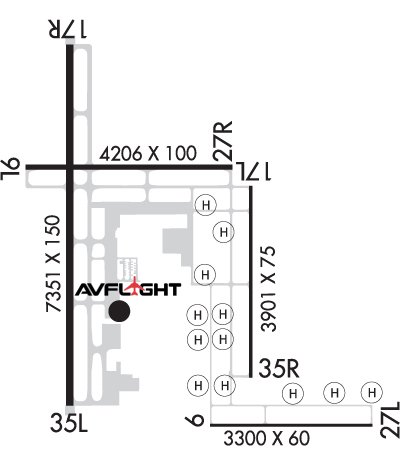
Airport & FBO Info for KGFK/GFK GRAND FORKS INTL GRAND FORKS ND
Click for contest details.

KGFK

GRAND FORKS INTL       GRAND FORKS       ND
  Time Zone: Central 
Lat: N 4756.9     Long: W 09710.5    Elev: 845     Var: -06  Longest Runway: 7351
Clr Del: 135.72       Dept. ATIS: 119.4     Arr. ATIS: 119.4     AWOS: 119.4   Ground: 124.57     Tower: 118.4/120.55

FBO & Flight Services info for KGFK

FBOs: Update your Fuel Prices

AVFLIGHTPh: 701-772-5504 Fax: 701-772-8917 Freq: 129.95
Service
Jet
100LL
80/87
MoGas
Fuel Avail: JET A w/PRIST $7.09/gal. 0500-2200 - On Call 24/7
Full8.717.25    Last Update: 06/02/2026 11:41

prist $0.10 per gallon
Self  6.75    
 Address: 2403 AIR CARGO DR GRAND FORKS,   ND 58203
ASOSPh: 701-772-3486
-
Freq: 119.4  
If you are an FBO, call 1-203-262-8900 to update your info or email: Support@FltPlan.com
Advertise your FBO on FltPlan.com
FBOs at nearby airports who want your business:
KFAR


  click here  
Open 24/7 with US Customs on-site, experience unmatched convenience, quick turns, and premium service. Fuel up with Jet A and 100LL at competitive prices, and discover why we are a top-rated FBO, recognized for uncompromising standards of quality and excellence. Our large hangars accommodate up to Global/G650 aircraft. Earn Avtrip Points on every gallon of fuel. Explore more at www.fargojet.com.
Ph: 1-800-770-0538WebsiteE-Mail Fax: 1-701-237-6887 Freq: 130.52

Runway & Approach Info for KGFK
Rwy
Length
Land Dist**
Approach*
  Rwy
Length
Land Dist**
Approach*
09L
6701x100  6701'          
 
  
27R
  6701x100  6701'          
 
09R
3300x60  3300'          
 
  
27L
  3300x60  3300'          
 
17L
3901x75  3901'          
 
  
35R
  3901x75  3901'          
 
17R
7351x150  7351'          
 
  
35L
  7351x150  7351'          
ILS/DME
 109.10 - 354°  
 * only ILS, LOC, LDA, and SDF approaches to a specific runway are shown
** For any Declared Landing Distance Available, please see A/FD or Approach plates
Runway Weight Capability (lbs.) Help
Runway IDSingle WheelDouble WheelDouble Tandem WheelDual Double Wheel
09L/27R120,000198,000321,000760,000
09R/27L12,500N/AN/AN/A
17L/35R12,500N/AN/AN/A
17R/35L120,000250,000550,000N/A
H1N/AN/AN/AN/A
H10N/AN/AN/AN/A
H11N/AN/AN/AN/A
H12N/AN/AN/AN/A
H2N/AN/AN/AN/A
H3N/AN/AN/AN/A
H4N/AN/AN/AN/A
H5N/AN/AN/AN/A
H6N/AN/AN/AN/A
H7N/AN/AN/AN/A
H8N/AN/AN/AN/A
H9N/AN/AN/AN/A
These numbers are Advisory and are not limits.   The Airport Manager should have more accurate Weight Limits
Please email Support@FltPlan.com for further information.
Approach Charts
Approaches    
Current Weather/Notams
Customs Information Send updates to Support@FltPlan.com
Phone 701-772-3301
Fax 701-772-0052

Comments Available 24/7/365 to clear int'l arrivals. Two hours advanced notice required prior to arrival. Phone call required; you must speak with an officer (use phone options). Maximum passengers per flight: 10 plus crew. EMAIL: EASTNDAIRPORTS@CBP.DHS.GOV
Database effective 07/09/2026
Airport Diagram of KGFK
Airport Diagram might not be current.

Facility Name: GRAND FORKS INTL
City Name: GRAND FORKS
County: GRAND FORKS
State abbrev: ND
State Name: NORTH DAKOTA
   
Ownership: PUBLICLY OWNED
Use: OPEN TO THE PUBLIC
Owner's Name: GRAND FORKS REG ARPT AUTH
Address: 2301 AIRPORT DRIVE
 GRAND FORKS, ND 58203
Owner's Phone: 701-795-6981
  
Manager's Name: RYAN RIESINGER
Address: 2301 AIRPORT DR
 GRAND FORKS, ND 58203
Phone: 701-795-6981
   
FAA Region: GREAT LAKES
FAA Field Office: DMA


Sunrise / Sunset times for GRAND FORKS INTL

DateSunriseSunset
06/12/26 Friday5:2921:28
06/13/26 Saturday5:2921:29
06/14/26 Sunday5:2921:29
06/15/26 Monday5:2921:30
06/16/26 Tuesday5:2921:30
06/17/26 Wednesday5:2921:30
06/18/26 Thursday5:2921:31
06/19/26 Friday5:2921:31
06/20/26 Saturday5:2921:31
06/21/26 Sunday5:2921:32
06/22/26 Monday5:2921:32
06/23/26 Tuesday5:3021:32
06/24/26 Wednesday5:3021:32
06/25/26 Thursday5:3021:32

Airport Facilities

Airport Attendance ScheduleCONTINUOUS
Airport Status OPERATIONAL (This Status can change at any time - please check NOTAMS)
Airport Lighting ScheduleWHEN TWR CLSD ACTVT MALSR RWY 35L; REIL RWY 09L, 17R, & 27R; MIRL RWY 09L/27R; MIRL 9R/27L; MIRL RWY 17L/35R; HIRL RWY 17R/35L - CTAF. PAPI RWY 09L, 09R, 17L, 17R, 27L, 27R, 35L, 35R OPR CONSLY.
Airport Storage AvailableTie Downs
Extra Services AvailableCargo Handling, Charter, Flight Instruction, Aircraft Rental, Aircraft Sales, Annual Surveying
Wind IndicatorYES - (lighted)
Control TowerYES
CTAF Frequency118.400
Unicom Frequency122.950
Rotating Beacon ColorWG
Segmented CircleNO
Landing FeeNO

Airport Inspection Data

Airport InspectedFEDERAL - performed by FAA AIRPORTS FIELD PERSONNEL
Inspection Date06/25/2025

Airport Services

Type of Fuel AvailableGrade 100LL, JET A (freeze point -40C)
Airframe Repair ServiceMAJOR
Power Plant Repair ServiceMAJOR

Geographic Data

LatitudeN4756.9
LongitudeW09710.5 (ESTIMATED)
Arpt Elevation845ft (SURVEYED)
Magnetic Variation06E
5 miles NWof GRAND FORKS
Traffic Pattern Altitude800
Sectional ChartTWIN CITIES

Aircraft Data

Operations (Reported)YearlyAvg. Daily
General Aviation Transient 00
General Aviation Local 00
Air Taxi 00
Commerical 00
Commuter 00
Military 00
Aircraft based on Field
General Aviation Singles 0
General Aviation Multi 0
Jet Aircraft 0
General Aviation Helicopters 0
Military Aircraft 0
Gliders 0
Ultralights 0

FAA Services

FSS on field NO
FSS tie-in GRAND FORKS
FSS Phone 1-800-WX-BRIEF
Who issues Notams GFK
Notam D service at airport YES
ARTCC Name MINNEAPOLIS

Federal Status

Airport CertificationAIRPORT RECEIVING SCHEDULED AIR CARRIER SERVICE FROM CARRIERS CERTIFICATED BY THE CIVIL AERONAUTICS BOARD; ARFF INDEX C SVCS AVBL WITH 24 HR PPR. CALL AMGR AT 701-795-6984.
Aircraft Rescue & Firefighting IndexAIRPORT HAS A CERTIFICATE UNDER CFR PART 139
Airport of EntryYES
Custom Landing RightsNo
Joint Civil/MilitaryNo
Military Landing rightsYES

Federal Agreements

NATIONAL PLAN OF INTEGRATED AIRPORT SYSTEMS (NPIAS)
GRANT AGREEMENTS UNDER FAAP/ADAP/AIP
ASSURANCES PURSUANT TO TITLE VI, CIVIL RIGHTS ACT OF 1964

Remarks

HVY STUDENT TRNG ACTVTY WI 15 MI OF ARPT.
TWY G, TWY N, & TWY U CLSD TO FIXED WING ACFT 12,500 LBS & OVER.
WESTERN MOST 100 FT OF TWY C1 IS AN EXTENSION OF THE BRAVO APRON & NOT VSBL FR THE TWR.
TWY C SOUTH OF TWY B, TWY E, TWY S NOT AVBL FOR SKED ACR OPNS WITH MORE THAN 9 PSGR SEATS OR UNSKED ACR OPNS WITH AT LEAST 31 PSGR SEATS.
FOR CD IF UNA TO CTC ON FSS FREQ, CTC MINNEAPOLIS ARTCC AT 651-463-5588.
BIRDS ON & INVOF ARPT.
RWY 17R SEGMENTED CIRCLE U/S.
LGTD ENTRANCE RD 1600' EAST OF RY 17R/35L.
CUSTOMS AVBL 24/7/365. YOU MUST SPEAK WITH AN OFFICER BEFORE ARRIVAL (USE PHONE OPTIONS) 701-772-3301 OR 701-772-6433.
PAEW 2330-0600 LOCAL
HVY STUDENT HELICOPTER TRAINING AT ARPT BTN PARALLEL TWYS.-
(CONTACT NAME) ARPT OPS & FAC MGR.
RWY 09R/ 27LRWY 09R/27L NOT AVBL FOR PART 121/PART 380 OPS WITH SKED PAX CARRYING OPS MORE THAN 9 PAX SEATS AND NON-SKED PAX CARRYING OPS MORE THAN 30 PAX SEATS.
RWY 17L/ 35RRWY 17L/35R NOT AVBL FOR PART 121/PART 380 OPS WITH SKED PAX CARRYING OPS MORE THAN 9 PAX SEATS AND NON-SKED PAX CARRYING OPS MORE THAN 30 PAX SEATS.
RWY 09L/ 27RPCR VALUE: 630/R/C/W/T
RWY 09R/ 27LPCR VALUE: 150/R/C/W/T
RWY 17L/ 35RPCR VALUE: 150/R/C/W/T
RWY 17R/ 35LPCR VALUE: 1000/R/C/W/T
Airport Communications & Frequencies:
ATIS Frequencies:   Hours(local) of Operation: CONTINUOUS
119.4
GRAND FORKS Tower Frequencies:   Hours(local) of operation: 0600-2330   
118.4 ;HELICOPTERS
118.4 ;RWY 17R/35L, ;09L/27R
120.55 ;RWY 17L/35R, ;09R/27L
350.35
GRAND FORKS Ground Frequencies:
124.575
Clearance Delivery Frequencies:
135.725
CTAF Frequency:
118.400
Unicom Frequency:
122.950
Remarks
  • APCH/DEP SVC PRVDD BY MINNEAPOLIS ARTCC (ZMP) ON FREQ 132.15/269.6 (GRAND FORKS RCAG) WHEN GRAND FORKS (RDR) APCH CTL CLSD.
  • SAID IN USE. OPERATE TRANSPONDERS WITH ALTITUDE REPORTING MODE AND ADS-B (IF EQUIPPED) ENABLED ON ALL AIRPORT SURFACES.
  • WHEN ATCT IS CLSD SNOW REMOVAL EQUIPMENT OPERATORS MONITOR CTAF.
  • GRAND FORKS Primary Approach Frequencies:  
    118.1
    318.1
    GRAND FORKS Primary Departure Frequencies:  
    118.1
    318.1
    Runway Identifications
    Runway Identification: 09L/27R
    Length: 6701 ft
    Width: 100 ft
    Surface: CONCRETE-GOOD CONDITION
    Edge lights: Medium Intensity

    Treatment: GROOVED

     Runway: 09L   Runway: 27R
    Mag heading: 84°Mag heading: 264°
    Rwy Slope: -.04% DownRwy Slope: .04% Up
    Approach: Approach:
    Pattern: Left TrafficPattern: Right Traffic
    Markings: NONPRECISION INSTRUMENTMarkings: NONPRECISION INSTRUMENT
    Marking Condition: GOODMarking Condition: GOOD
    Arresting Dev: Arresting Dev:
    Lat & Long: N4757.1  W09711.7Lat. & Long.: N4757.1  W09710.1
    Elev: 845.1 ft. MSLElev: 842.6 ft. MSL
    TCH: 45 ft. AGLTCH: 44 ft. AGL
    Visual Glide Path: 3.00 degreesVisual Glide Path: 3.00 degrees
    Displaced Threshold: NoDisplaced Threshold: No
    Touchdown Zone: YESTouchdown Zone: YES
    Touchdown Elev.: 845.2 feetTouchdown Elev.: 842.9 feet
    Visual Glide Slope: 4-Light PAPI on LEFT side of RunwayVisual Glide Slope: 4-Light PAPI on LEFT side of Runway
    RVR Equipment: RVR Equipment:
    RVV Equipment: NORVV Equipment: NO
    Approach Lights: Approach Lights:
    REIL: YESREIL: YES
    Centerline Lights: NOCenterline Lights: NO
    Touchdown lights: NOTouchdown lights: NO
    Runway Category: DRunway Category: D
    Declared Distances: TORA:6701' TODA:6701' ASDA:6701' LDA:6701'Declared Distances: TORA:6701' TODA:6701' ASDA:6701' LDA:6701'
    Runway Identification: 09R/27L
    Length: 3300 ft
    Width: 60 ft
    Surface: CONCRETE-GOOD CONDITION
    Edge lights: Medium Intensity

    Treatment: NONE
    Weight: PCN 10 /R/C/W/T

     Runway: 09R   Runway: 27L
    Mag heading: 84°Mag heading: 264°
    Rwy Slope: .00% DownRwy Slope: .00% Up
    Approach: Approach:
    Pattern: Right TrafficPattern: Left Traffic
    Markings: BASICMarkings: BASIC
    Marking Condition: GOODMarking Condition: GOOD
    Arresting Dev: Arresting Dev:
    Lat & Long: N4756.3  W09710.2Lat. & Long.: N4756.3  W09709.4
    Elev: 843.7 ft. MSLElev: 843.6 ft. MSL
    TCH: 21 ft. AGLTCH: 21 ft. AGL
    Visual Glide Path: 3.00 degreesVisual Glide Path: 3.00 degrees
    Displaced Threshold: NoDisplaced Threshold: No
    Touchdown Zone: YESTouchdown Zone: YES
    Touchdown Elev.: 843.8 feetTouchdown Elev.: 843.7 feet
    Visual Glide Slope: 2-Light PAPI on LEFT side of RunwayVisual Glide Slope: 2-Light PAPI on LEFT side of Runway
    RVR Equipment: RVR Equipment:
    RVV Equipment: NORVV Equipment: NO
    Approach Lights: Approach Lights:
    REIL: NOREIL: NO
    Centerline Lights: NOCenterline Lights: NO
    Touchdown lights: NOTouchdown lights: NO
    Runway Category: Runway with a Visual ApproachRunway Category: Runway with a Visual Approach
    Declared Distances: TORA:3300' TODA:3300' ASDA:3300' LDA:3300'Declared Distances: TORA:3300' TODA:3300' ASDA:3300' LDA:3300'
    Runway Identification: 17L/35R
    Length: 3901 ft
    Width: 75 ft
    Surface: CONCRETE-FAIR CONDITION
    Edge lights: Medium Intensity

    Treatment: NONE

     Runway: 17L   Runway: 35R
    Mag heading: 174°Mag heading: 354°
    Rwy Slope: .04% UpRwy Slope: -.04% Down
    Approach: Approach:
    Pattern: Left TrafficPattern: Right Traffic
    Markings: NONPRECISION INSTRUMENTMarkings: NONPRECISION INSTRUMENT
    Marking Condition: GOODMarking Condition: GOOD
    Arresting Dev: Arresting Dev:
    Lat & Long: N4757.1  W09710.0Lat. & Long.: N4756.4  W09710.0
    Elev: 841.8 ft. MSLElev: 843.3 ft. MSL
    TCH: 21 ft. AGLTCH: 21 ft. AGL
    Visual Glide Path: 3.00 degreesVisual Glide Path: 3.00 degrees
    Displaced Threshold: NoDisplaced Threshold: No
    Touchdown Zone: YESTouchdown Zone: YES
    Touchdown Elev.: 843.3 feetTouchdown Elev.: 843.7 feet
    Visual Glide Slope: 4-Light PAPI on LEFT side of RunwayVisual Glide Slope: 4-Light PAPI on LEFT side of Runway
    RVR Equipment: RVR Equipment:
    RVV Equipment: NORVV Equipment: NO
    Approach Lights: Approach Lights:
    REIL: NOREIL: NO
    Centerline Lights: NOCenterline Lights: NO
    Touchdown lights: NOTouchdown lights: NO
    Runway Category: Runway with a Non-precision ApproachRunway Category: Runway with a Non-precision Approach
    Declared Distances: TORA:3901' TODA:3901' ASDA:3901' LDA:3901'Declared Distances: TORA:3901' TODA:3901' ASDA:3901' LDA:3901'
    Runway Identification: 17R/35L
    Length: 7351 ft
    Width: 150 ft
    Surface: ASPHALT-FAIR CONDITION
    Edge lights: High Intensity

    Treatment: GROOVED

     Runway: 17R   Runway: 35L
    Mag heading: 174°Mag heading: 354°
    Rwy Slope: .02% UpRwy Slope: -.02% Down
    Approach: Approach: ILS/DME
    Pattern: Right TrafficPattern: Left Traffic
    Markings: PRECISION INSTRUMENTMarkings: PRECISION INSTRUMENT
    Marking Condition: GOODMarking Condition: GOOD
    Arresting Dev: Arresting Dev:
    Lat & Long: N4757.6  W09710.9Lat. & Long.: N4756.3  W09710.9
    Elev: 843.0 ft. MSLElev: 844.6 ft. MSL
    TCH: 53 ft. AGLTCH: 61 ft. AGL
    Visual Glide Path: 3.00 degreesVisual Glide Path: 2.76 degrees
    Displaced Threshold: NoDisplaced Threshold: No
    Touchdown Zone: YESTouchdown Zone: YES
    Touchdown Elev.: 843.0 feetTouchdown Elev.: 844.6 feet
    Visual Glide Slope: 4-Light PAPI on LEFT side of RunwayVisual Glide Slope: 4-Light PAPI on LEFT side of Runway
    RVR Equipment: ROLLOUTRVR Equipment: TOUCHDOWN
    RVV Equipment: NORVV Equipment: NO
    Approach Lights: Approach Lights: MALSR - 1,400 foot medium intensity approach lighting system with runway alignment indicator lights
    REIL: YESREIL: NO
    Centerline Lights: NOCenterline Lights: NO
    Touchdown lights: NOTouchdown lights: NO
    Runway Category: DRunway Category: Precision Instrument Runway
    Declared Distances: TORA:7351' TODA:7351' ASDA:7351' LDA:7351'Declared Distances: TORA:7351' TODA:7351' ASDA:7351' LDA:7351'
    Runway Identification: H1 HELIPAD
    Length: 60 ft
    Width: 60 ft
    Surface: GRASS
    Edge lights:

    Treatment: NONE

    Runway Identification: H10 HELIPAD
    Length: 60 ft
    Width: 60 ft
    Surface: GRASS
    Edge lights:

    Treatment: NONE

    Runway Identification: H11 HELIPAD
    Length: 60 ft
    Width: 60 ft
    Surface: GRASS
    Edge lights:

    Treatment: NONE

    Runway Identification: H12 HELIPAD
    Length: 60 ft
    Width: 60 ft
    Surface: GRASS
    Edge lights:

    Treatment: NONE

    Runway Identification: H2 HELIPAD
    Length: 60 ft
    Width: 60 ft
    Surface: GRASS
    Edge lights:

    Treatment: NONE

    Runway Identification: H3 HELIPAD
    Length: 60 ft
    Width: 60 ft
    Surface: GRASS
    Edge lights:

    Treatment: NONE

    Runway Identification: H4 HELIPAD
    Length: 60 ft
    Width: 60 ft
    Surface: GRASS
    Edge lights:

    Treatment: NONE

    Runway Identification: H5 HELIPAD
    Length: 60 ft
    Width: 60 ft
    Surface: GRASS
    Edge lights:

    Treatment: NONE

    Runway Identification: H6 HELIPAD
    Length: 60 ft
    Width: 60 ft
    Surface: GRASS
    Edge lights:

    Treatment: NONE

    Runway Identification: H7 HELIPAD
    Length: 60 ft
    Width: 60 ft
    Surface: GRASS
    Edge lights:

    Treatment: NONE

    Runway Identification: H8 HELIPAD
    Length: 60 ft
    Width: 60 ft
    Surface: GRASS
    Edge lights:

    Treatment: NONE

    C:30/P: