
| SHELBYVILLE MUNI SHELBYVILLE IN |
| |
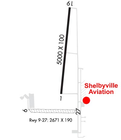
| Lat: N 3935.0 Long: W 08548.3 Elev: 803 Var: +04 Longest Runway: 5000 | ||
| AWOS: 121.55 CTAF: 122.8 | ||
| ||||||||||||||||||||||||||||||||||||||||||||
| ||||||||||||||||||||||||||||||||||||||||||||
| ||||||||||||||||||||||||||||||||||||||||||||
| Rwy | Rwy | |||||||
| 5000x100 | 5000' | 5000x100 | 5000' | |||||
| 2671x190 | 2225' | 2671x190 | 2382' | |||||
| Runway ID | Single Wheel | Double Wheel | Double Tandem Wheel | Dual Double Wheel |
| 01/19 | 30,000 | 40,000 | N/A | N/A |
| 09/27 | N/A | N/A | N/A | N/A |
| These numbers are Advisory and are not limits. The Airport Manager should have more accurate Weight Limits | ||||
 Airport Diagram might not be current. | |
| Facility Name: | SHELBYVILLE MUNI |
| City Name: | SHELBYVILLE |
| County: | SHELBY |
| State abbrev: | IN |
| State Name: | INDIANA |
| Ownership: | PUBLICLY OWNED |
| Use: | OPEN TO THE PUBLIC |
| Owner's Name: | SHELBYVILLE BOAC |
| Address: | 44 W WASHINGTON ST |
| SHELBYVILLE, IN 46176 | |
| Owner's Phone: | 317-398-6624 |
| Manager's Name: | MARANDA SMITH |
| Address: | 3529 N 100 WEST |
| SHELBYVILLE, IN 46176 | |
| Phone: | 317-392-1284 |
| FAA Region: | GREAT LAKES |
| FAA Field Office: | CHI |
| Date | Sunrise | Sunset |
|---|---|---|
| 06/08/26 Monday | 6:16 | 21:09 |
| 06/09/26 Tuesday | 6:15 | 21:10 |
| 06/10/26 Wednesday | 6:15 | 21:10 |
| 06/11/26 Thursday | 6:15 | 21:11 |
| 06/12/26 Friday | 6:15 | 21:11 |
| 06/13/26 Saturday | 6:15 | 21:12 |
| 06/14/26 Sunday | 6:15 | 21:12 |
| 06/15/26 Monday | 6:15 | 21:12 |
| 06/16/26 Tuesday | 6:15 | 21:13 |
| 06/17/26 Wednesday | 6:15 | 21:13 |
| 06/18/26 Thursday | 6:15 | 21:13 |
| 06/19/26 Friday | 6:15 | 21:14 |
| 06/20/26 Saturday | 6:16 | 21:14 |
| 06/21/26 Sunday | 6:16 | 21:14 |
| Airport Attendance Schedule | 7 Days A Week 0800-1800; ATNDD IREG ON HOLS |
| Airport Status | OPERATIONAL (This Status can change at any time - please check NOTAMS) |
| Airport Lighting Schedule | ACTVT REIL RWY 01 & 19; PAPI RWY 01; VASI RWY 19; MIRL RWY 01/19 - CTAF. |
| Airport Storage Available | Tie Downs, Hanger |
| Extra Services Available | Flight Instruction, Aircraft Rental |
| Wind Indicator | YES - (lighted) |
| Control Tower | NO |
| CTAF Frequency | 122.800 |
| Unicom Frequency | 122.800 |
| Rotating Beacon Color | WG |
| Segmented Circle | NO |
| Landing Fee | NO |
| Airport Inspected | STATE - performed by STATE AERONAUTICAL PERSONNEL |
| Inspection Date | 12/09/2025 |
| Type of Fuel Available | Grade 100LL, JET A (freeze point -40C), JET A; -10100LL SELF SERVE AVBL |
| Airframe Repair Service | MAJOR |
| Power Plant Repair Service | MAJOR |
| Latitude | N3935.0 |
| Longitude | W08548.3 (ESTIMATED) |
| Arpt Elevation | 802ft (SURVEYED) |
| Magnetic Variation | 04W |
| 4 miles NW | of SHELBYVILLE |
| Traffic Pattern Altitude | 800 |
| Sectional Chart | ST LOUIS |
| Operations (Reported) | Yearly | Avg. Daily |
|---|---|---|
| General Aviation Transient | 0 | 0 |
| General Aviation Local | 0 | 0 |
| Air Taxi | 0 | 0 |
| Commerical | 0 | 0 |
| Commuter | 0 | 0 |
| Military | 0 | 0 |
| Aircraft based on Field | |
|---|---|
| General Aviation Singles | 0 |
| General Aviation Multi | 0 |
| Jet Aircraft | 0 |
| General Aviation Helicopters | 0 |
| Military Aircraft | 0 |
| Gliders | 0 |
| Ultralights | 0 |
| FSS on field | NO |
| FSS tie-in | TERRE HAUTE |
| FSS Phone | 1-800-WX-BRIEF |
| Who issues Notams | GEZ |
| Notam D service at airport | YES |
| ARTCC Name | INDIANAPOLIS |
| Airport Certification | |
| Aircraft Rescue & Firefighting Index | None |
| Airport of Entry | No |
| Custom Landing Rights | No |
| Joint Civil/Military | No |
| Military Landing rights | YES |
| NATIONAL PLAN OF INTEGRATED AIRPORT SYSTEMS (NPIAS) |
| GRANT AGREEMENTS UNDER FAAP/ADAP/AIP |
| ASSURANCES PURSUANT TO TITLE VI, CIVIL RIGHTS ACT OF 1964 |
| THIS AIRPORT HAS BEEN SURVEYED BY THE NATIONAL GEODETIC SURVEY. |
| HELICOPTER TFC ALL HRS. ANG HELI LCTD W OF ARPT. |
| CTC ANG OPS 41.5/143.6/347.55. |
| AP HEL LESS THAN 5000 LB VFR TFC PAT ALT 500 FT AGL. |
Airport Communications & Frequencies:
| ||||||||||||||
| Runway: 01 | Runway: 19 | ||
| Mag heading: | 9° | Mag heading: | 189° |
| Rwy Slope: | .02% Up | Rwy Slope: | -.02% Down |
| Approach: | Approach: | ||
| Pattern: | Left Traffic | Pattern: | Left Traffic |
| Markings: | NONPRECISION INSTRUMENT | Markings: | NONPRECISION INSTRUMENT |
| Marking Condition: | GOOD | Marking Condition: | GOOD |
| Arresting Dev: | Arresting Dev: | ||
| Lat & Long: | N3934.8 W08548.3 | Lat. & Long.: | N3935.6 W08548.2 |
| Elev: | 801.3 ft. MSL | Elev: | 802.3 ft. MSL |
| TCH: | 25 ft. AGL | TCH: | 38 ft. AGL |
| Visual Glide Path: | 3.00 degrees | Visual Glide Path: | 3.00 degrees |
| Displaced Threshold: | No | Displaced Threshold: | No |
| Touchdown Zone: | YES | Touchdown Zone: | YES |
| Touchdown Elev.: | 801.6 feet | Touchdown Elev.: | 802.5 feet |
| Visual Glide Slope: | 2-Light PAPI on LEFT side of Runway | Visual Glide Slope: | 4-BOX VASI ON LEFT SIDE OF RUNWAY |
| RVR Equipment: | RVR Equipment: | ||
| RVV Equipment: | NO | RVV Equipment: | NO |
| Approach Lights: | Approach Lights: | ||
| REIL: | YES | REIL: | YES |
| Centerline Lights: | NO | Centerline Lights: | NO |
| Touchdown lights: | NO | Touchdown lights: | NO |
| Runway Category: | Runway with a Non-precision Approach | Runway Category: | Runway with a Non-precision Approach |
| Declared Distances: | Declared Distances: |
| Runway: 09 | Runway: 27 | ||
| Mag heading: | 96° | Mag heading: | 276° |
| Rwy Slope: | .37% Up | Rwy Slope: | -.37% Down |
| Approach: | Approach: | ||
| Pattern: | Left Traffic | Pattern: | Left Traffic |
| Markings: | NONE | Markings: | NONE |
| Marking Condition: | Marking Condition: | RWY BEGINS W SIDE OF TWY A; GRASS LINE MARKS RWY EDGES. | |
| Arresting Dev: | Arresting Dev: | ||
| Lat & Long: | N3934.6 W08548.7 | Lat. & Long.: | N3934.6 W08548.1 |
| Elev: | 790.0 ft. MSL | Elev: | 800.0 ft. MSL |
| TCH: | TCH: | ||
| Visual Glide Path: | Visual Glide Path: | ||
| Displaced Threshold: | 446 feet; RWY 09/27 DSPLCD THLDS MKD WITH YELLOW CONES. | Displaced Threshold: | 289 feet |
| Touchdown Zone: | YES | Touchdown Zone: | YES |
| Touchdown Elev.: | 793.0 feet | Touchdown Elev.: | 800.0 feet |
| Visual Glide Slope: | Visual Glide Slope: | ||
| RVR Equipment: | RVR Equipment: | ||
| RVV Equipment: | NO | RVV Equipment: | NO |
| Approach Lights: | Approach Lights: | ||
| REIL: | NO | REIL: | NO |
| Centerline Lights: | NO | Centerline Lights: | NO |
| Touchdown lights: | NO | Touchdown lights: | NO |
| Runway Category: | Runway with a Visual Approach | Runway Category: | Runway with a Visual Approach |
| Declared Distances: | Declared Distances: | ||
| Obstructions: | ROAD | Obstructions: | BLDG |
| Marked: | NOT Marked/Lighted | Marked: | LIGHTED |
| Clearance slope: | 10:1; APCH SLOPE 40:1 AT DSPLCD THR. | Clearance slope: | 14:1; APCH RATIO 27:1 TO DSPLCD THLD. |
| Obstruction height: | 150 feet AGL | Obstruction height: | 23 feet AGL |
| Dist. from runway: | 15 feet | Dist. from runway: | 325 feet |
| Centerline offset: | Centerline offset: | 120 feet right of centerline | |
| Comments: | Comments: |
Thanks for using FltPlan.com
all rights reserved © 1999-2026 by Flight Plan LLC
