
| SOUTH BIG HORN COUNTY GREYBULL WY |
| |
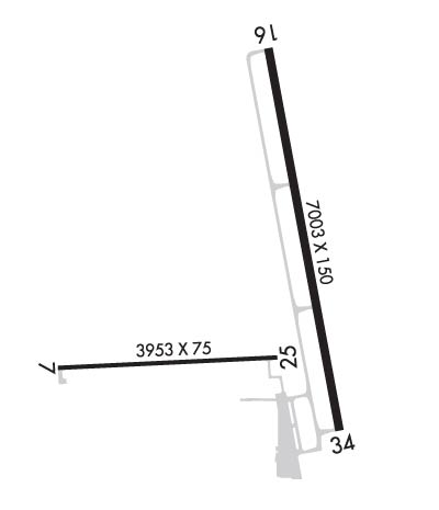
| Lat: N 4431.1 Long: W 10805.0 Elev: 3942 Var: -10 Longest Runway: 7003 | ||
| AWOS: 135.32 CTAF: 122.9 | ||
| |||||||||||||||||||||||||||||||||||||||
| |||||||||||||||||||||||||||||||||||||||
| |||||||||||||||||||||||||||||||||||||||
| |||||||||||||||||||||||||||||||||||||||
| Rwy | Rwy | |||||||
| 3953x75 | 3953' | 3953x75 | 3953' | |||||
| 7003x150 | 7003' | 7003x150 | 7003' | |||||
| Runway ID | Single Wheel | Double Wheel | Double Tandem Wheel | Dual Double Wheel |
| 08/26 | 12,500 | N/A | N/A | N/A |
| 16/34 | 85,000 | 150,000 | 290,000 | N/A |
| These numbers are Advisory and are not limits. The Airport Manager should have more accurate Weight Limits | ||||
 Airport Diagram might not be current. | |
| Facility Name: | SOUTH BIG HORN COUNTY |
| City Name: | GREYBULL |
| County: | BIG HORN |
| State abbrev: | WY |
| State Name: | WYOMING |
| Ownership: | PUBLICLY OWNED |
| Use: | OPEN TO THE PUBLIC |
| Owner's Name: | BIG HORN COUNTY |
| Address: | BOX 29 |
| BASIN, WY 82410 | |
| Owner's Phone: | (307) 568-2551 |
| Manager's Name: | PAUL THUR |
| Address: | P.O. BOX 29 |
| BASIN, WY 82410 | |
| Phone: | 307-337-8159 |
| FAA Region: | NORTHWEST MOUNTAIN |
| FAA Field Office: | DEN |
| Date | Sunrise | Sunset |
|---|---|---|
| 06/12/26 Friday | 5:27 | 20:57 |
| 06/13/26 Saturday | 5:27 | 20:58 |
| 06/14/26 Sunday | 5:27 | 20:58 |
| 06/15/26 Monday | 5:27 | 20:59 |
| 06/16/26 Tuesday | 5:27 | 20:59 |
| 06/17/26 Wednesday | 5:27 | 21:00 |
| 06/18/26 Thursday | 5:27 | 21:00 |
| 06/19/26 Friday | 5:27 | 21:00 |
| 06/20/26 Saturday | 5:27 | 21:01 |
| 06/21/26 Sunday | 5:27 | 21:01 |
| 06/22/26 Monday | 5:28 | 21:01 |
| 06/23/26 Tuesday | 5:28 | 21:01 |
| 06/24/26 Wednesday | 5:28 | 21:01 |
| 06/25/26 Thursday | 5:29 | 21:01 |
| Airport Attendance Schedule | UNATTENDED |
| Airport Status | OPERATIONAL (This Status can change at any time - please check NOTAMS) |
| Airport Lighting Schedule | ACTVT MIRL RWY 16/34; PAPI RWY 16 & 34; REILS RWY 16 & 34 -CTAF. |
| Airport Storage Available | Tie Downs, Hanger |
| Extra Services Available | NONE |
| Wind Indicator | YES - (lighted) |
| Control Tower | NO |
| CTAF Frequency | 122.900 |
| Unicom Frequency | |
| Rotating Beacon Color | WG |
| Segmented Circle | YES |
| Landing Fee | NO |
| Airport Inspected | STATE - performed by STATE AERONAUTICAL PERSONNEL |
| Inspection Date | 08/06/2024 |
| Type of Fuel Available | Grade 100LL, JET A (freeze point -40C); -A FULL SVC ONLY. FONE AHD 307-680-4897 OR TEXT/CALL AMGR.; -10AVLB H24 VIA CREDIT CARD. |
| Airframe Repair Service | MAJOR; FOR AIRFRAME AND/OR POWERPLANT RPRS FONE 307-431-1464. |
| Power Plant Repair Service | MAJOR |
| Latitude | N4431.1 |
| Longitude | W10805.0 (ESTIMATED) |
| Arpt Elevation | 3941ft (SURVEYED) |
| Magnetic Variation | 10E |
| 2 miles NW | of GREYBULL |
| Traffic Pattern Altitude | |
| Sectional Chart | BILLINGS |
| Operations (Reported) | Yearly | Avg. Daily |
|---|---|---|
| General Aviation Transient | 0 | 0 |
| General Aviation Local | 0 | 0 |
| Air Taxi | 0 | 0 |
| Commerical | 0 | 0 |
| Commuter | 0 | 0 |
| Military | 0 | 0 |
| Aircraft based on Field | |
|---|---|
| General Aviation Singles | 0 |
| General Aviation Multi | 0 |
| Jet Aircraft | 0 |
| General Aviation Helicopters | 0 |
| Military Aircraft | 0 |
| Gliders | 0 |
| Ultralights | 0 |
| FSS on field | NO |
| FSS tie-in | CASPER |
| FSS Phone | 1-800-WX-BRIEF |
| Who issues Notams | GEY |
| Notam D service at airport | YES |
| ARTCC Name | SALT LAKE CITY |
| Airport Certification | |
| Aircraft Rescue & Firefighting Index | None |
| Airport of Entry | No |
| Custom Landing Rights | No |
| Joint Civil/Military | No |
| Military Landing rights | YES |
| NATIONAL PLAN OF INTEGRATED AIRPORT SYSTEMS (NPIAS) |
| GRANT AGREEMENTS UNDER FAAP/ADAP/AIP |
| CONVEYANCE UNDER SCETION 16, FEDERAL AIRPORT ACT OF 1946 OR SECTION 23, AIRPORT AND AIRWAY DEVELOPMENT ACT OF 1970 |
| ASSURANCES PURSUANT TO TITLE VI, CIVIL RIGHTS ACT OF 1964 |
| TERRAIN 1066 FT ABV ARPT ELEV 4-5 MILES NORTH & NE OF ARPT. |
| ANTELOPE ON & INVOF RY. |
| FOR CD CTC SALT LAKE ARTCC AT 801-320-2568. |
Airport Communications & Frequencies:
| |||||||
| Runway: 08 | Runway: 26 | ||
| Mag heading: | 76° | Mag heading: | 256° |
| Rwy Slope: | -.57% Down | Rwy Slope: | .57% Up |
| Approach: | Approach: | ||
| Pattern: | Left Traffic | Pattern: | Left Traffic |
| Markings: | NONPRECISION INSTRUMENT | Markings: | NONPRECISION INSTRUMENT |
| Marking Condition: | GOOD | Marking Condition: | GOOD |
| Arresting Dev: | Arresting Dev: | ||
| Lat & Long: | N4430.8 W10805.9 | Lat. & Long.: | N4430.8 W10805.0 |
| Elev: | 3941.8 ft. MSL | Elev: | 3919.1 ft. MSL |
| TCH: | TCH: | ||
| Visual Glide Path: | Visual Glide Path: | ||
| Displaced Threshold: | No | Displaced Threshold: | No |
| Touchdown Zone: | YES | Touchdown Zone: | YES |
| Touchdown Elev.: | 3941.8 feet | Touchdown Elev.: | 3936.6 feet |
| Visual Glide Slope: | Visual Glide Slope: | ||
| RVR Equipment: | RVR Equipment: | ||
| RVV Equipment: | NO | RVV Equipment: | NO |
| Approach Lights: | Approach Lights: | ||
| REIL: | NO | REIL: | NO |
| Centerline Lights: | NO | Centerline Lights: | NO |
| Touchdown lights: | NO | Touchdown lights: | NO |
| Runway Category: | Runway with a Non-precision Approach | Runway Category: | Runway with a Visual Approach |
| Declared Distances: | Declared Distances: |
| Runway: 16 | Runway: 34 | ||
| Mag heading: | 159° | Mag heading: | 339° |
| Rwy Slope: | .16% Up | Rwy Slope: | -.16% Down |
| Approach: | Approach: | ||
| Pattern: | Left Traffic | Pattern: | Left Traffic |
| Markings: | NONPRECISION INSTRUMENT | Markings: | NONPRECISION INSTRUMENT |
| Marking Condition: | GOOD | Marking Condition: | GOOD |
| Arresting Dev: | Arresting Dev: | ||
| Lat & Long: | N4431.8 W10804.9 | Lat. & Long.: | N4430.7 W10804.6 |
| Elev: | 3904.9 ft. MSL | Elev: | 3916.1 ft. MSL |
| TCH: | 50 ft. AGL | TCH: | 50 ft. AGL |
| Visual Glide Path: | 3.00 degrees | Visual Glide Path: | 3.00 degrees |
| Displaced Threshold: | No | Displaced Threshold: | No |
| Touchdown Zone: | YES | Touchdown Zone: | YES |
| Touchdown Elev.: | 3912.6 feet | Touchdown Elev.: | 3916.1 feet |
| Visual Glide Slope: | 4-Light PAPI on LEFT side of Runway | Visual Glide Slope: | 4-Light PAPI on LEFT side of Runway |
| RVR Equipment: | RVR Equipment: | ||
| RVV Equipment: | NO | RVV Equipment: | NO |
| Approach Lights: | Approach Lights: | ||
| REIL: | YES | REIL: | YES |
| Centerline Lights: | NO | Centerline Lights: | NO |
| Touchdown lights: | NO | Touchdown lights: | NO |
| Runway Category: | Runway with a Visual Approach | Runway Category: | Runway with a Non-precision Approach having visibility minimums greater than 3/4 mile |
| Declared Distances: | Declared Distances: |
Thanks for using FltPlan.com
all rights reserved © 1999-2026 by Flight Plan LLC

