
| ASHE COUNTY JEFFERSON NC |
| |
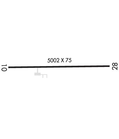
| Lat: N 3625.9 Long: W 08125.1 Elev: 3178 Var: +07 Longest Runway: 5002 | ||
| AWOS: 120.67 CTAF: 122.8 | ||
| ||||||||||||||||||||||||||||||||
| ||||||||||||||||||||||||||||||||
| ||||||||||||||||||||||||||||||||
| Rwy | Rwy | |||||||
| 5002x75 | 5002' | 5002x75 | 5002' | 109.35 - 275° | ||||
| Runway ID | Single Wheel | Double Wheel | Double Tandem Wheel | Dual Double Wheel |
| 10/28 | 35,500 | 50,500 | N/A | N/A |
| These numbers are Advisory and are not limits. The Airport Manager should have more accurate Weight Limits | ||||
 Airport Diagram might not be current. | |
| Facility Name: | ASHE COUNTY |
| City Name: | JEFFERSON |
| County: | ASHE |
| State abbrev: | NC |
| State Name: | NORTH CAROLINA |
| Ownership: | PUBLICLY OWNED |
| Use: | OPEN TO THE PUBLIC |
| Owner's Name: | ASHE COUNTY |
| Address: | 150 GOVERNMENT CIRCLE, SUITE 2500 |
| JEFFERSON, NC 28640 | |
| Owner's Phone: | 336-846-5501 |
| Manager's Name: | ERIC PAYNE |
| Address: | 639 AIRPORT ROAD |
| JEFFERSON, NC 28640 | |
| Phone: | 336-982-5144 |
| FAA Region: | SOUTHERN |
| FAA Field Office: | MEM |
| Date | Sunrise | Sunset |
|---|---|---|
| 06/08/26 Monday | 6:07 | 20:42 |
| 06/09/26 Tuesday | 6:07 | 20:43 |
| 06/10/26 Wednesday | 6:07 | 20:43 |
| 06/11/26 Thursday | 6:07 | 20:44 |
| 06/12/26 Friday | 6:07 | 20:44 |
| 06/13/26 Saturday | 6:07 | 20:44 |
| 06/14/26 Sunday | 6:07 | 20:45 |
| 06/15/26 Monday | 6:07 | 20:45 |
| 06/16/26 Tuesday | 6:07 | 20:46 |
| 06/17/26 Wednesday | 6:07 | 20:46 |
| 06/18/26 Thursday | 6:07 | 20:46 |
| 06/19/26 Friday | 6:08 | 20:46 |
| 06/20/26 Saturday | 6:08 | 20:47 |
| 06/21/26 Sunday | 6:08 | 20:47 |
| Airport Attendance Schedule | 7 Days A Week 0830-1630; UNATNDD THANKSGIVING AND CHRISTMAS. |
| Airport Status | OPERATIONAL (This Status can change at any time - please check NOTAMS) |
| Airport Lighting Schedule | ACTVT REIL RWY 28; PAPI RWY 28; MIRL RWY 10/28 - CTAF. |
| Airport Storage Available | Tie Downs |
| Extra Services Available | Crop Dusting, Flight Instruction, Aircraft Rental |
| Wind Indicator | YES - (lighted) |
| Control Tower | NO |
| CTAF Frequency | 122.800 |
| Unicom Frequency | 122.800 |
| Rotating Beacon Color | WG |
| Segmented Circle | YES |
| Landing Fee | NO |
| Airport Inspected | STATE - performed by STATE AERONAUTICAL PERSONNEL |
| Inspection Date | 07/28/2023 |
| Type of Fuel Available | Grade 100LL, JET A-1 (icing inhibitor, freeze point -50C); -1024 HR JET A FUEL AVBL WITH CREDIT CARD. |
| Airframe Repair Service | MAJOR |
| Power Plant Repair Service | MAJOR |
| Latitude | N3625.9 |
| Longitude | W08125.1 (ESTIMATED) |
| Arpt Elevation | 3177ft (SURVEYED) |
| Magnetic Variation | 07W |
| 3 miles E | of JEFFERSON |
| Traffic Pattern Altitude | |
| Sectional Chart | CINCINNATI |
| Operations (Reported) | Yearly | Avg. Daily |
|---|---|---|
| General Aviation Transient | 0 | 0 |
| General Aviation Local | 0 | 0 |
| Air Taxi | 0 | 0 |
| Commerical | 0 | 0 |
| Commuter | 0 | 0 |
| Military | 0 | 0 |
| Aircraft based on Field | |
|---|---|
| General Aviation Singles | 0 |
| General Aviation Multi | 0 |
| Jet Aircraft | 0 |
| General Aviation Helicopters | 0 |
| Military Aircraft | 0 |
| Gliders | 0 |
| Ultralights | 0 |
| FSS on field | NO |
| FSS tie-in | RALEIGH |
| FSS Phone | 1-800-WX-BRIEF |
| Who issues Notams | GEV |
| Notam D service at airport | YES |
| ARTCC Name | ATLANTA |
| Airport Certification | |
| Aircraft Rescue & Firefighting Index | None |
| Airport of Entry | No |
| Custom Landing Rights | No |
| Joint Civil/Military | No |
| Military Landing rights | YES |
| NATIONAL PLAN OF INTEGRATED AIRPORT SYSTEMS (NPIAS) |
| GRANT AGREEMENTS UNDER FAAP/ADAP/AIP |
| ASSURANCES PURSUANT TO TITLE VI, CIVIL RIGHTS ACT OF 1964 |
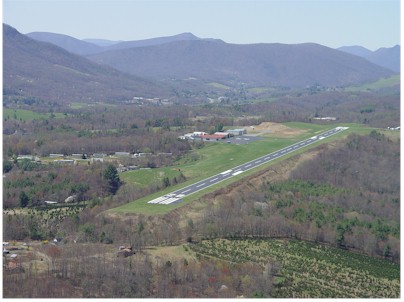
| RISING TRRN ALL QUADS. |
| DEER INVOF ARPT. |
| RWYS 10 & 28 SAFETY AREAS HAVE 100 FT DROP-OFFS 270 FT FM THR. |
| RWY 28 HAS AN UPHILL GRADE. |
| OCNL CROPS AND FARMING EQPT ADJ TO RWY. |
| RWY 28 HAS 100 FT DROP-OFFS 90 FT LEFT AND RIGHT OF CNTRLN. |
| FOR CD CTC ATLANTA ARTCC AT 770-210-7692. |
| COLD TEMPERATURE AIRPORT. ALTITUDE CORRECTION REQUIRED AT OR BELOW -16C. |
Airport Communications & Frequencies:
| |||||||||
| Runway: 10 | Runway: 28 | ||
| Mag heading: | 96° | Mag heading: | 276° |
| Rwy Slope: | -1.81% Down | Rwy Slope: | 1.81% Up |
| Approach: | Approach: | LOC/DME | |
| Pattern: | Left Traffic | Pattern: | Left Traffic |
| Markings: | NONPRECISION INSTRUMENT | Markings: | NONPRECISION INSTRUMENT |
| Marking Condition: | GOOD | Marking Condition: | GOOD |
| Arresting Dev: | Arresting Dev: | ||
| Lat & Long: | N3625.9 W08125.6 | Lat. & Long.: | N3626.0 W08124.6 |
| Elev: | 3177.5 ft. MSL | Elev: | 3086.9 ft. MSL |
| TCH: | TCH: | 48 ft. AGL | |
| Visual Glide Path: | Visual Glide Path: | 3.00 degrees | |
| Displaced Threshold: | No | Displaced Threshold: | No |
| Touchdown Zone: | YES | Touchdown Zone: | YES |
| Touchdown Elev.: | 3177.5 feet | Touchdown Elev.: | 3141.5 feet |
| Visual Glide Slope: | Visual Glide Slope: | 2-Light PAPI on LEFT side of Runway | |
| RVR Equipment: | RVR Equipment: | ||
| RVV Equipment: | NO | RVV Equipment: | NO |
| Approach Lights: | Approach Lights: | ||
| REIL: | NO | REIL: | YES |
| Centerline Lights: | NO | Centerline Lights: | NO |
| Touchdown lights: | NO | Touchdown lights: | NO |
| Runway Category: | Runway with a Visual Approach | Runway Category: | Runway with a Non-precision Approach having visibility minimums greater than 3/4 mile |
| Declared Distances: | Declared Distances: | ||
| Obstructions: | TREES | Obstructions: | |
| Marked: | NOT Marked/Lighted | Marked: | |
| Clearance slope: | 18:1 | Clearance slope: | 34:1 |
| Obstruction height: | 14 feet AGL | Obstruction height: | |
| Dist. from runway: | 464 feet | Dist. from runway: | |
| Centerline offset: | 221 right of centerline | Centerline offset: | |
| Comments: | DUE TO 7 FT TREES 173 FT FM THR OFFSET 93 FT LEFT OF CNTRLN. | Comments: | DUE TO 3 FT BRUSH 49 FT FM THR OFFSET 111 FT RIGHT OF CNTRLN AND 5 FT BRUSH 86 FT FM THR OFFSET 92 FT LEFT OF CNTRLN. |
Thanks for using FltPlan.com
all rights reserved © 1999-2026 by Flight Plan LLC