
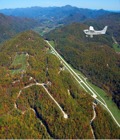
| HEAVEN'S LANDING (PVT) CLAYTON GA |
| |
| Lat: N 3454.9 Long: W 08327.6 Elev: 2724 Var: +05 Longest Runway: 5062 | ||
| |||||
|
| Rwy | Rwy | |||||||
| 5062x50 | 5062' | 5062x50 | 5062' | |||||
| Runway ID | Single Wheel | Double Wheel | Double Tandem Wheel | Dual Double Wheel |
| 05/23 | N/A | N/A | N/A | N/A |
| These numbers are Advisory and are not limits. The Airport Manager should have more accurate Weight Limits | ||||
| FltPlan does not have IFR approach charts available for GE99. |
| Facility Name: | HEAVEN'S LANDING |
| City Name: | CLAYTON |
| County: | RABUN |
| State abbrev: | GA |
| State Name: | GEORGIA |
| Ownership: | PRIVATELY OWNED |
| Use: | PRIVATE |
| Owner's Name: | HEAVEN'S LANDING DEVELOPMENT, LLC |
| Address: | 805 HOOVER TRAIL |
| CLAYTON, GA 30525 | |
| Owner's Phone: | 706-212-0107 |
| Manager's Name: | FRANK WEISSER |
| Address: | 805 HOOVER TRAIL |
| CLAYTON, GA 30525 | |
| Phone: | 706-982-0435 |
| FAA Region: | SOUTHERN |
| FAA Field Office: | ATL |
| Date | Sunrise | Sunset |
|---|---|---|
| 09/24/21 Friday | 7:23 | 19:28 |
| 09/25/21 Saturday | 7:24 | 19:27 |
| 09/26/21 Sunday | 7:25 | 19:25 |
| 09/27/21 Monday | 7:25 | 19:24 |
| 09/28/21 Tuesday | 7:26 | 19:22 |
| 09/29/21 Wednesday | 7:27 | 19:21 |
| 09/30/21 Thursday | 7:28 | 19:20 |
| 10/01/21 Friday | 7:28 | 19:18 |
| 10/02/21 Saturday | 7:29 | 19:17 |
| 10/03/21 Sunday | 7:30 | 19:15 |
| 10/04/21 Monday | 7:31 | 19:14 |
| 10/05/21 Tuesday | 7:31 | 19:13 |
| 10/06/21 Wednesday | 7:32 | 19:11 |
| 10/07/21 Thursday | 7:33 | 19:10 |
| Airport Attendance Schedule | 7 Days A Week 0900-1700 |
| Airport Status | OPERATIONAL (This Status can change at any time - please check NOTAMS) |
| Airport Lighting Schedule | MIRL RWY 05/23 AND PAPI RWY 23 CTAF. |
| Airport Storage Available | NONE |
| Extra Services Available | NONE |
| Wind Indicator | YES - (unlit) |
| Control Tower | NO |
| CTAF Frequency | |
| Unicom Frequency | 122.9 |
| Rotating Beacon Color | |
| Segmented Circle | NO |
| Landing Fee |
| Airport Inspected | 5010-2 PRIVATE USE MAILOUT PROGRAM - performed by the OWNER |
| Inspection Date | Unknown |
| Type of Fuel Available | Grade 100LL, JET A (freeze point -40C) |
| Airframe Repair Service | None |
| Power Plant Repair Service | None |
| Latitude | N3454.9 |
| Longitude | W08327.6 (ESTIMATED) |
| Arpt Elevation | 2724ft (SURVEYED) |
| Magnetic Variation | 05W |
| 4 miles NW | of CLAYTON |
| Traffic Pattern Altitude | |
| Sectional Chart | ATLANTA |
| Operations (Reported) | Yearly | Avg. Daily |
|---|---|---|
| General Aviation Transient | 0 | 0 |
| General Aviation Local | 0 | 0 |
| Air Taxi | 0 | 0 |
| Commerical | 0 | 0 |
| Commuter | 0 | 0 |
| Military | 0 | 0 |
| Aircraft based on Field | |
|---|---|
| General Aviation Singles | 8 |
| General Aviation Multi | 3 |
| Jet Aircraft | 1 |
| General Aviation Helicopters | 0 |
| Military Aircraft | 0 |
| Gliders | 0 |
| Ultralights | 0 |
| FSS on field | NO |
| FSS tie-in | MACON |
| FSS Phone | 1-800-WX-BRIEF |
| Who issues Notams | FDC |
| Notam D service at airport | No |
| ARTCC Name | ATLANTA |
| Airport Certification | |
| Aircraft Rescue & Firefighting Index | None |
| Airport of Entry | No |
| Custom Landing Rights | No |
| Joint Civil/Military | No |
| Military Landing rights | No |
| MOUNTAINOUS TERRAIN ALL QUADRANTS. |
| FOR CD CTC ATLANTA ARTCC AT 770-210-7692. |
| Runway: 05 | Runway: 23 | ||
| Mag heading: | N/A | Mag heading: | N/A |
| Rwy Slope: | .97% Up | Rwy Slope: | -.97% Down |
| Approach: | Approach: | ||
| Pattern: | Right Traffic | Pattern: | Left Traffic |
| Markings: | NONSTANDARD | Markings: | NONSTANDARD |
| Marking Condition: | GOOD; RWY END MARKINGS NSTD SIZE. | Marking Condition: | GOOD; RWY END MARKINGS NSTD SIZE. |
| Arresting Dev: | Arresting Dev: | ||
| Lat & Long: | N3454.5 W08327.9 | Lat. & Long.: | N3455.2 W08327.2 |
| Elev: | 2686.0 ft. MSL | Elev: | 2735.0 ft. MSL |
| TCH: | TCH: | 63 ft. AGL | |
| Visual Glide Path: | Visual Glide Path: | 4.00 degrees | |
| Displaced Threshold: | No | Displaced Threshold: | No |
| Touchdown Zone: | YES | Touchdown Zone: | YES |
| Touchdown Elev.: | 2686.0 feet | Touchdown Elev.: | 2735.0 feet |
| Visual Glide Slope: | Visual Glide Slope: | 2-Light PAPI on LEFT side of Runway | |
| RVR Equipment: | RVR Equipment: | ||
| RVV Equipment: | NO | RVV Equipment: | NO |
| Approach Lights: | Approach Lights: | ||
| REIL: | NO | REIL: | NO |
| Centerline Lights: | NO | Centerline Lights: | NO |
| Touchdown lights: | NO | Touchdown lights: | NO |
| Runway Category: | Runway with a Visual Approach | Runway Category: | Runway with a Non-precision Approach |
| Declared Distances: | Declared Distances: |
Thanks for using FltPlan.com
all rights reserved © 1999-2021 by Flight Plan LLC