
| GRUNDY MUNI (CLOSED) GRUNDY VA |
| |
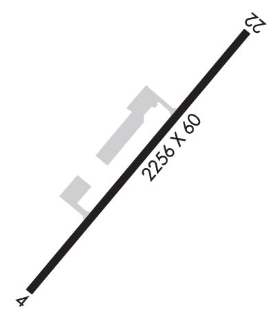
| Lat: N 3713.9 Long: W 08207.5 Elev: 2304 Var: +06 Longest Runway: 2256 | ||
| CTAF: 123.0 | ||
| ||
| Rwy | Rwy | |||||||
| 2256x60 | 2256' | 2256x60 | 2256' | |||||
| Runway ID | Single Wheel | Double Wheel | Double Tandem Wheel | Dual Double Wheel |
| These numbers are Advisory and are not limits. The Airport Manager should have more accurate Weight Limits | ||||
| FltPlan does not have IFR approach charts available for KGDY. |
 Airport Diagram might not be current. | |
| Facility Name: | GRUNDY MUNI |
| City Name: | GRUNDY |
| County: | BUCHANAN |
| State abbrev: | VA |
| State Name: | VIRGINIA |
| Ownership: | PUBLICLY OWNED |
| Use: | OPEN TO THE PUBLIC |
| Owner's Name: | TOWN OF GRUNDY |
| Address: | 1103 PLAZA DRIVE, SUITE D |
| GRUNDY, VA 24614 | |
| Owner's Phone: | 276-935-2551 |
| Manager's Name: | JAMES KEEN |
| Address: | 1103 PLAZA DRIVE, SUITE D |
| GRUNDY, VA 24614 | |
| Phone: | 276-935-2551 |
| FAA Region: | EASTERN |
| FAA Field Office: | DCA |
| Date | Sunrise | Sunset |
|---|---|---|
| 12/14/19 Saturday | 7:34 | 17:12 |
| 12/15/19 Sunday | 7:35 | 17:12 |
| 12/16/19 Monday | 7:36 | 17:13 |
| 12/17/19 Tuesday | 7:36 | 17:13 |
| 12/18/19 Wednesday | 7:37 | 17:13 |
| 12/19/19 Thursday | 7:38 | 17:14 |
| 12/20/19 Friday | 7:38 | 17:14 |
| 12/21/19 Saturday | 7:39 | 17:15 |
| 12/22/19 Sunday | 7:39 | 17:15 |
| 12/23/19 Monday | 7:40 | 17:16 |
| 12/24/19 Tuesday | 7:40 | 17:16 |
| 12/25/19 Wednesday | 7:40 | 17:17 |
| 12/26/19 Thursday | 7:41 | 17:17 |
| 12/27/19 Friday | 7:41 | 17:18 |
| Airport Attendance Schedule | UNATTENDED |
| Airport Status | OPERATIONAL (This Status can change at any time - please check NOTAMS) |
| Airport Lighting Schedule | ACTVT MIRL RY 04/22 - CTAF; HIGH INTSTY ONLY. |
| Airport Storage Available | Tie Downs |
| Extra Services Available | NONE |
| Wind Indicator | YES - (unlit) |
| Control Tower | NO |
| CTAF Frequency | 123.000 |
| Unicom Frequency | 123.000 |
| Rotating Beacon Color | CLEAR-GREEN (Light Land Airport) |
| Segmented Circle | NO |
| Landing Fee | NO |
| Airport Inspected | STATE - performed by STATE AERONAUTICAL PERSONNEL |
| Inspection Date | 07/19/2018 |
| Type of Fuel Available | None |
| Airframe Repair Service | NONE |
| Power Plant Repair Service | NONE |
| Latitude | N3713.9 |
| Longitude | W08207.5 (ESTIMATED) |
| Arpt Elevation | 2304ft (SURVEYED) |
| Magnetic Variation | 06W |
| 3 miles SW | of GRUNDY |
| Traffic Pattern Altitude | |
| Sectional Chart | CINCINNATI |
| Operations (Reported) | Yearly | Avg. Daily |
|---|---|---|
| General Aviation Transient | 380 | 1 |
| General Aviation Local | 3792 | 10 |
| Air Taxi | 0 | 0 |
| Commerical | 0 | 0 |
| Commuter | 0 | 0 |
| Military | 0 | 0 |
| Aircraft based on Field | |
|---|---|
| General Aviation Singles | 11 |
| General Aviation Multi | 1 |
| Jet Aircraft | 0 |
| General Aviation Helicopters | 0 |
| Military Aircraft | 0 |
| Gliders | 0 |
| Ultralights | 0 |
| FSS on field | NO |
| FSS tie-in | LEESBURG |
| FSS Phone | 1-800-WX-BRIEF |
| Who issues Notams | DCA |
| Notam D service at airport | YES |
| ARTCC Name | INDIANAPOLIS |
| Airport Certification | |
| Aircraft Rescue & Firefighting Index | None |
| Airport of Entry | No |
| Custom Landing Rights | No |
| Joint Civil/Military | No |
| Military Landing rights | YES |
| NATIONAL PLAN OF INTEGRATED AIRPORT SYSTEMS (NPIAS) |
| GRANT AGREEMENTS UNDER FAAP/ADAP/AIP |
| ASSURANCES PURSUANT TO TITLE VI, CIVIL RIGHTS ACT OF 1964 |
| PAY PHONE AT AIRPORT 276-935-8022. |
| WILDLIFE INVOF ARPT. |
| FOR CD CTC INDIANAPOLIS ARTCC AT 317-247-2411. |
| Runway: 04 | Runway: 22 | ||
| Mag heading: | 43° | Mag heading: | 223° |
| Rwy Slope: | .00% | Rwy Slope: | .00% |
| Approach: | Approach: | ||
| Pattern: | Left Traffic | Pattern: | Left Traffic |
| Markings: | BASIC | Markings: | BASIC |
| Marking Condition: | FAIR | Marking Condition: | FAIR |
| Arresting Dev: | Arresting Dev: | ||
| Lat & Long: | N3713.8 W08207.6 | Lat. & Long.: | N3714.1 W08207.4 |
| Elev: | 2304.0 ft. MSL | Elev: | 2304.0 ft. MSL |
| TCH: | TCH: | ||
| Visual Glide Path: | Visual Glide Path: | ||
| Displaced Threshold: | No | Displaced Threshold: | No |
| Touchdown Zone: | YES | Touchdown Zone: | YES |
| Touchdown Elev.: | 2304.0 feet | Touchdown Elev.: | 2304.0 feet |
| Visual Glide Slope: | SYSTEM OF PANELS ON LEFT SIDE OF RUNWAY (May NOT Be Lighted); FADED BUT USABLE. | Visual Glide Slope: | SYSTEM OF PANELS ON LEFT SIDE OF RUNWAY (May NOT Be Lighted); FADED BUT USBL. |
| RVR Equipment: | RVR Equipment: | ||
| RVV Equipment: | NO | RVV Equipment: | NO |
| Approach Lights: | Approach Lights: | ||
| REIL: | NO | REIL: | NO |
| Centerline Lights: | NO | Centerline Lights: | NO |
| Touchdown lights: | NO | Touchdown lights: | NO |
| Runway Category: | Runway with a Visual Approach | Runway Category: | Runway with a Visual Approach |
| Declared Distances: | Declared Distances: |
Thanks for using FltPlan.com
all rights reserved © 1999-2019 by Flight Plan LLC
