
| GREENEVILLE-GREENE COUNTY MUNI GREENEVILLE TN |
| |
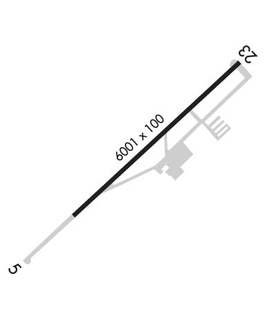
| Lat: N 3611.7 Long: W 08248.7 Elev: 1608 Var: +07 Longest Runway: 6300 | ||
| AWOS: 128.42 CTAF: 122.7 | ||
| ||||||||||||||||||||||||||||||
| ||||||||||||||||||||||||||||||
| ||||||||||||||||||||||||||||||
| Rwy | Rwy | |||||||
| 6300x100 | 6300' | 6300x100 | 6300' | |||||
| Runway ID | Single Wheel | Double Wheel | Double Tandem Wheel | Dual Double Wheel |
| 05/23 | 22,000 | 35,000 | N/A | N/A |
| These numbers are Advisory and are not limits. The Airport Manager should have more accurate Weight Limits | ||||
 Airport Diagram might not be current. | |
| Facility Name: | GREENEVILLE MUNI |
| City Name: | GREENEVILLE |
| County: | GREENE |
| State abbrev: | TN |
| State Name: | TENNESSEE |
| Ownership: | PUBLICLY OWNED |
| Use: | OPEN TO THE PUBLIC |
| Owner's Name: | GREENEVILLE MUNI AIRPORT AUTHORITY |
| Address: | 200 N COLLEGE ST |
| GREENEVILLE, TN 37743 | |
| Owner's Phone: | 423-639-7105 |
| Manager's Name: | STEVEN NEESEN |
| Address: | 246 AIRPORT ROAD |
| GREENEVILLE, TN 37745 | |
| Phone: | 423-823-9310 |
| FAA Region: | SOUTHERN |
| FAA Field Office: | MEM |
| Date | Sunrise | Sunset |
|---|---|---|
| 09/24/21 Friday | 7:21 | 19:25 |
| 09/25/21 Saturday | 7:21 | 19:24 |
| 09/26/21 Sunday | 7:22 | 19:23 |
| 09/27/21 Monday | 7:23 | 19:21 |
| 09/28/21 Tuesday | 7:24 | 19:20 |
| 09/29/21 Wednesday | 7:25 | 19:18 |
| 09/30/21 Thursday | 7:25 | 19:17 |
| 10/01/21 Friday | 7:26 | 19:15 |
| 10/02/21 Saturday | 7:27 | 19:14 |
| 10/03/21 Sunday | 7:28 | 19:12 |
| 10/04/21 Monday | 7:29 | 19:11 |
| 10/05/21 Tuesday | 7:29 | 19:09 |
| 10/06/21 Wednesday | 7:30 | 19:08 |
| 10/07/21 Thursday | 7:31 | 19:07 |
| Airport Attendance Schedule | MON-FRI 0730-1730, SUN 1000-1730, SAT 0800-1730; UNATNDD CHRISTMAS AND JULY 4TH; FOR SVC AFT HRS CALL 423-329-2580. |
| Airport Status | OPERATIONAL (This Status can change at any time - please check NOTAMS) |
| Airport Lighting Schedule | |
| Airport Storage Available | Tie Downs, Hanger |
| Extra Services Available | Air Freight, Air Ambulance, Charter, Flight Instruction, Aircraft Rental |
| Wind Indicator | YES - (unlit) |
| Control Tower | NO |
| CTAF Frequency | 122.700 |
| Unicom Frequency | 122.700 |
| Rotating Beacon Color | CLEAR-GREEN (Light Land Airport) |
| Segmented Circle | NO |
| Landing Fee | NO |
| Airport Inspected | STATE - performed by STATE AERONAUTICAL PERSONNEL |
| Inspection Date | 08/28/2019 |
| Type of Fuel Available | Grade 100LL, JET A |
| Airframe Repair Service | MINOR |
| Power Plant Repair Service | MINOR |
| Latitude | N3611.7 |
| Longitude | W08248.7 (ESTIMATED) |
| Arpt Elevation | 1607ft (SURVEYED) |
| Magnetic Variation | 07W |
| 2 miles N | of GREENEVILLE |
| Traffic Pattern Altitude | |
| Sectional Chart | CINCINNATI |
| Operations (Reported) | Yearly | Avg. Daily |
|---|---|---|
| General Aviation Transient | 13700 | 38 |
| General Aviation Local | 16500 | 45 |
| Air Taxi | 7000 | 19 |
| Commerical | 0 | 0 |
| Commuter | 0 | 0 |
| Military | 530 | 1 |
| Aircraft based on Field | |
|---|---|
| General Aviation Singles | 52 |
| General Aviation Multi | 3 |
| Jet Aircraft | 2 |
| General Aviation Helicopters | 1 |
| Military Aircraft | 0 |
| Gliders | 0 |
| Ultralights | 0 |
| FSS on field | NO |
| FSS tie-in | NASHVILLE |
| FSS Phone | 1-800-WX-BRIEF |
| Who issues Notams | BNA |
| Notam D service at airport | YES |
| ARTCC Name | ATLANTA |
| Airport Certification | |
| Aircraft Rescue & Firefighting Index | None |
| Airport of Entry | No |
| Custom Landing Rights | No |
| Joint Civil/Military | No |
| Military Landing rights | YES |
| NATIONAL PLAN OF INTEGRATED AIRPORT SYSTEMS (NPIAS) |
| GRANT AGREEMENTS UNDER FAAP/ADAP/AIP |
| ASSURANCES PURSUANT TO TITLE VI, CIVIL RIGHTS ACT OF 1964 |
| PAEW ADJ RWY & TWY. |
| FOR CD CTC ATLANTA ARTCC AT 770-210-7692. |
| RWY 23 CALM WIND RWY. |
Airport Communications & Frequencies:
| |||||||||||||||||
| Runway: 05 | Runway: 23 | ||
| Mag heading: | 54° | Mag heading: | 234° |
| Rwy Slope: | .05% Up | Rwy Slope: | -.05% Down |
| Approach: | Approach: | ||
| Pattern: | Left Traffic | Pattern: | Right Traffic |
| Markings: | NONPRECISION INSTRUMENT | Markings: | NONPRECISION INSTRUMENT |
| Marking Condition: | GOOD | Marking Condition: | GOOD |
| Arresting Dev: | Arresting Dev: | ||
| Lat & Long: | N3611.4 W08249.2 | Lat. & Long.: | N3612.1 W08248.2 |
| Elev: | 1599.0 ft. MSL | Elev: | 1602.4 ft. MSL |
| TCH: | 40 ft. AGL | TCH: | 42 ft. AGL |
| Visual Glide Path: | 3.00 degrees | Visual Glide Path: | 4.00 degrees |
| Displaced Threshold: | No | Displaced Threshold: | No |
| Touchdown Zone: | YES | Touchdown Zone: | YES |
| Touchdown Elev.: | 1607.5 feet | Touchdown Elev.: | 1606.0 feet |
| Visual Glide Slope: | 2-Light PAPI on LEFT side of Runway | Visual Glide Slope: | 2-Light PAPI on LEFT side of Runway |
| RVR Equipment: | RVR Equipment: | ||
| RVV Equipment: | NO | RVV Equipment: | NO |
| Approach Lights: | Approach Lights: | ||
| REIL: | YES | REIL: | YES |
| Centerline Lights: | NO | Centerline Lights: | NO |
| Touchdown lights: | NO | Touchdown lights: | NO |
| Runway Category: | Runway with a Non-precision Approach having visibility minimums greater than 3/4 mile | Runway Category: | Runway with a Visual Approach |
| Declared Distances: | Declared Distances: | ||
| Obstructions: | Obstructions: | TREE | |
| Marked: | Marked: | NOT Marked/Lighted | |
| Clearance slope: | 34:1 | Clearance slope: | 18:1 |
| Obstruction height: | Obstruction height: | 189 feet AGL | |
| Dist. from runway: | Dist. from runway: | 3731 feet | |
| Centerline offset: | Centerline offset: | 290 feet left of centerline | |
| Comments: | Comments: |
Thanks for using FltPlan.com
all rights reserved © 1999-2021 by Flight Plan LLC


