
| GUTHRIE COUNTY RGNL GUTHRIE CENTER IA |
| |
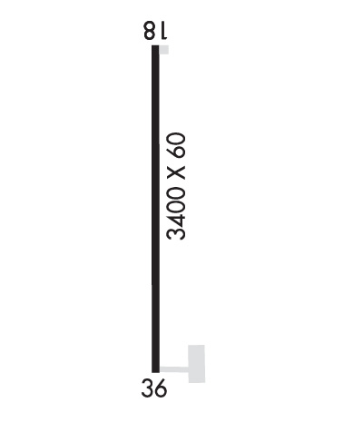
| Lat: N 4141.2 Long: W 09426.1 Elev: 1221 Var: -03 Longest Runway: 3400 | ||
| CTAF: 122.8 | ||
| ||||||||||||||||||||||||||||||||||||||||||||
| ||||||||||||||||||||||||||||||||||||||||||||
| Rwy | Rwy | |||||||
| 3400x60 | 3400' | 3400x60 | 3400' | |||||
| Runway ID | Single Wheel | Double Wheel | Double Tandem Wheel | Dual Double Wheel |
| 18/36 | N/A | N/A | N/A | N/A |
| These numbers are Advisory and are not limits. The Airport Manager should have more accurate Weight Limits | ||||
 Airport Diagram might not be current. | |
| Facility Name: | GUTHRIE COUNTY RGNL |
| City Name: | GUTHRIE CENTER |
| County: | GUTHRIE |
| State abbrev: | IA |
| State Name: | IOWA |
| Ownership: | PUBLICLY OWNED |
| Use: | OPEN TO THE PUBLIC |
| Owner's Name: | GUTHRIE CO REGIONAL ARPT AUTH |
| Address: | PO BOX 37 |
| GUTHRIE CENTER, IA 50115 | |
| Owner's Phone: | 641-332-2190 |
| Manager's Name: | MARSHALL BURGESS |
| Address: | 208 SW 2ND STREET, P.O. BOX 34 |
| PANORA, IA 50216 | |
| Phone: | 641-332-2365; ALT NUMBER 641-757-2046 |
| FAA Region: | CENTRAL |
| FAA Field Office: | NONE |
| Date | Sunrise | Sunset |
|---|---|---|
| 09/24/21 Friday | 7:07 | 19:12 |
| 09/25/21 Saturday | 7:08 | 19:10 |
| 09/26/21 Sunday | 7:09 | 19:08 |
| 09/27/21 Monday | 7:10 | 19:07 |
| 09/28/21 Tuesday | 7:11 | 19:05 |
| 09/29/21 Wednesday | 7:12 | 19:03 |
| 09/30/21 Thursday | 7:13 | 19:02 |
| 10/01/21 Friday | 7:14 | 19:00 |
| 10/02/21 Saturday | 7:15 | 18:58 |
| 10/03/21 Sunday | 7:16 | 18:56 |
| 10/04/21 Monday | 7:18 | 18:55 |
| 10/05/21 Tuesday | 7:19 | 18:53 |
| 10/06/21 Wednesday | 7:20 | 18:51 |
| 10/07/21 Thursday | 7:21 | 18:50 |
| Airport Attendance Schedule | UNATTENDED |
| Airport Status | OPERATIONAL (This Status can change at any time - please check NOTAMS) |
| Airport Lighting Schedule | MIRL RY 18/36 PRESET LOW INTST; TO INCR INTST & ACTVT PAPI RYS 18 & 36; REIL RYS 18 & 36 - CTAF. |
| Airport Storage Available | Tie Downs |
| Extra Services Available | NONE |
| Wind Indicator | YES - (lighted) |
| Control Tower | NO |
| CTAF Frequency | 122.800 |
| Unicom Frequency | 122.800 |
| Rotating Beacon Color | CLEAR-GREEN (Light Land Airport) |
| Segmented Circle | NO |
| Landing Fee |
| Airport Inspected | STATE - performed by STATE AERONAUTICAL PERSONNEL |
| Inspection Date | 12/21/2020 |
| Type of Fuel Available | Grade 100LL |
| Airframe Repair Service | None |
| Power Plant Repair Service | None |
| Latitude | N4141.2 |
| Longitude | W09426.1 (ESTIMATED) |
| Arpt Elevation | 1220ft (SURVEYED) |
| Magnetic Variation | 03E |
| 3 miles E | of GUTHRIE CENTER |
| Traffic Pattern Altitude | |
| Sectional Chart | OMAHA |
| Operations (Reported) | Yearly | Avg. Daily |
|---|---|---|
| General Aviation Transient | 1847 | 5 |
| General Aviation Local | 1403 | 4 |
| Air Taxi | 0 | 0 |
| Commerical | 0 | 0 |
| Commuter | 0 | 0 |
| Military | 0 | 0 |
| Aircraft based on Field | |
|---|---|
| General Aviation Singles | 11 |
| General Aviation Multi | 2 |
| Jet Aircraft | 0 |
| General Aviation Helicopters | 0 |
| Military Aircraft | 0 |
| Gliders | 0 |
| Ultralights | 0 |
| FSS on field | NO |
| FSS tie-in | FORT DODGE |
| FSS Phone | 1-800-WX-BRIEF |
| Who issues Notams | FOD |
| Notam D service at airport | YES |
| ARTCC Name | MINNEAPOLIS |
| Airport Certification | |
| Aircraft Rescue & Firefighting Index | None |
| Airport of Entry | No |
| Custom Landing Rights | No |
| Joint Civil/Military | No |
| Military Landing rights | No |
| NATIONAL PLAN OF INTEGRATED AIRPORT SYSTEMS (NPIAS) |
| FOR CD CTC DES MOINES ATCT AT 515-974- 8016. |
Airport Communications & Frequencies:
| ||||||||||||||
| Runway: 18 | Runway: 36 | ||
| Mag heading: | 177° | Mag heading: | 357° |
| Rwy Slope: | -.06% Down | Rwy Slope: | .06% Up |
| Approach: | Approach: | ||
| Pattern: | Left Traffic | Pattern: | Left Traffic |
| Markings: | NONPRECISION INSTRUMENT | Markings: | NONPRECISION INSTRUMENT |
| Marking Condition: | GOOD | Marking Condition: | GOOD |
| Arresting Dev: | Arresting Dev: | ||
| Lat & Long: | N4141.5 W09426.1 | Lat. & Long.: | N4140.9 W09426.1 |
| Elev: | 1220.5 ft. MSL | Elev: | 1218.6 ft. MSL |
| TCH: | 33 ft. AGL | TCH: | 29 ft. AGL |
| Visual Glide Path: | 3.25 degrees | Visual Glide Path: | 3.25 degrees |
| Displaced Threshold: | No | Displaced Threshold: | No |
| Touchdown Zone: | YES | Touchdown Zone: | YES |
| Touchdown Elev.: | 1220.5 feet | Touchdown Elev.: | 1220.1 feet |
| Visual Glide Slope: | 2-Light PAPI on LEFT side of Runway | Visual Glide Slope: | 2-Light PAPI on LEFT side of Runway; PAPI UNUSBL BYD 8 DEGS RIGHT OF CNTRLN. |
| RVR Equipment: | RVR Equipment: | ||
| RVV Equipment: | NO | RVV Equipment: | NO |
| Approach Lights: | Approach Lights: | ||
| REIL: | YES | REIL: | YES |
| Centerline Lights: | NO | Centerline Lights: | NO |
| Touchdown lights: | NO | Touchdown lights: | NO |
| Runway Category: | Runway with a Non-precision Approach | Runway Category: | Runway with a Non-precision Approach |
| Declared Distances: | Declared Distances: | ||
| Obstructions: | BRUSH | Obstructions: | POLE |
| Marked: | NOT Marked/Lighted | Marked: | NOT Marked/Lighted |
| Clearance slope: | 22:1 | Clearance slope: | 26:1 |
| Obstruction height: | 10 feet AGL | Obstruction height: | 20 feet AGL |
| Dist. from runway: | 425 feet | Dist. from runway: | 727 feet |
| Centerline offset: | 5 right of centerline | Centerline offset: | 256 |
| Comments: | Comments: |
Thanks for using FltPlan.com
all rights reserved © 1999-2021 by Flight Plan LLC