
| GILLETTE-CAMPBELL COUNTY GILLETTE WY |
| |
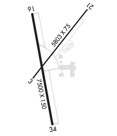
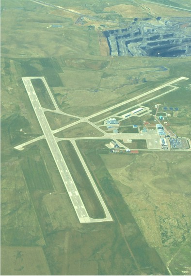
| Lat: N 4420.9 Long: W 10532.4 Elev: 4365 Var: -09 Longest Runway: 7501 | ||
| AWOS: 124.17 CTAF: 118.50 | ||
| ||||||||||||||||||||||||||||||||
| ||||||||||||||||||||||||||||||||
| ||||||||||||||||||||||||||||||||
| Rwy | Rwy | |||||||
| 5804x75 | 5804' | 5804x75 | 5804' | |||||
| 7501x150 | 7501' | 7501x150 | 7501' | 110.10 - 340° | ||||
| Runway ID | Single Wheel | Double Wheel | Double Tandem Wheel | Dual Double Wheel |
| 03/21 | 40,000 | 60,000 | N/A | N/A |
| 16/34 | 70,000 | 110,000 | 160,000 | N/A |
| These numbers are Advisory and are not limits. The Airport Manager should have more accurate Weight Limits | ||||
 Airport Diagram might not be current. | |
| Facility Name: | NORTHEAST WYOMING RGNL |
| City Name: | GILLETTE |
| County: | CAMPBELL |
| State abbrev: | WY |
| State Name: | WYOMING |
| Ownership: | PUBLICLY OWNED |
| Use: | OPEN TO THE PUBLIC |
| Owner's Name: | CAMPBELL CO |
| Address: | 307 TERMINAL LOOP, SUITE 108 |
| GILLETTE, WY 82716 | |
| Owner's Phone: | 307-686-1042 |
| Manager's Name: | TODD CHATFIELD |
| Address: | 307 TERMINAL LOOP, SUITE 108 |
| GILLETTE, WY 82716 | |
| Phone: | 307-686-1042; 307-686-1042 |
| FAA Region: | NORTHWEST MOUNTAIN |
| FAA Field Office: | DEN |
| Date | Sunrise | Sunset |
|---|---|---|
| 06/08/26 Monday | 5:18 | 20:44 |
| 06/09/26 Tuesday | 5:18 | 20:45 |
| 06/10/26 Wednesday | 5:18 | 20:46 |
| 06/11/26 Thursday | 5:18 | 20:46 |
| 06/12/26 Friday | 5:17 | 20:47 |
| 06/13/26 Saturday | 5:17 | 20:47 |
| 06/14/26 Sunday | 5:17 | 20:48 |
| 06/15/26 Monday | 5:17 | 20:48 |
| 06/16/26 Tuesday | 5:17 | 20:48 |
| 06/17/26 Wednesday | 5:17 | 20:49 |
| 06/18/26 Thursday | 5:17 | 20:49 |
| 06/19/26 Friday | 5:18 | 20:49 |
| 06/20/26 Saturday | 5:18 | 20:50 |
| 06/21/26 Sunday | 5:18 | 20:50 |
| Airport Attendance Schedule | 7 Days A Week 0500-0000 |
| Airport Status | OPERATIONAL (This Status can change at any time - please check NOTAMS) |
| Airport Lighting Schedule | ACTVT MALSR RWY 34; REILS RWYS 03, 16, &21; HIRL RWY 16/34; MIRL RWY 03/21 - CTAF. SEQUENCE FLASHERS RWY 34 AVBL ON HIGH SETTING ONLY. PAPI RWYS 03, 16, 21, 34 OPR CONSLY. |
| Airport Storage Available | Tie Downs, Hanger |
| Extra Services Available | Air Freight, Cargo Handling, Charter, Flight Instruction, Aircraft Rental, Aircraft Sales, Annual Surveying |
| Wind Indicator | YES - (lighted) |
| Control Tower | NO |
| CTAF Frequency | 118.500 |
| Unicom Frequency | 122.950 |
| Rotating Beacon Color | WG |
| Segmented Circle | YES |
| Landing Fee | NO |
| Airport Inspected | FEDERAL - performed by FAA AIRPORTS FIELD PERSONNEL |
| Inspection Date | 01/28/2026 |
| Type of Fuel Available | Grade 100LL, JET A (freeze point -40C), JET A; -10FUEL AVBL H24 VIA CREDIT CARD. |
| Airframe Repair Service | NONE |
| Power Plant Repair Service | NONE |
| Latitude | N4420.9 |
| Longitude | W10532.4 (ESTIMATED) |
| Arpt Elevation | 4365ft (SURVEYED) |
| Magnetic Variation | 09E |
| 4 miles NW | of GILLETTE |
| Traffic Pattern Altitude | 800; TPA: 800 FT AGL LGT ACFT, 1200 FT AGL LRG ACFT. |
| Sectional Chart | CHEYENNE |
| Operations (Reported) | Yearly | Avg. Daily |
|---|---|---|
| General Aviation Transient | 0 | 0 |
| General Aviation Local | 0 | 0 |
| Air Taxi | 0 | 0 |
| Commerical | 0 | 0 |
| Commuter | 0 | 0 |
| Military | 0 | 0 |
| Aircraft based on Field | |
|---|---|
| General Aviation Singles | 0 |
| General Aviation Multi | 0 |
| Jet Aircraft | 0 |
| General Aviation Helicopters | 0 |
| Military Aircraft | 0 |
| Gliders | 0 |
| Ultralights | 0 |
| FSS on field | NO |
| FSS tie-in | CASPER |
| FSS Phone | 1-800-WX-BRIEF |
| Who issues Notams | GCC |
| Notam D service at airport | YES |
| ARTCC Name | DENVER |
| Airport Certification | AIRPORT RECEIVING SCHEDULED AIR CARRIER SERVICE FROM CARRIERS CERTIFICATED BY THE CIVIL AERONAUTICS BOARD; PPR UNSKED ACR OPNS WITH MORE THAN 30 PSGR SEATS CALL AMGR 307-686-1042. |
| Aircraft Rescue & Firefighting Index | AIRPORT HAS A CERTIFICATE UNDER CFR PART 139 |
| Airport of Entry | No |
| Custom Landing Rights | No |
| Joint Civil/Military | No |
| Military Landing rights | YES |
| NATIONAL PLAN OF INTEGRATED AIRPORT SYSTEMS (NPIAS) |
| GRANT AGREEMENTS UNDER FAAP/ADAP/AIP |
| ASSURANCES PURSUANT TO TITLE VI, CIVIL RIGHTS ACT OF 1964 |
| OPN ON UNPAVED SFCS PROHIBITED. |
| AFT HRS OPS CTC - 307-257-3137 |
| MINING/BLASTING OPNS 1/2 MILE N OF AOA DURG DALGT HRS. |
| BIRDS INVOF ARPT. |
| CONDS UNMON. |
| RWY 03/2 1 PCR VALUE: 240/R/D/W/T |
| RWY 16/3 4 PCR VALUE: 580/R/D/W/T |
Airport Communications & Frequencies:
| |||||||||
| Runway: 03 | Runway: 21 | ||
| Mag heading: | 29° | Mag heading: | 209° |
| Rwy Slope: | -.45% Down | Rwy Slope: | .45% Up |
| Approach: | Approach: | ||
| Pattern: | Left Traffic | Pattern: | Left Traffic |
| Markings: | NONPRECISION INSTRUMENT | Markings: | NONPRECISION INSTRUMENT |
| Marking Condition: | GOOD | Marking Condition: | GOOD |
| Arresting Dev: | Arresting Dev: | ||
| Lat & Long: | N4420.7 W10532.6 | Lat. & Long.: | N4421.5 W10531.8 |
| Elev: | 4343.0 ft. MSL | Elev: | 4317.0 ft. MSL |
| TCH: | 41 ft. AGL | TCH: | 39 ft. AGL |
| Visual Glide Path: | 4.00 degrees | Visual Glide Path: | 4.00 degrees |
| Displaced Threshold: | No | Displaced Threshold: | No |
| Touchdown Zone: | YES | Touchdown Zone: | YES |
| Touchdown Elev.: | 4343.1 feet | Touchdown Elev.: | 4324.9 feet |
| Visual Glide Slope: | 4-Light PAPI on LEFT side of Runway | Visual Glide Slope: | 4-Light PAPI on LEFT side of Runway |
| RVR Equipment: | RVR Equipment: | ||
| RVV Equipment: | NO | RVV Equipment: | NO |
| Approach Lights: | Approach Lights: | ||
| REIL: | YES | REIL: | YES |
| Centerline Lights: | NO | Centerline Lights: | NO |
| Touchdown lights: | NO | Touchdown lights: | NO |
| Runway Category: | Runway with a Visual Approach | Runway Category: | Runway with a Visual Approach |
| Declared Distances: | TORA:5803' TODA:5803' ASDA:5803' LDA:5803' | Declared Distances: | TORA:5803' TODA:5803' ASDA:5803' LDA:5803' |
| Runway: 16 | Runway: 34 | ||
| Mag heading: | 161° | Mag heading: | 341° |
| Rwy Slope: | .37% Up | Rwy Slope: | -.37% Down |
| Approach: | Approach: | ILS/DME | |
| Pattern: | Left Traffic | Pattern: | Left Traffic |
| Markings: | PRECISION INSTRUMENT | Markings: | PRECISION INSTRUMENT |
| Marking Condition: | GOOD | Marking Condition: | GOOD |
| Arresting Dev: | Arresting Dev: | ||
| Lat & Long: | N4421.4 W10532.6 | Lat. & Long.: | N4420.2 W10532.3 |
| Elev: | 4337.0 ft. MSL | Elev: | 4364.9 ft. MSL |
| TCH: | 43 ft. AGL | TCH: | 56 ft. AGL |
| Visual Glide Path: | 3.17 degrees | Visual Glide Path: | 3.20 degrees |
| Displaced Threshold: | No | Displaced Threshold: | No |
| Touchdown Zone: | YES | Touchdown Zone: | YES |
| Touchdown Elev.: | 4337.2 feet | Touchdown Elev.: | 4365.1 feet |
| Visual Glide Slope: | 4-Light PAPI on LEFT side of Runway | Visual Glide Slope: | 4-Light PAPI on LEFT side of Runway |
| RVR Equipment: | RVR Equipment: | ||
| RVV Equipment: | NO | RVV Equipment: | NO |
| Approach Lights: | Approach Lights: | MALSR - 1,400 foot medium intensity approach lighting system with runway alignment indicator lights | |
| REIL: | YES | REIL: | NO |
| Centerline Lights: | NO | Centerline Lights: | NO |
| Touchdown lights: | NO | Touchdown lights: | NO |
| Runway Category: | Runway with a Non-precision Approach having visibility minimums greater than 3/4 mile | Runway Category: | Precision Instrument Runway |
| Declared Distances: | TORA:7500' TODA:7500' ASDA:7500' LDA:7500' | Declared Distances: | TORA:7500' TODA:7500' ASDA:7500' LDA:7500' |
| Obstructions: | ROAD; +56 FT BLDG 1600 FT FM RWY END 568 FT R. | Obstructions: | PLINE |
| Marked: | NOT Marked/Lighted | Marked: | NOT Marked/Lighted |
| Clearance slope: | 25:1 | Clearance slope: | 30:1 |
| Obstruction height: | 56 feet AGL | Obstruction height: | 312 feet AGL |
| Dist. from runway: | 1600 feet | Dist. from runway: | 9732 feet |
| Centerline offset: | Centerline offset: | 1351 feet right of centerline | |
| Comments: | Comments: |
Thanks for using FltPlan.com
all rights reserved © 1999-2026 by Flight Plan LLC