
| HUTSON FIELD GRAFTON ND |
| |
| Lat: N 4824.3 Long: W 09722.3 Elev: 825 Var: -06 Longest Runway: 4074 | ||
| AWOS: 118.62 CTAF: 122.8 | ||
| ||||||||||||||||||||||||||||||||||||||||||||
| ||||||||||||||||||||||||||||||||||||||||||||
| ||||||||||||||||||||||||||||||||||||||||||||
| Rwy | Rwy | |||||||
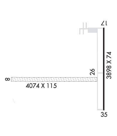
| 4074x115 | 4074' | 4074x115 | 4074' | |||||
| 3898x74 | 3898' | 3898x74 | 3898' | |||||
| Runway ID | Single Wheel | Double Wheel | Double Tandem Wheel | Dual Double Wheel |
| 08/26 | N/A | N/A | N/A | N/A |
| 17/35 | 12,500 | N/A | N/A | N/A |
| These numbers are Advisory and are not limits. The Airport Manager should have more accurate Weight Limits | ||||
 Airport Diagram might not be current. | |
| Facility Name: | HUTSON FLD |
| City Name: | GRAFTON |
| County: | WALSH |
| State abbrev: | ND |
| State Name: | NORTH DAKOTA |
| Ownership: | PUBLICLY OWNED |
| Use: | OPEN TO THE PUBLIC |
| Owner's Name: | GRAFTON ARPT AUTH; CHAIRMAN ARPT AUTH DON HUTSON. |
| Address: | PO BOX 578 |
| GRAFTON, ND 58237 | |
| Owner's Phone: | 701-352-0271 |
| Manager's Name: | ANDY TIBERT |
| Address: | 15182 HWY 17 |
| GRAFTON, ND 58237 | |
| Phone: | 701-352-0271; APT MGRS CELL NUMBER 701-520-9174. |
| FAA Region: | GREAT LAKES |
| FAA Field Office: | DMA |
| Date | Sunrise | Sunset |
|---|---|---|
| 09/24/21 Friday | 7:19 | 19:24 |
| 09/25/21 Saturday | 7:20 | 19:21 |
| 09/26/21 Sunday | 7:21 | 19:19 |
| 09/27/21 Monday | 7:23 | 19:17 |
| 09/28/21 Tuesday | 7:24 | 19:15 |
| 09/29/21 Wednesday | 7:26 | 19:13 |
| 09/30/21 Thursday | 7:27 | 19:11 |
| 10/01/21 Friday | 7:29 | 19:09 |
| 10/02/21 Saturday | 7:30 | 19:07 |
| 10/03/21 Sunday | 7:31 | 19:05 |
| 10/04/21 Monday | 7:33 | 19:03 |
| 10/05/21 Tuesday | 7:34 | 19:01 |
| 10/06/21 Wednesday | 7:36 | 18:59 |
| 10/07/21 Thursday | 7:37 | 18:57 |
| Airport Attendance Schedule | MON-FRI DALGT, SAT-SUN ON CALL; FOR SVC AFT HRS CALL 701-352-0271/701-520-9174. |
| Airport Status | OPERATIONAL (This Status can change at any time - please check NOTAMS) |
| Airport Lighting Schedule | MIRL RY 17/35 & PAPI RYS 17 & 35 PRESET ON LOW INTST DUSK-2300; TO INCR INTST AFT 2300 ACTVT - CTAF. |
| Airport Storage Available | Tie Downs, Hanger |
| Extra Services Available | Crop Dusting, Flight Instruction |
| Wind Indicator | YES - (lighted) |
| Control Tower | NO |
| CTAF Frequency | 122.800 |
| Unicom Frequency | 122.800 |
| Rotating Beacon Color | CLEAR-GREEN (Light Land Airport) |
| Segmented Circle | NO |
| Landing Fee | NO |
| Airport Inspected | STATE - performed by STATE AERONAUTICAL PERSONNEL |
| Inspection Date | 08/26/2019 |
| Type of Fuel Available | Grade 100LL, JET A (freeze point -40C); -1024-HR SELF- SVC FUEL AVBL WITH CREDIT CARD ONLY. |
| Airframe Repair Service | MINOR |
| Power Plant Repair Service | MINOR |
| Latitude | N4824.3 |
| Longitude | W09722.3 (ESTIMATED) |
| Arpt Elevation | 824ft (SURVEYED) |
| Magnetic Variation | 06E |
| 2 miles ESE | of GRAFTON |
| Traffic Pattern Altitude | |
| Sectional Chart | TWIN CITIES |
| Operations (Reported) | Yearly | Avg. Daily |
|---|---|---|
| General Aviation Transient | 21000 | 58 |
| General Aviation Local | 5000 | 14 |
| Air Taxi | 300 | 1 |
| Commerical | 0 | 0 |
| Commuter | 0 | 0 |
| Military | 50 | 0 |
| Aircraft based on Field | |
|---|---|
| General Aviation Singles | 16 |
| General Aviation Multi | 0 |
| Jet Aircraft | 0 |
| General Aviation Helicopters | 0 |
| Military Aircraft | 0 |
| Gliders | 0 |
| Ultralights | 0 |
| FSS on field | NO |
| FSS tie-in | GRAND FORKS |
| FSS Phone | 1-800-WX-BRIEF |
| Who issues Notams | GFK |
| Notam D service at airport | YES |
| ARTCC Name | MINNEAPOLIS |
| Airport Certification | |
| Aircraft Rescue & Firefighting Index | None |
| Airport of Entry | No |
| Custom Landing Rights | No |
| Joint Civil/Military | No |
| Military Landing rights | YES |
| NATIONAL PLAN OF INTEGRATED AIRPORT SYSTEMS (NPIAS) |
| GRANT AGREEMENTS UNDER FAAP/ADAP/AIP |
| ASSURANCES PURSUANT TO TITLE VI, CIVIL RIGHTS ACT OF 1964 |
| BE ALERT: 3 FT DITCH BTN EAST END 8/26 & 17/35, USE DSGND TWYS. |
| FOR CD CTC MINNEAPOLIS ARTCC AT 651-463-5588. |
| LARGE BIRDS AND DEER ON OR INVOF ARPT. |
| HVY AERIAL SPRAY ACTIVITY MAY-OCT. |
| CONFIRM WINTER CONDS AND SNOW REMOVAL WITH AMGR CALL 701-352-0271/ 701-520-9174. |
| NMRS TSNT FLT TRNG ACTIVITIES. |
| RY 17/35 PARALLEL TWY MARKED WITH REFLECTORS. |
| RY 08/26 CLSD WINTER MONTHS DUE TO LACK OF SNOW REMOVAL |
| RWY 08 HAS +3' DITCH 213' FM THRSHOLD |
| RWY 08/2 6 TURF SOFT WHEN WET & ROUGH DUE TO SPARSE GRASS GROWTH. |
Airport Communications & Frequencies:
| |||||||||||||||||
| Runway: 08 | Runway: 26 | ||
| Mag heading: | 84° | Mag heading: | 264° |
| Rwy Slope: | .00% Up | Rwy Slope: | .00% Down |
| Approach: | Approach: | ||
| Pattern: | Left Traffic | Pattern: | Left Traffic |
| Markings: | Markings: | ||
| Marking Condition: | RWY 08/26 - MKD WITH WHITE DALGT END MKRS. | Marking Condition: | |
| Arresting Dev: | Arresting Dev: | ||
| Lat & Long: | N4824.2 W09723.1 | Lat. & Long.: | N4824.2 W09722.0 |
| Elev: | 820.6 ft. MSL | Elev: | 820.8 ft. MSL |
| TCH: | TCH: | ||
| Visual Glide Path: | Visual Glide Path: | ||
| Displaced Threshold: | No | Displaced Threshold: | No |
| Touchdown Zone: | YES | Touchdown Zone: | YES |
| Touchdown Elev.: | 824.5 feet | Touchdown Elev.: | 824.5 feet |
| Visual Glide Slope: | Visual Glide Slope: | ||
| RVR Equipment: | RVR Equipment: | ||
| RVV Equipment: | NO | RVV Equipment: | NO |
| Approach Lights: | Approach Lights: | ||
| REIL: | NO | REIL: | NO |
| Centerline Lights: | NO | Centerline Lights: | NO |
| Touchdown lights: | NO | Touchdown lights: | NO |
| Runway Category: | Runway with a Visual Approach | Runway Category: | Runway with a Visual Approach |
| Declared Distances: | Declared Distances: |
| Runway: 17 | Runway: 35 | ||
| Mag heading: | 174° | Mag heading: | 354° |
| Rwy Slope: | -.01% Down | Rwy Slope: | .01% Up |
| Approach: | Approach: | ||
| Pattern: | Left Traffic | Pattern: | Left Traffic |
| Markings: | NONPRECISION INSTRUMENT | Markings: | NONPRECISION INSTRUMENT |
| Marking Condition: | FAIR | Marking Condition: | FAIR |
| Arresting Dev: | Arresting Dev: | ||
| Lat & Long: | N4824.6 W09722.0 | Lat. & Long.: | N4824.0 W09722.0 |
| Elev: | 822.2 ft. MSL | Elev: | 821.9 ft. MSL |
| TCH: | 26 ft. AGL | TCH: | 26 ft. AGL |
| Visual Glide Path: | 3.00 degrees | Visual Glide Path: | 3.00 degrees |
| Displaced Threshold: | No | Displaced Threshold: | No |
| Touchdown Zone: | YES | Touchdown Zone: | YES |
| Touchdown Elev.: | 822.3 feet | Touchdown Elev.: | 822.3 feet |
| Visual Glide Slope: | 2-Light PAPI on LEFT side of Runway | Visual Glide Slope: | 2-Light PAPI on LEFT side of Runway |
| RVR Equipment: | RVR Equipment: | ||
| RVV Equipment: | NO | RVV Equipment: | NO |
| Approach Lights: | Approach Lights: | ||
| REIL: | NO | REIL: | NO |
| Centerline Lights: | NO | Centerline Lights: | NO |
| Touchdown lights: | NO | Touchdown lights: | NO |
| Runway Category: | Runway with a Non-precision Approach | Runway Category: | Runway with a Non-precision Approach |
| Declared Distances: | Declared Distances: |
Thanks for using FltPlan.com
all rights reserved © 1999-2021 by Flight Plan LLC
