
| NORTHEAST ALABAMA RGNL GADSDEN AL |
| |
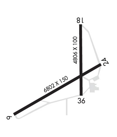
| Lat: N 3358.2 Long: W 08605.5 Elev: 569 Var: +03 Longest Runway: 6802 | ||
| Clr Del: 120.05 AWOS: 127.82 CTAF: 122.72 | ||
| ||||||||||||||||||||||||||||||||||||||||||||
| ||||||||||||||||||||||||||||||||||||||||||||
| ||||||||||||||||||||||||||||||||||||||||||||
| Rwy | Rwy | |||||||
| 6802x150 | 6802' | 6802x150 | 6802' | 108.35 - 243° | ||||
| Runway ID | Single Wheel | Double Wheel | Double Tandem Wheel | Dual Double Wheel |
| 06/24 | 90,000 | 115,000 | 195,000 | N/A |
| These numbers are Advisory and are not limits. The Airport Manager should have more accurate Weight Limits | ||||
 Airport Diagram might not be current. | |
| Facility Name: | NORTHEAST ALABAMA RGNL |
| City Name: | GADSDEN |
| County: | ETOWAH |
| State abbrev: | AL |
| State Name: | ALABAMA |
| Ownership: | PUBLICLY OWNED |
| Use: | OPEN TO THE PUBLIC |
| Owner's Name: | GADSDEN AIRPORT AUTHORITY |
| Address: | 185 IRA GRAY DR. |
| GADSDEN, AL 35904 | |
| Owner's Phone: | 256-442-3313 |
| Manager's Name: | ANTHONY TARVER |
| Address: | 185 IRA GRAY DRIVE |
| GADSDEN, AL 35904 | |
| Phone: | 256-328-4700 |
| FAA Region: | SOUTHERN |
| FAA Field Office: | JAN |
| Date | Sunrise | Sunset |
|---|---|---|
| 06/07/26 Sunday | 5:33 | 19:54 |
| 06/08/26 Monday | 5:33 | 19:54 |
| 06/09/26 Tuesday | 5:33 | 19:55 |
| 06/10/26 Wednesday | 5:33 | 19:55 |
| 06/11/26 Thursday | 5:33 | 19:55 |
| 06/12/26 Friday | 5:33 | 19:56 |
| 06/13/26 Saturday | 5:33 | 19:56 |
| 06/14/26 Sunday | 5:33 | 19:57 |
| 06/15/26 Monday | 5:33 | 19:57 |
| 06/16/26 Tuesday | 5:33 | 19:57 |
| 06/17/26 Wednesday | 5:33 | 19:58 |
| 06/18/26 Thursday | 5:33 | 19:58 |
| 06/19/26 Friday | 5:33 | 19:58 |
| 06/20/26 Saturday | 5:33 | 19:58 |
| Airport Attendance Schedule | MON-FRI 0800-1800, SAT 0900-1700; FOR AFT HRS SVC CALL 256-328-4700, 256-504-8109, OR 256-458-2736 |
| Airport Status | OPERATIONAL (This Status can change at any time - please check NOTAMS) |
| Airport Lighting Schedule | REACTVT REIL RWY 6 & 24; PAPI RWY 6 & 24; HIRL RWY 6/24; TWY LGTS - CTAF. |
| Airport Storage Available | Tie Downs, Hanger |
| Extra Services Available | Avionics, Cargo Handling, Charter, Flight Instruction, Aircraft Rental |
| Wind Indicator | YES - (lighted) |
| Control Tower | NO |
| CTAF Frequency | 122.725 |
| Unicom Frequency | 122.725 |
| Rotating Beacon Color | WG |
| Segmented Circle | YES |
| Landing Fee | NO |
| Airport Inspected | STATE - performed by STATE AERONAUTICAL PERSONNEL |
| Inspection Date | 12/10/2025 |
| Type of Fuel Available | Grade 100LL, JET A-1 (icing inhibitor, freeze point -50C) |
| Airframe Repair Service | MAJOR |
| Power Plant Repair Service | MAJOR |
| Latitude | N3358.2 |
| Longitude | W08605.5 (ESTIMATED) |
| Arpt Elevation | 569ft (SURVEYED) |
| Magnetic Variation | 03W |
| 4 miles SW | of GADSDEN |
| Traffic Pattern Altitude | |
| Sectional Chart | ATLANTA |
| Operations (Reported) | Yearly | Avg. Daily |
|---|---|---|
| General Aviation Transient | 0 | 0 |
| General Aviation Local | 0 | 0 |
| Air Taxi | 0 | 0 |
| Commerical | 0 | 0 |
| Commuter | 0 | 0 |
| Military | 0 | 0 |
| Aircraft based on Field | |
|---|---|
| General Aviation Singles | 0 |
| General Aviation Multi | 0 |
| Jet Aircraft | 0 |
| General Aviation Helicopters | 0 |
| Military Aircraft | 0 |
| Gliders | 0 |
| Ultralights | 0 |
| FSS on field | NO |
| FSS tie-in | ANNISTON |
| FSS Phone | 1-800-WX-BRIEF |
| Who issues Notams | GAD |
| Notam D service at airport | YES |
| ARTCC Name | ATLANTA |
| Airport Certification | |
| Aircraft Rescue & Firefighting Index | None |
| Airport of Entry | No |
| Custom Landing Rights | No |
| Joint Civil/Military | No |
| Military Landing rights | YES |
| NATIONAL PLAN OF INTEGRATED AIRPORT SYSTEMS (NPIAS) |
| GRANT AGREEMENTS UNDER FAAP/ADAP/AIP |
| SURPLUS PROPERTY AGREEMENT UNDER PUBLIC LAW 289 |
| SURPLUS PROPERTY AGREEMENT UNDER REGULATION 16-WAA |
| ASSURANCES PURSUANT TO TITLE VI, CIVIL RIGHTS ACT OF 1964 |
| AGREEMENT UNDER DLAND OR DCLA HAS EXPIRED. |
Airport Communications & Frequencies:
| ||||||||||||||||||
| Runway: 06 | Runway: 24 | ||
| Mag heading: | 64° | Mag heading: | 244° |
| Rwy Slope: | -.29% Down | Rwy Slope: | .29% Up |
| Approach: | Approach: | ILS/DME | |
| Pattern: | Left Traffic | Pattern: | Left Traffic |
| Markings: | PRECISION INSTRUMENT | Markings: | PRECISION INSTRUMENT |
| Marking Condition: | GOOD | Marking Condition: | GOOD |
| Arresting Dev: | Arresting Dev: | ||
| Lat & Long: | N3358.0 W08606.1 | Lat. & Long.: | N3358.5 W08604.9 |
| Elev: | 569.2 ft. MSL | Elev: | 549.3 ft. MSL |
| TCH: | 40 ft. AGL | TCH: | 45 ft. AGL |
| Visual Glide Path: | 3.00 degrees | Visual Glide Path: | 3.00 degrees |
| Displaced Threshold: | No | Displaced Threshold: | No |
| Touchdown Zone: | YES | Touchdown Zone: | YES |
| Touchdown Elev.: | 569.2 feet | Touchdown Elev.: | 560.1 feet |
| Visual Glide Slope: | 4-Light PAPI on LEFT side of Runway | Visual Glide Slope: | 4-Light PAPI on LEFT side of Runway |
| RVR Equipment: | RVR Equipment: | ||
| RVV Equipment: | NO | RVV Equipment: | NO |
| Approach Lights: | Approach Lights: | ||
| REIL: | YES | REIL: | YES |
| Centerline Lights: | NO | Centerline Lights: | NO |
| Touchdown lights: | NO | Touchdown lights: | NO |
| Runway Category: | D | Runway Category: | Precision Instrument Runway |
| Declared Distances: | Declared Distances: | ||
| Obstructions: | TREE | Obstructions: | TREE |
| Marked: | NOT Marked/Lighted | Marked: | NOT Marked/Lighted |
| Clearance slope: | 27:1 | Clearance slope: | 45:1 |
| Obstruction height: | 52 feet AGL | Obstruction height: | 55 feet AGL |
| Dist. from runway: | 1621 feet | Dist. from runway: | 2724 feet |
| Centerline offset: | 222 right of centerline | Centerline offset: | 172 feet left of centerline |
| Comments: | Comments: |
Thanks for using FltPlan.com
all rights reserved © 1999-2026 by Flight Plan LLC
