
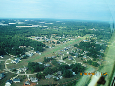
| MALLARDS LANDING (PRIVATE) LOCUST GROVE GA |
| |
| Lat: N 3321.9 Long: W 08409.9 Elev: 837 Var: +02 Longest Runway: 4500G | ||
| ||||||
|
| Rwy | Rwy | |||||||
| 4500x100 | 4500' | 4500x100 | 4500' | |||||
| Runway ID | Single Wheel | Double Wheel | Double Tandem Wheel | Dual Double Wheel |
| 07/25 | N/A | N/A | N/A | N/A |
| These numbers are Advisory and are not limits. The Airport Manager should have more accurate Weight Limits | ||||
| FltPlan does not have IFR approach charts available for GA04. |
| Facility Name: | MALLARDS LANDING |
| City Name: | LOCUST GROVE |
| County: | HENRY |
| State abbrev: | GA |
| State Name: | GEORGIA |
| Ownership: | PRIVATELY OWNED |
| Use: | PRIVATE |
| Owner's Name: | MALLARD'S LANDING HOMEOWNERS ASSOC. |
| Address: | 63 MALLARD LANE |
| LOCUST GROVE, GA 30248 | |
| Owner's Phone: | 404-981-2530 |
| Manager's Name: | GENE VISCELLI |
| Address: | 63 MALLARD LANE |
| LOCUST GROVE, GA 30248 | |
| Phone: | 404-981-2530 |
| FAA Region: | SOUTHERN |
| FAA Field Office: | ATL |
| Date | Sunrise | Sunset |
|---|---|---|
| 06/12/26 Friday | 6:26 | 20:47 |
| 06/13/26 Saturday | 6:26 | 20:47 |
| 06/14/26 Sunday | 6:27 | 20:47 |
| 06/15/26 Monday | 6:27 | 20:48 |
| 06/16/26 Tuesday | 6:27 | 20:48 |
| 06/17/26 Wednesday | 6:27 | 20:48 |
| 06/18/26 Thursday | 6:27 | 20:49 |
| 06/19/26 Friday | 6:27 | 20:49 |
| 06/20/26 Saturday | 6:27 | 20:49 |
| 06/21/26 Sunday | 6:27 | 20:49 |
| 06/22/26 Monday | 6:28 | 20:50 |
| 06/23/26 Tuesday | 6:28 | 20:50 |
| 06/24/26 Wednesday | 6:28 | 20:50 |
| 06/25/26 Thursday | 6:28 | 20:50 |
| Airport Attendance Schedule | UNATTENDED |
| Airport Status | OPERATIONAL (This Status can change at any time - please check NOTAMS) |
| Airport Lighting Schedule | ACTVT LIRL RY 07/25 - 123.7. |
| Airport Storage Available | NONE |
| Extra Services Available | NONE |
| Wind Indicator | YES - (unlit) |
| Control Tower | NO |
| CTAF Frequency | |
| Unicom Frequency | NO GND TRANSMISSION STN. CTAF - 123.700. |
| Rotating Beacon Color | |
| Segmented Circle | YES |
| Landing Fee | NO |
| Airport Inspected | 5010-2 PRIVATE USE MAILOUT PROGRAM - performed by the OWNER |
| Inspection Date | Unknown |
| Type of Fuel Available | None |
| Airframe Repair Service | NONE |
| Power Plant Repair Service | NONE |
| Latitude | N3321.9 |
| Longitude | W08409.9 (ESTIMATED) |
| Arpt Elevation | 837ft (SURVEYED) |
| Magnetic Variation | 02W |
| 3 miles NW | of LOCUST GROVE |
| Traffic Pattern Altitude | |
| Sectional Chart | ATLANTA |
| Operations (Reported) | Yearly | Avg. Daily |
|---|---|---|
| General Aviation Transient | 0 | 0 |
| General Aviation Local | 0 | 0 |
| Air Taxi | 0 | 0 |
| Commerical | 0 | 0 |
| Commuter | 0 | 0 |
| Military | 0 | 0 |
| Aircraft based on Field | |
|---|---|
| General Aviation Singles | 0 |
| General Aviation Multi | 0 |
| Jet Aircraft | 0 |
| General Aviation Helicopters | 0 |
| Military Aircraft | 0 |
| Gliders | 0 |
| Ultralights | 0 |
| FSS on field | NO |
| FSS tie-in | MACON |
| FSS Phone | 1-800-WX-BRIEF |
| Who issues Notams | |
| Notam D service at airport | No |
| ARTCC Name | ATLANTA |
| Airport Certification | |
| Aircraft Rescue & Firefighting Index | None |
| Airport of Entry | No |
| Custom Landing Rights | No |
| Joint Civil/Military | No |
| Military Landing rights | No |
| PPR FROM A RESIDENT TO LAND. RESIDENT CAN PROVIDE GUIDELINES FOR VISITING PILOTS. |
| PREF CALM WIND RWY 25 FOR TKOF WITH A RP FOR NOISE ABATEMENT. ACTV GLIDER OPS ARE DENOTED BY A YELLOW BANNER AT THE MIDFIELD WINDSOCK. THE FULL LEN OF THE RWY IS NOT VISIBLE FROM RWY ENDS. AIRCRAFT DEPARTING RWY 7 MUST VERIFY THAT THE FULL LEN OF THE RWY IS AVBL WHEN DEPARTING. |
| ACTVT THE RWY LIGHTS FOR ALL OPS PR TO ENTERING THE RWY BY KEYING THE MIKE ON THE CTAF - 123.7. |
| FOR CD CTC ATLANTA APCH AT 678-364-6131. |
| PREFLIGHTS AND RUNUPS ON ASPHALT PADS PROVIDED. |
| BE AWARE OF PEDESTRIAN AND GOLF CART ACT IN VINCINITY OG THE ARPT. |
| Runway: 07 | Runway: 25 | ||
| Mag heading: | N/A | Mag heading: | N/A |
| Approach: | Approach: | ||
| Pattern: | Left Traffic | Pattern: | Right Traffic |
| Markings: | Markings: | ||
| Marking Condition: | Marking Condition: | ||
| Arresting Dev: | Arresting Dev: | ||
| Lat & Long: | Lat. & Long.: | ||
| Elev: | N/A | Elev: | N/A |
| TCH: | TCH: | ||
| Visual Glide Path: | Visual Glide Path: | ||
| Displaced Threshold: | No | Displaced Threshold: | No |
| Touchdown Zone: | NO | Touchdown Zone: | NO |
| Touchdown Elev.: | Touchdown Elev.: | ||
| Visual Glide Slope: | Visual Glide Slope: | ||
| RVR Equipment: | RVR Equipment: | ||
| RVV Equipment: | NO | RVV Equipment: | NO |
| Approach Lights: | Approach Lights: | ||
| REIL: | NO | REIL: | NO |
| Centerline Lights: | NO | Centerline Lights: | NO |
| Touchdown lights: | NO | Touchdown lights: | NO |
| Runway Category: | Runway Category: | ||
| Declared Distances: | Declared Distances: |
Thanks for using FltPlan.com
all rights reserved © 1999-2026 by Flight Plan LLC