| OSWEGO COUNTY FULTON NY |
| |
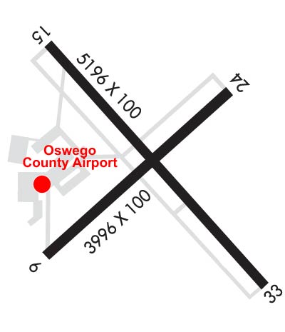
| Lat: N 4321.0 Long: W 07623.3 Elev: 475 Var: +13 Longest Runway: 5196 | ||
| AWOS: 119.27 CTAF: 123.0 | ||
| ||||||||||||||||||||||||||||||||||||||||||||||||||||||||||||||||||||
| ||||||||||||||||||||||||||||||||||||||||||||||||||||||||||||||||||||
| ||||||||||||||||||||||||||||||||||||||||||||||||||||||||||||||||||||
| Rwy | Rwy | |||||||
| 3997x100 | 3997' | 3997x100 | 3997' | |||||
| 5196x100 | 5196' | 5196x100 | 4782' | 110.90 - 329° | ||||
| Runway ID | Single Wheel | Double Wheel | Double Tandem Wheel | Dual Double Wheel |
| 06/24 | 80,000 | 123,000 | N/A | N/A |
| 15/33 | 80,000 | 123,000 | N/A | N/A |
| These numbers are Advisory and are not limits. The Airport Manager should have more accurate Weight Limits | ||||
 Airport Diagram might not be current. | |
| Facility Name: | OSWEGO COUNTY |
| City Name: | FULTON |
| County: | OSWEGO |
| State abbrev: | NY |
| State Name: | NEW YORK |
| Ownership: | PUBLICLY OWNED |
| Use: | OPEN TO THE PUBLIC |
| Owner's Name: | OSWEGO COUNTY ADMIN |
| Address: | 46 E. BRIDGE STRE |
| OSWEGO, NY 13126 | |
| Owner's Phone: | 315-591- 9130 |
| Manager's Name: | BRANDON SCHWERDT |
| Address: | 40 AIRPORT DRIVE, COUNTY ROUTE 176 |
| FULTON, NY 13069 | |
| Phone: | 315-591-9130 |
| FAA Region: | EASTERN |
| FAA Field Office: | NYC |
| Date | Sunrise | Sunset |
|---|---|---|
| 06/08/26 Monday | 5:25 | 20:44 |
| 06/09/26 Tuesday | 5:25 | 20:45 |
| 06/10/26 Wednesday | 5:25 | 20:45 |
| 06/11/26 Thursday | 5:25 | 20:46 |
| 06/12/26 Friday | 5:25 | 20:46 |
| 06/13/26 Saturday | 5:25 | 20:47 |
| 06/14/26 Sunday | 5:24 | 20:47 |
| 06/15/26 Monday | 5:24 | 20:48 |
| 06/16/26 Tuesday | 5:24 | 20:48 |
| 06/17/26 Wednesday | 5:25 | 20:48 |
| 06/18/26 Thursday | 5:25 | 20:49 |
| 06/19/26 Friday | 5:25 | 20:49 |
| 06/20/26 Saturday | 5:25 | 20:49 |
| 06/21/26 Sunday | 5:25 | 20:49 |
| Airport Attendance Schedule | MON-FRI 0730-1600 |
| Airport Status | OPERATIONAL (This Status can change at any time - please check NOTAMS) |
| Airport Lighting Schedule | HIRL RWY 15/33 & PAPI RWY 33 OPR SS-SR AND PRESET LOW INTST; TO INCR INTST AND ACTVT REIL RWY 15/33; HIRL RWY 15/33; MIRL RWY 06/24; PAPI RWY 33 - CTAF. |
| Airport Storage Available | Tie Downs, Hanger |
| Extra Services Available | Flight Instruction, Aircraft Rental |
| Wind Indicator | YES - (lighted) |
| Control Tower | NO |
| CTAF Frequency | 123.000 |
| Unicom Frequency | 123.000 |
| Rotating Beacon Color | WG |
| Segmented Circle | NO |
| Landing Fee | NO |
| Airport Inspected | STATE - performed by STATE AERONAUTICAL PERSONNEL |
| Inspection Date | 07/16/2024 |
| Type of Fuel Available | Grade 100LL, JET A (freeze point -40C) |
| Airframe Repair Service | MAJOR |
| Power Plant Repair Service | MAJOR |
| Latitude | N4321.0 |
| Longitude | W07623.3 (ESTIMATED) |
| Arpt Elevation | 475ft (SURVEYED) |
| Magnetic Variation | 13W |
| 3 miles NE | of FULTON |
| Traffic Pattern Altitude | |
| Sectional Chart | NEW YORK |
| Operations (Reported) | Yearly | Avg. Daily |
|---|---|---|
| General Aviation Transient | 0 | 0 |
| General Aviation Local | 0 | 0 |
| Air Taxi | 0 | 0 |
| Commerical | 0 | 0 |
| Commuter | 0 | 0 |
| Military | 0 | 0 |
| Aircraft based on Field | |
|---|---|
| General Aviation Singles | 0 |
| General Aviation Multi | 0 |
| Jet Aircraft | 0 |
| General Aviation Helicopters | 0 |
| Military Aircraft | 0 |
| Gliders | 0 |
| Ultralights | 0 |
| FSS on field | NO |
| FSS tie-in | BUFFALO |
| FSS Phone | 1-800-WX-BRIEF |
| Who issues Notams | FZY |
| Notam D service at airport | YES |
| ARTCC Name | BOSTON |
| Airport Certification | |
| Aircraft Rescue & Firefighting Index | None |
| Airport of Entry | No |
| Custom Landing Rights | No |
| Joint Civil/Military | No |
| Military Landing rights | YES |
| NATIONAL PLAN OF INTEGRATED AIRPORT SYSTEMS (NPIAS) |
| GRANT AGREEMENTS UNDER FAAP/ADAP/AIP |
| ASSURANCES PURSUANT TO TITLE VI, CIVIL RIGHTS ACT OF 1964 |
| AGREEMENT UNDER DLAND OR DCLA HAS EXPIRED. |
| DURING PERIODS OF SNOW REMOVAL OPNS NOV 1 THRU APR 1 ACFT MUST CTC ARPT ON FREQ 123.0 10 MINS PRIOR TO LDG. |
| RWY 33 DESIGNATED CALM WIND RWY. |
| FOR CD CTC SYRACUSE APCH AT 315-455-6218. |
| AVOID VCNTY OF TWR DUE NORTH ON LAKESHORE. |
| FQT SEAGULL & CANADA GEESE ACTVT ON AND INVOF ARPT DURG POOR WX PERIODS. |
| AIRCRAFT DE-ICING AVAILABLE, CONTACT AIRPORT MANAGER AT 315-591-9130. |
| ATTENDANCE OTHER HOURS - CALL ARPT MGR. |
| DEER AND BIRDS ON OR INVOF ARPT. |
| GRASS CUTTING EQUIPMENT OPS ADJACENT TO ALL OPERATIONA SURFACES DALGHT HRS MAY THRU OCT. |
| RWY CONDITIONS MAY NOT BE MONITORED OR REPORTED WHEN ARPT IS UNATNDD. |
| ULTRLGT ACTIVITY ON AND INVOF ARPT. |
| RWY 06/2 4 PCR VALUE: 31/F/B/W/T |
| RWY 15/3 3 PCR VALUE: 31/F/B/W/T |
Airport Communications & Frequencies:
| ||||||||||||||
| Runway: 06 | Runway: 24 | ||
| Mag heading: | 60° | Mag heading: | 240° |
| Rwy Slope: | .30% Up | Rwy Slope: | -.30% Down |
| Approach: | Approach: | ||
| Pattern: | Left Traffic | Pattern: | Left Traffic |
| Markings: | NONPRECISION INSTRUMENT | Markings: | NONPRECISION INSTRUMENT |
| Marking Condition: | GOOD | Marking Condition: | GOOD |
| Arresting Dev: | Arresting Dev: | ||
| Lat & Long: | N4320.8 W07623.6 | Lat. & Long.: | N4321.2 W07623.0 |
| Elev: | 457.1 ft. MSL | Elev: | 469.1 ft. MSL |
| TCH: | TCH: | ||
| Visual Glide Path: | Visual Glide Path: | ||
| Displaced Threshold: | No | Displaced Threshold: | No |
| Touchdown Zone: | YES | Touchdown Zone: | YES |
| Touchdown Elev.: | 464.3 feet | Touchdown Elev.: | 469.2 feet |
| Visual Glide Slope: | Visual Glide Slope: | ||
| RVR Equipment: | RVR Equipment: | ||
| RVV Equipment: | NO | RVV Equipment: | NO |
| Approach Lights: | Approach Lights: | ||
| REIL: | YES | REIL: | YES |
| Centerline Lights: | NO | Centerline Lights: | NO |
| Touchdown lights: | NO | Touchdown lights: | NO |
| Runway Category: | Runway with a Visual Approach | Runway Category: | Runway with a Non-precision Approach having visibility minimums greater than 3/4 mile |
| Declared Distances: | Declared Distances: | ||
| Obstructions: | TREES | Obstructions: | POLE |
| Marked: | NOT Marked/Lighted | Marked: | NOT Marked/Lighted |
| Clearance slope: | 2:1 | Clearance slope: | 10:1 |
| Obstruction height: | 29 feet AGL | Obstruction height: | 49 feet AGL |
| Dist. from runway: | 269 feet; 50FT+ HILL 1100FT FM RWY END. | Dist. from runway: | 711 feet |
| Centerline offset: | 242 left of centerline | Centerline offset: | 345 feet right of centerline |
| Comments: | Comments: |
| Runway: 15 | Runway: 33 | ||
| Mag heading: | 150° | Mag heading: | 330° |
| Rwy Slope: | .55% Up | Rwy Slope: | -.55% Down |
| Approach: | Approach: | ILS/DME | |
| Pattern: | Left Traffic | Pattern: | Left Traffic |
| Markings: | PRECISION INSTRUMENT | Markings: | PRECISION INSTRUMENT |
| Marking Condition: | GOOD | Marking Condition: | GOOD |
| Arresting Dev: | Arresting Dev: | ||
| Lat & Long: | N4321.4 W07623.7 | Lat. & Long.: | N4320.8 W07622.9 |
| Elev: | 446.3 ft. MSL | Elev: | 475.0 ft. MSL |
| TCH: | TCH: | 36 ft. AGL | |
| Visual Glide Path: | Visual Glide Path: | 3.55 degrees | |
| Displaced Threshold: | No | Displaced Threshold: | 414 feet |
| Touchdown Zone: | YES | Touchdown Zone: | YES |
| Touchdown Elev.: | 461.9 feet | Touchdown Elev.: | 471.3 feet |
| Visual Glide Slope: | Visual Glide Slope: | 4-Light PAPI on LEFT side of Runway | |
| RVR Equipment: | RVR Equipment: | ||
| RVV Equipment: | NO | RVV Equipment: | NO |
| Approach Lights: | Approach Lights: | ||
| REIL: | YES | REIL: | YES |
| Centerline Lights: | NO | Centerline Lights: | NO |
| Touchdown lights: | NO | Touchdown lights: | NO |
| Runway Category: | Runway with a Visual Approach | Runway Category: | Precision Instrument Runway |
| Declared Distances: | Declared Distances: | TORA:5196' TODA:5196' ASDA:5196' LDA:5196' | |
| Obstructions: | TREES | Obstructions: | TREES |
| Marked: | NOT Marked/Lighted | Marked: | NOT Marked/Lighted |
| Clearance slope: | 2:1; APCH SLP 29:1. 80 FT TREE, 2806 FT FM DTHR; 186 FT RIGHT. | Clearance slope: | 28:1 |
| Obstruction height: | 51 feet AGL | Obstruction height: | 69 feet AGL |
| Dist. from runway: | 340 feet | Dist. from runway: | 2195 feet |
| Centerline offset: | 431 right of centerline | Centerline offset: | 33 feet right of centerline |
| Comments: | +14 FT HILL 0-200 FT FM THLD. HILL BEGINS 295 FT LEFT. | Comments: | +7 FT GND 0-199 FT FM THLD 335 FT RIGHT. |
Thanks for using FltPlan.com
all rights reserved © 1999-2026 by Flight Plan LLC