
| FULTON COUNTY AIRPORT-BROWN ATLANTA GA |
| |
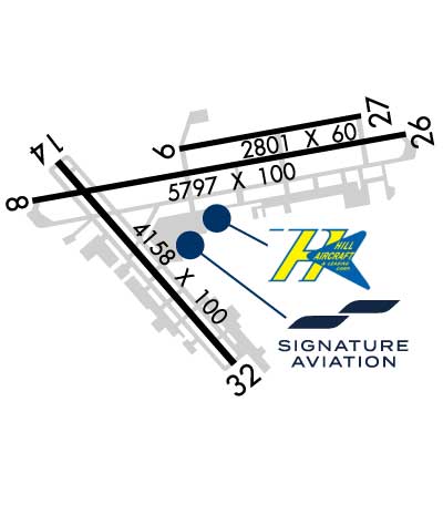
| Lat: N 3346.8 Long: W 08431.2 Elev: 841 Var: +05 Longest Runway: 5797 | ||
| Dept. ATIS: 120.17 Arr. ATIS: 120.17 Ground: 121.7 Tower: 118.45 | ||

| |||||||||||||||||||||||||||||||||||||||||||||||||||||||||||||||||||||
| |||||||||||||||||||||||||||||||||||||||||||||||||||||||||||||||||||||
| |||||||||||||||||||||||||||||||||||||||||||||||||||||||||||||||||||||
| |||||||||||||||||||||||||||||||||||||||||||||||||||||||||||||||||||||
| Rwy | Rwy | |||||||
| 5797x100 | 5797' | 109.10 - 084° | 5797x100 | 5797' | ||||
| Runway ID | Single Wheel | Double Wheel | Double Tandem Wheel | Dual Double Wheel |
| 08/26 | 105,000 | 121,000 | 198,000 | N/A |
| These numbers are Advisory and are not limits. The Airport Manager should have more accurate Weight Limits | ||||
 Airport Diagram might not be current. | |
| Facility Name: | FULTON COUNTY EXEC/CHARLIE BROWN FLD |
| City Name: | ATLANTA |
| County: | FULTON |
| State abbrev: | GA |
| State Name: | GEORGIA |
| Ownership: | PUBLICLY OWNED |
| Use: | OPEN TO THE PUBLIC |
| Owner's Name: | FULTON COUNTY |
| Address: | COUNTY COURTHOUSE, 141 PRYOR ST. |
| ATLANTA, GA 30303 | |
| Owner's Phone: | 404-699-4200 |
| Manager's Name: | GARY HUDSON |
| Address: | 3977 AVIATION CIRCLE |
| ATLANTA, GA 30336 | |
| Phone: | 404-613-4205 |
| FAA Region: | SOUTHERN |
| FAA Field Office: | ATL |

| Date | Sunrise | Sunset |
|---|---|---|
| 06/08/26 Monday | 6:27 | 20:47 |
| 06/09/26 Tuesday | 6:27 | 20:48 |
| 06/10/26 Wednesday | 6:27 | 20:48 |
| 06/11/26 Thursday | 6:27 | 20:49 |
| 06/12/26 Friday | 6:27 | 20:49 |
| 06/13/26 Saturday | 6:27 | 20:49 |
| 06/14/26 Sunday | 6:27 | 20:50 |
| 06/15/26 Monday | 6:27 | 20:50 |
| 06/16/26 Tuesday | 6:27 | 20:51 |
| 06/17/26 Wednesday | 6:27 | 20:51 |
| 06/18/26 Thursday | 6:27 | 20:51 |
| 06/19/26 Friday | 6:27 | 20:51 |
| 06/20/26 Saturday | 6:28 | 20:52 |
| 06/21/26 Sunday | 6:28 | 20:52 |
| Airport Attendance Schedule | CONTINUOUS |
| Airport Status | OPERATIONAL (This Status can change at any time - please check NOTAMS) |
| Airport Lighting Schedule | SS-SR |
| Airport Storage Available | Tie Downs, Hanger |
| Extra Services Available | Air Freight, Air Ambulance, Avionics, Cargo Handling, Charter, Flight Instruction, Aircraft Rental |
| Wind Indicator | YES - (unlit) |
| Control Tower | YES |
| CTAF Frequency | |
| Unicom Frequency | 122.950 |
| Rotating Beacon Color | WG |
| Segmented Circle | YES |
| Landing Fee | NO |
| Airport Inspected | STATE - performed by STATE AERONAUTICAL PERSONNEL |
| Inspection Date | 03/29/2024 |
| Type of Fuel Available | Grade 100LL, JET A; -10FUEL SVC HILL AVN, C404-691-3330. |
| Airframe Repair Service | MAJOR |
| Power Plant Repair Service | MAJOR |
| Latitude | N3346.8 |
| Longitude | W08431.2 (ESTIMATED) |
| Arpt Elevation | 841ft (SURVEYED) |
| Magnetic Variation | 05W |
| 6 miles W | of ATLANTA |
| Traffic Pattern Altitude | |
| Sectional Chart | ATLANTA |
| Operations (Reported) | Yearly | Avg. Daily |
|---|---|---|
| General Aviation Transient | 0 | 0 |
| General Aviation Local | 0 | 0 |
| Air Taxi | 0 | 0 |
| Commerical | 0 | 0 |
| Commuter | 0 | 0 |
| Military | 0 | 0 |
| Aircraft based on Field | |
|---|---|
| General Aviation Singles | 0 |
| General Aviation Multi | 0 |
| Jet Aircraft | 0 |
| General Aviation Helicopters | 0 |
| Military Aircraft | 0 |
| Gliders | 0 |
| Ultralights | 0 |
| FSS on field | NO |
| FSS tie-in | MACON |
| FSS Phone | 1-800-WX-BRIEF |
| Who issues Notams | FTY |
| Notam D service at airport | YES |
| ARTCC Name | ATLANTA |
| Airport Certification | |
| Aircraft Rescue & Firefighting Index | None |
| Airport of Entry | No |
| Custom Landing Rights | YES |
| Joint Civil/Military | No |
| Military Landing rights | YES |
| NATIONAL PLAN OF INTEGRATED AIRPORT SYSTEMS (NPIAS) |
| GRANT AGREEMENTS UNDER FAAP/ADAP/AIP |
| ASSURANCES PURSUANT TO TITLE VI, CIVIL RIGHTS ACT OF 1964 |
| FLOCKS OF BIRDS ON AND INVOF ARPT DURING DALGT HRS. |
| NOISE SENSITIVE AREA ALL QUADS; NO RUN UPS AUTH ON ANY RAMPS. |
| DEER AND OTHER WILDLIFE ON & INVOF ARPT. |
Airport Communications & Frequencies:
| |||||||||||||||||||||||||
| Runway: 08 | Runway: 26 | ||
| Mag heading: | 85° | Mag heading: | 265° |
| Rwy Slope: | .24% Up | Rwy Slope: | -.24% Down |
| Approach: | ILS | Approach: | |
| Pattern: | Left Traffic | Pattern: | Right Traffic |
| Markings: | PRECISION INSTRUMENT | Markings: | PRECISION INSTRUMENT |
| Marking Condition: | GOOD | Marking Condition: | GOOD |
| Arresting Dev: | Arresting Dev: | ||
| Lat & Long: | N3346.7 W08431.8 | Lat. & Long.: | N3346.9 W08430.7 |
| Elev: | 799.9 ft. MSL | Elev: | 814.1 ft. MSL |
| TCH: | TCH: | 50 ft. AGL | |
| Visual Glide Path: | Visual Glide Path: | 3.00 degrees | |
| Displaced Threshold: | No | Displaced Threshold: | No |
| Touchdown Zone: | YES | Touchdown Zone: | YES |
| Touchdown Elev.: | 807.5 feet | Touchdown Elev.: | 814.3 feet |
| Visual Glide Slope: | Visual Glide Slope: | 4-BOX VASI ON LEFT SIDE OF RUNWAY | |
| RVR Equipment: | RVR Equipment: | ||
| RVV Equipment: | NO | RVV Equipment: | NO |
| Approach Lights: | MALSR - 1,400 foot medium intensity approach lighting system with runway alignment indicator lights | Approach Lights: | |
| REIL: | NO | REIL: | YES |
| Centerline Lights: | NO | Centerline Lights: | NO |
| Touchdown lights: | NO | Touchdown lights: | NO |
| Runway Category: | Precision Instrument Runway | Runway Category: | Runway with a Non-precision Approach having visibility minimums greater than 3/4 mile |
| Declared Distances: | Declared Distances: | ||
| Obstructions: | TREES | Obstructions: | TREES |
| Marked: | NOT Marked/Lighted | Marked: | NOT Marked/Lighted |
| Clearance slope: | 17:1 | Clearance slope: | 19:1 |
| Obstruction height: | 75 feet AGL | Obstruction height: | 4 feet AGL |
| Dist. from runway: | 1475 feet | Dist. from runway: | 276 feet |
| Centerline offset: | 680 right of centerline | Centerline offset: | 509 feet left of centerline |
| Comments: | Comments: |
Thanks for using FltPlan.com
all rights reserved © 1999-2026 by Flight Plan LLC


