
| GODMAN AAF (PRIVATE) FORT KNOX KY |
| |
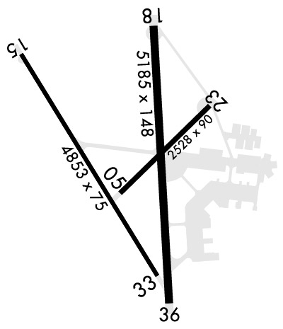
| Lat: N 3754.4 Long: W 08558.3 Elev: 754 Var: +03 Longest Runway: 5184 | ||
| Dept. ATIS: 109.6 Arr. ATIS: 109.6 Ground: 121.9 Tower: 133.35 | ||
| ||||||||||||||||||||||||||||||||||||||||||||
| ||||||||||||||||||||||||||||||||||||||||||||
| Rwy | Rwy | |||||||
| 4853x75 | 4853' | 4853x75 | 4853' | |||||
| 5184x150 | 5184' | 108.95 - 180° | 5184x150 | 5184' | ||||
| Runway ID | Single Wheel | Double Wheel | Double Tandem Wheel | Dual Double Wheel |
| 15/33 | N/A | N/A | N/A | N/A |
| 18/36 | N/A | N/A | N/A | N/A |
| These numbers are Advisory and are not limits. The Airport Manager should have more accurate Weight Limits | ||||
 Airport Diagram might not be current. | |
| Facility Name: | GODMAN AAF |
| City Name: | FORT KNOX |
| County: | HARDIN |
| State abbrev: | KY |
| State Name: | KENTUCKY |
| Ownership: | ARMY OWNED |
| Use: | PRIVATE |
| Owner's Name: | US ARMY ATCA-ASO |
| Address: | CAMERON STA |
| ALEXANDRIA, VA 22314 | |
| Owner's Phone: | |
| Manager's Name: | RICKEY WEBB |
| Address: | |
| Phone: | 502-624-5737 |
| FAA Region: | SOUTHERN |
| FAA Field Office: | MEM |
| Date | Sunrise | Sunset |
|---|---|---|
| 09/24/21 Friday | 7:33 | 19:38 |
| 09/25/21 Saturday | 7:34 | 19:37 |
| 09/26/21 Sunday | 7:35 | 19:35 |
| 09/27/21 Monday | 7:36 | 19:33 |
| 09/28/21 Tuesday | 7:37 | 19:32 |
| 09/29/21 Wednesday | 7:38 | 19:30 |
| 09/30/21 Thursday | 7:38 | 19:29 |
| 10/01/21 Friday | 7:39 | 19:27 |
| 10/02/21 Saturday | 7:40 | 19:26 |
| 10/03/21 Sunday | 7:41 | 19:24 |
| 10/04/21 Monday | 7:42 | 19:23 |
| 10/05/21 Tuesday | 7:43 | 19:21 |
| 10/06/21 Wednesday | 7:44 | 19:20 |
| 10/07/21 Thursday | 7:45 | 19:18 |
| Airport Attendance Schedule | CONTINUOUS; SEE FLIP AP/1 SUPPLEMENTARY ARPT |
| Airport Status | OPERATIONAL (This Status can change at any time - please check NOTAMS) |
| Airport Lighting Schedule | ACTVT SSALR RWY 18; ODALS RWY 36; REIL RWY 18; PAPI RWY 18 & 36; HIRL 18/36 - CTAF. 0400-1200Z++. |
| Airport Storage Available | NONE |
| Extra Services Available | NONE |
| Wind Indicator | NONE |
| Control Tower | YES |
| CTAF Frequency | 133.350 |
| Unicom Frequency | |
| Rotating Beacon Color | SPLIT-CLEAR-GREEN (LIGHTED MILITARY AIRPORT); ROT BCN LCTD ON ATC TWR. |
| Segmented Circle | NO |
| Landing Fee |
| Airport Inspected | No Inspection Data Available performed by the OWNER |
| Inspection Date | Unknown |
| Type of Fuel Available | ++; -A+MIL: AVBL 1200-0400Z++ MON-SAT; CLSD SUN & HOL. WHEN AFLD OPS & TWR CLSD - 502-624-7763. |
| Airframe Repair Service | None |
| Power Plant Repair Service | None |
| Latitude | N3754.4 |
| Longitude | W08558.3 (ESTIMATED) |
| Arpt Elevation | 754ft (SURVEYED) |
| Magnetic Variation | 03W |
| 1 miles W | of FORT KNOX |
| Traffic Pattern Altitude | TFC PAT W OF AFLD. ROTARY WING 1500 FT; FIXED WING 2300 FT; OVERHEAD 2300 FT. |
| Sectional Chart | ST LOUIS |
| Operations (Reported) | Yearly | Avg. Daily |
|---|---|---|
| General Aviation Transient | 0 | 0 |
| General Aviation Local | 0 | 0 |
| Air Taxi | 0 | 0 |
| Commerical | 0 | 0 |
| Commuter | 0 | 0 |
| Military | 0 | 0 |
| Aircraft based on Field | |
|---|---|
| General Aviation Singles | 0 |
| General Aviation Multi | 0 |
| Jet Aircraft | 0 |
| General Aviation Helicopters | 0 |
| Military Aircraft | 0 |
| Gliders | 0 |
| Ultralights | 0 |
| FSS on field | NO |
| FSS tie-in | LOUISVILLE |
| FSS Phone | 1-800-WX-BRIEF |
| Who issues Notams | FTK |
| Notam D service at airport | YES |
| ARTCC Name | INDIANAPOLIS |
| Airport Certification | |
| Aircraft Rescue & Firefighting Index | None |
| Airport of Entry | No |
| Custom Landing Rights | No |
| Joint Civil/Military | No |
| Military Landing rights | No |
| DEER & COYOTE INVOF ARPT SPCLY 1 HR PRIOR SR & SS. |
| MISC: ALL WX FCST, PMSV BRIEFINGS & SUPPORT 1100-0400++ MON-FRI; 1100-0300++ SAT & SUN; CLSD HOL; OTHERWISE CTC SCOTT OWS DSN 576-9755/9702, C618-256-9755/9702, HTTPS://15OWS.US.AF.MIL. WX OBS AUTO & AUGMENTED AS RQR. |
| TSNT ACFT PRKG ON GREEN RAMP UNLESS ALTN PRKG COORD. C-130 & LARGER PARK ON CONC PAD BTW TWY A & B. |
| MISC: RANGE INFO - 38.90; 136.075. |
| MISC: IR LGT INSTL APCH END RWY 15 ASSAULT STRIP. |
| SEE FLIP AP/1 & FT KNOX REG 95-1 SUPPLEMENTARY ARPT INFO. |
| RSTD: OFFL BUS ONLY; PPR DSN 464-5536, C502-624-5536; VIP CTC OPS 20 MIN PRIOR TO LDG. |
| COMM: AIR TO AIR UHF 237.5 WI FORT KNOX ASP. |
| COMMUNICATIONS: PTD OPS 1230-2100Z++ MON-FRI; CLSD HOL. CTAF - 133.35; PTD - 126.2, 234.4; ATIS - 109.6; LOUSIVILLE APP/DEP 132.075, 327.0. |
| AIRFIELD OPS 126.2, 234.4; 1230-2100Z++ MON-FRI; CLSD HOL. |
| NON-MOVEMENT AREA BLUE, YELLOW, GOLD & TWY D FM BLUE RAMP TO POINT NORTH. VEHICLE ACCESS TO FLIGHTLINE UNAVBL WHEN AIRFIELD OPS CLSD. |
| TRANSIT ALERT SVC NOT AVBL. |
| NO SHOULDERS RWY 18/36, 15/33, TWY B, C, & D. TWY F UNLGT. |
| MISC: RWY 33 & 36 CLEAR ZONES NSTD. |
| FICON UNAVBL WHEN AIRFIELD OPS CLSD. |
| WHEN TWR & AIRFIELD OPS CLSD USE 126.2 FOR IFR/SVFR CLNCS, RELEASES, & ARR. IF UNBL CTC LOUISVILLE APP/DEP C502-375-7499. |
| CAUTION: RR CROSS NW - SE; 625 FT FM AER 18 CNTRLN; ARR RWY 18 OR DEP RWY 36 NA WHEN RAIL CARS WI RWY CLEAR ZONE. FENCE 565 FT FM AER 18. RSTD AREA 1 NM E OF ARPT. OVERFLIGHT OF GOLD DEPOSITORY 1 NM S OF RWY 36 NA. EXTV UAS OPS IN CLASS D & R3704A/B. R/W AIRCREWS PLANNING OPS WI R3704A MUST RCV RANGE BRIEFING PRIOR TO OPS. |
Airport Communications & Frequencies:
| |||||||||||||||||||||||||||||
| Runway: 15 | Runway: 33 | ||
| Mag heading: | N/A | Mag heading: | N/A |
| Rwy Slope: | -.51% Down | Rwy Slope: | .51% Up |
| Approach: | Approach: | ||
| Pattern: | Left Traffic | Pattern: | Left Traffic |
| Markings: | NONPRECISION INSTRUMENT | Markings: | NONPRECISION INSTRUMENT |
| Marking Condition: | GOOD | Marking Condition: | GOOD |
| Arresting Dev: | Arresting Dev: | ||
| Lat & Long: | N3754.8 W08558.7 | Lat. & Long.: | N3754.1 W08558.2 |
| Elev: | 754.3 ft. MSL | Elev: | 729.7 ft. MSL |
| TCH: | TCH: | ||
| Visual Glide Path: | Visual Glide Path: | ||
| Displaced Threshold: | No | Displaced Threshold: | No |
| Touchdown Zone: | YES | Touchdown Zone: | YES |
| Touchdown Elev.: | 754.3 feet | Touchdown Elev.: | 736.8 feet |
| Visual Glide Slope: | Visual Glide Slope: | ||
| RVR Equipment: | RVR Equipment: | ||
| RVV Equipment: | NO | RVV Equipment: | NO |
| Approach Lights: | Approach Lights: | ||
| REIL: | YES | REIL: | YES |
| Centerline Lights: | NO | Centerline Lights: | NO |
| Touchdown lights: | NO | Touchdown lights: | NO |
| Runway Category: | Runway Category: | ||
| Declared Distances: | Declared Distances: |
| Runway: 18 | Runway: 36 | ||
| Mag heading: | N/A | Mag heading: | N/A |
| Rwy Slope: | -.50% Down | Rwy Slope: | .50% Up |
| Approach: | ILS/DME | Approach: | |
| Pattern: | Left Traffic | Pattern: | Left Traffic |
| Markings: | NONPRECISION INSTRUMENT | Markings: | NONPRECISION INSTRUMENT |
| Marking Condition: | GOOD | Marking Condition: | GOOD |
| Arresting Dev: | Arresting Dev: | ||
| Lat & Long: | N3754.9 W08558.2 | Lat. & Long.: | N3754.0 W08558.2 |
| Elev: | 753.6 ft. MSL | Elev: | 727.6 ft. MSL |
| TCH: | 50 ft. AGL | TCH: | 60 ft. AGL |
| Visual Glide Path: | 3.00 degrees | Visual Glide Path: | 3.00 degrees |
| Displaced Threshold: | No | Displaced Threshold: | No |
| Touchdown Zone: | YES | Touchdown Zone: | YES |
| Touchdown Elev.: | 753.6 feet | Touchdown Elev.: | 740.4 feet |
| Visual Glide Slope: | 4-Light PAPI on LEFT side of Runway | Visual Glide Slope: | 4-Light PAPI on LEFT side of Runway |
| RVR Equipment: | RVR Equipment: | ||
| RVV Equipment: | NO | RVV Equipment: | NO |
| Approach Lights: | SSALR - simplified short approach lighting system with runway alignment indicator lights | Approach Lights: | ODALS - omnidirectional approach lighting system |
| REIL: | YES | REIL: | NO |
| Centerline Lights: | NO | Centerline Lights: | NO |
| Touchdown lights: | NO | Touchdown lights: | NO |
| Runway Category: | Runway Category: | ||
| Declared Distances: | Declared Distances: |
Thanks for using FltPlan.com
all rights reserved © 1999-2021 by Flight Plan LLC