
| FORT STOCKTON-PECOS COUNTY FORT STOCKTON TX |
| |
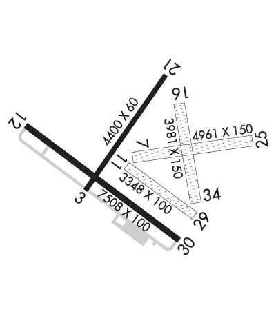
| Lat: N 3054.9 Long: W 10254.8 Elev: 3011 Var: -09 Longest Runway: 7508 | ||
| AWOS: 118.52 CTAF: 122.8 | ||
| ||||||
| ||||||
|
| Rwy | Rwy | |||||||
| 4400x60 | 4400' | 4400x60 | 4400' | |||||
| 4961x150 | 4961' | 4961x150 | 4961' | |||||
| 3348x100 | 3348' | 3348x100 | 3348' | |||||
| 7508x100 | 7508' | 7508x100 | 7508' | |||||
| 3981x150 | 3981' | 3981x150 | 3981' | |||||
| Runway ID | Single Wheel | Double Wheel | Double Tandem Wheel | Dual Double Wheel |
| 03/21 | N/A | N/A | N/A | N/A |
| 07/25 | N/A | N/A | N/A | N/A |
| 11/29 | N/A | N/A | N/A | N/A |
| 12/30 | 24,000 | N/A | N/A | N/A |
| 16/34 | N/A | N/A | N/A | N/A |
| These numbers are Advisory and are not limits. The Airport Manager should have more accurate Weight Limits | ||||
 Airport Diagram might not be current. | |
| Facility Name: | FORT STOCKTON-PECOS COUNTY |
| City Name: | FORT STOCKTON |
| County: | PECOS |
| State abbrev: | TX |
| State Name: | TEXAS |
| Ownership: | PUBLICLY OWNED |
| Use: | OPEN TO THE PUBLIC |
| Owner's Name: | PECOS COUNTY |
| Address: | PECOS COUNTY COURTHOUSE, 103 W CALLAGHAN |
| FORT STOCKTON, TX 79735 | |
| Owner's Phone: | 432-336-2792 |
| Manager's Name: | TOM CHAPMAN; COUNTY COMMISSIONER. |
| Address: | PO BOX 1624 |
| FORT STOCKTON, TX 79735 | |
| Phone: | 432-336-6261 |
| FAA Region: | SOUTHWEST |
| FAA Field Office: | TEX |
| Date | Sunrise | Sunset |
|---|---|---|
| 09/24/21 Friday | 7:41 | 19:46 |
| 09/25/21 Saturday | 7:42 | 19:45 |
| 09/26/21 Sunday | 7:42 | 19:43 |
| 09/27/21 Monday | 7:43 | 19:42 |
| 09/28/21 Tuesday | 7:43 | 19:41 |
| 09/29/21 Wednesday | 7:44 | 19:40 |
| 09/30/21 Thursday | 7:45 | 19:38 |
| 10/01/21 Friday | 7:45 | 19:37 |
| 10/02/21 Saturday | 7:46 | 19:36 |
| 10/03/21 Sunday | 7:46 | 19:35 |
| 10/04/21 Monday | 7:47 | 19:33 |
| 10/05/21 Tuesday | 7:48 | 19:32 |
| 10/06/21 Wednesday | 7:48 | 19:31 |
| 10/07/21 Thursday | 7:49 | 19:30 |
| Airport Attendance Schedule | 7 Days A Week 0800-1700 |
| Airport Status | OPERATIONAL (This Status can change at any time - please check NOTAMS) |
| Airport Lighting Schedule | MIRL RWY 03/21 & 12/30 PRESET LOW INTST; TO INCR INTST ACTVT - CTAF. PAPI RWY 12 & 30 OPR CONSLY. |
| Airport Storage Available | Tie Downs, Hanger |
| Extra Services Available | Crop Dusting |
| Wind Indicator | YES - (lighted) |
| Control Tower | NO |
| CTAF Frequency | 122.800 |
| Unicom Frequency | 122.800 |
| Rotating Beacon Color | CLEAR-GREEN (Light Land Airport) |
| Segmented Circle | YES |
| Landing Fee | NO |
| Airport Inspected | STATE - performed by PRIVATE CONTRACT PERSONNEL |
| Inspection Date | 05/17/2021 |
| Type of Fuel Available | Grade 100LL, JET A; -10FOR FUEL & SVCS AFT HRS CALL 432-336-9900 OR UNICOM. 24 HR SELF SERVE AVBL WITH MAJOR CREDIT CARD. |
| Airframe Repair Service | None |
| Power Plant Repair Service | None |
| Latitude | N3054.9 |
| Longitude | W10254.8 (ESTIMATED) |
| Arpt Elevation | 3011ft (SURVEYED) |
| Magnetic Variation | 09E |
| 2 miles NW | of FORT STOCKTON |
| Traffic Pattern Altitude | |
| Sectional Chart | SAN ANTONIO |
| Operations (Reported) | Yearly | Avg. Daily |
|---|---|---|
| General Aviation Transient | 1500 | 4 |
| General Aviation Local | 3000 | 8 |
| Air Taxi | 0 | 0 |
| Commerical | 0 | 0 |
| Commuter | 0 | 0 |
| Military | 20 | 0 |
| Aircraft based on Field | |
|---|---|
| General Aviation Singles | 15 |
| General Aviation Multi | 1 |
| Jet Aircraft | 0 |
| General Aviation Helicopters | 1 |
| Military Aircraft | 0 |
| Gliders | 2 |
| Ultralights | 0 |
| FSS on field | NO |
| FSS tie-in | SAN ANGELO |
| FSS Phone | 1-800-WX-BRIEF |
| Who issues Notams | FST |
| Notam D service at airport | YES |
| ARTCC Name | ALBUQUERQUE |
| Airport Certification | |
| Aircraft Rescue & Firefighting Index | None |
| Airport of Entry | No |
| Custom Landing Rights | No |
| Joint Civil/Military | No |
| Military Landing rights | YES |
| NATIONAL PLAN OF INTEGRATED AIRPORT SYSTEMS (NPIAS) |
| SURPLUS PROPERTY AGREEMENT UNDER REGULATION 16-WAA |
| GRANT AGREEMENT HAS EXPIRED; HOWEVER, AGREEMENT REMAINS IN EFFECT FOR THIS FACILITY AS LONG AS IT IS PUBLIC USE. |
| 3210 FT TOWER 2 MILES NE. |
| FOR CD IF UNA TO CTC ON FSS FREQ, CTC ALBUQUERQUE ARTCC AT 505-856-4561. |
| TURF RWY 7/25, 11/29,16/34 ROUGH. RWY ENDS 16 & 25 NOT INSPECTED DUE TO FLD CONDS. |
| RWY 07/2 5 RWY NOT MNTND; HAS TALL WEEDS, GRASS AND THORNS. |
| RWY 11/2 9 RWY NOT MNTND; HAS TALL WEEDS, GRASS AND THORNS. |
| RWY 16/3 4 RWY NOT MNTND; HAS TALL WEEDS, GRASS AND THORNS. |
Airport Communications & Frequencies:
| |||||||||
| Runway: 03 | Runway: 21 | ||
| Mag heading: | 28° | Mag heading: | 208° |
| Rwy Slope: | -1.14% Down | Rwy Slope: | 1.14% Up |
| Approach: | Approach: | ||
| Pattern: | Left Traffic | Pattern: | Left Traffic |
| Markings: | BASIC | Markings: | BASIC |
| Marking Condition: | FAIR | Marking Condition: | FAIR |
| Arresting Dev: | Arresting Dev: | ||
| Lat & Long: | N3054.8 W10255.1 | Lat. & Long.: | N3055.4 W10254.6 |
| Elev: | 3006.7 ft. MSL | Elev: | 2956.7 ft. MSL |
| TCH: | TCH: | ||
| Visual Glide Path: | Visual Glide Path: | ||
| Displaced Threshold: | No | Displaced Threshold: | No |
| Touchdown Zone: | YES | Touchdown Zone: | YES |
| Touchdown Elev.: | 3006.7 feet | Touchdown Elev.: | 2988.8 feet |
| Visual Glide Slope: | Visual Glide Slope: | ||
| RVR Equipment: | RVR Equipment: | ||
| RVV Equipment: | NO | RVV Equipment: | NO |
| Approach Lights: | Approach Lights: | ||
| REIL: | NO | REIL: | NO |
| Centerline Lights: | NO | Centerline Lights: | NO |
| Touchdown lights: | NO | Touchdown lights: | NO |
| Runway Category: | Runway with a Visual Approach | Runway Category: | Runway with a Visual Approach |
| Declared Distances: | Declared Distances: | ||
| Obstructions: | PLINE | Obstructions: | |
| Marked: | NOT Marked/Lighted | Marked: | |
| Clearance slope: | 26:1 | Clearance slope: | 50:1 |
| Obstruction height: | 110 feet AGL | Obstruction height: | |
| Dist. from runway: | 3100 feet | Dist. from runway: | |
| Centerline offset: | Centerline offset: | ||
| Comments: | Comments: |
| Runway: 07 | Runway: 25 | ||
| Mag heading: | 73° | Mag heading: | 253° |
| Rwy Slope: | -.57% Down | Rwy Slope: | .57% Up |
| Approach: | Approach: | ||
| Pattern: | Left Traffic | Pattern: | Left Traffic |
| Markings: | NONE | Markings: | NONE |
| Marking Condition: | FAIR | Marking Condition: | FAIR |
| Arresting Dev: | Arresting Dev: | ||
| Lat & Long: | N3054.9 W10255.0 | Lat. & Long.: | N3055.0 W10254.0 |
| Elev: | 2994.1 ft. MSL | Elev: | 2965.6 ft. MSL |
| TCH: | TCH: | ||
| Visual Glide Path: | Visual Glide Path: | ||
| Displaced Threshold: | No | Displaced Threshold: | No |
| Touchdown Zone: | YES | Touchdown Zone: | YES |
| Touchdown Elev.: | 2994.1 feet | Touchdown Elev.: | 2982.8 feet |
| Visual Glide Slope: | Visual Glide Slope: | ||
| RVR Equipment: | RVR Equipment: | ||
| RVV Equipment: | NO | RVV Equipment: | NO |
| Approach Lights: | Approach Lights: | ||
| REIL: | NO | REIL: | NO |
| Centerline Lights: | NO | Centerline Lights: | NO |
| Touchdown lights: | NO | Touchdown lights: | NO |
| Runway Category: | Runway with a Visual Approach | Runway Category: | Runway with a Visual Approach |
| Declared Distances: | Declared Distances: | ||
| Obstructions: | Obstructions: | TREES | |
| Marked: | Marked: | NOT Marked/Lighted | |
| Clearance slope: | 50:1 | Clearance slope: | 20:1 |
| Obstruction height: | Obstruction height: | 9 feet AGL | |
| Dist. from runway: | Dist. from runway: | 186 feet | |
| Centerline offset: | Centerline offset: | 23 feet left of centerline | |
| Comments: | Comments: |
| Runway: 11 | Runway: 29 | ||
| Mag heading: | 117° | Mag heading: | 297° |
| Rwy Slope: | .30% Up | Rwy Slope: | -.30% Down |
| Approach: | Approach: | ||
| Pattern: | Left Traffic | Pattern: | Left Traffic |
| Markings: | NONE | Markings: | NONE |
| Marking Condition: | POOR; THR NOT MKD. | Marking Condition: | POOR; THR NOT MKD. |
| Arresting Dev: | Arresting Dev: | ||
| Lat & Long: | N3054.9 W10255.0 | Lat. & Long.: | N3054.6 W10254.5 |
| Elev: | 2995.5 ft. MSL | Elev: | 3005.4 ft. MSL |
| TCH: | TCH: | ||
| Visual Glide Path: | Visual Glide Path: | ||
| Displaced Threshold: | No | Displaced Threshold: | No |
| Touchdown Zone: | YES | Touchdown Zone: | YES |
| Touchdown Elev.: | 3004.4 feet | Touchdown Elev.: | 3005.4 feet |
| Visual Glide Slope: | Visual Glide Slope: | ||
| RVR Equipment: | RVR Equipment: | ||
| RVV Equipment: | NO | RVV Equipment: | NO |
| Approach Lights: | Approach Lights: | ||
| REIL: | NO | REIL: | NO |
| Centerline Lights: | NO | Centerline Lights: | NO |
| Touchdown lights: | NO | Touchdown lights: | NO |
| Runway Category: | Runway with a Visual Approach | Runway Category: | Runway with a Visual Approach |
| Declared Distances: | Declared Distances: | ||
| Obstructions: | Obstructions: | ROAD | |
| Marked: | Marked: | NOT Marked/Lighted | |
| Clearance slope: | 50:1 | Clearance slope: | 6:1 |
| Obstruction height: | Obstruction height: | 10 feet AGL | |
| Dist. from runway: | Dist. from runway: | 65 feet | |
| Centerline offset: | Centerline offset: | ||
| Comments: | Comments: |
| Runway: 12 | Runway: 30 | ||
| Mag heading: | 118° | Mag heading: | 298° |
| Rwy Slope: | .34% Up | Rwy Slope: | -.34% Down |
| Approach: | Approach: | ||
| Pattern: | Left Traffic | Pattern: | Left Traffic |
| Markings: | NONPRECISION INSTRUMENT | Markings: | NONPRECISION INSTRUMENT |
| Marking Condition: | GOOD | Marking Condition: | GOOD |
| Arresting Dev: | Arresting Dev: | ||
| Lat & Long: | N3055.2 W10255.6 | Lat. & Long.: | N3054.5 W10254.5 |
| Elev: | 2985.2 ft. MSL | Elev: | 3010.4 ft. MSL |
| TCH: | 45 ft. AGL | TCH: | 45 ft. AGL |
| Visual Glide Path: | 3.00 degrees | Visual Glide Path: | 3.00 degrees |
| Displaced Threshold: | No | Displaced Threshold: | No |
| Touchdown Zone: | YES | Touchdown Zone: | YES |
| Touchdown Elev.: | 3002.0 feet | Touchdown Elev.: | 3011.0 feet |
| Visual Glide Slope: | 4-Light PAPI on LEFT side of Runway; UNUSBL BYD 8 DEG RIGHT OF RCL. | Visual Glide Slope: | 4-Light PAPI on LEFT side of Runway; UNUSBL BYD 8 DEG RIGHT OF RCL. |
| RVR Equipment: | RVR Equipment: | ||
| RVV Equipment: | NO | RVV Equipment: | NO |
| Approach Lights: | Approach Lights: | ||
| REIL: | NO | REIL: | NO |
| Centerline Lights: | NO | Centerline Lights: | NO |
| Touchdown lights: | NO | Touchdown lights: | NO |
| Runway Category: | Runway with a Non-precision Approach having visibility minimums greater than 3/4 mile | Runway Category: | Runway with a Non-precision Approach having visibility minimums greater than 3/4 mile |
| Declared Distances: | Declared Distances: | ||
| Obstructions: | TREE | Obstructions: | ROAD |
| Marked: | NOT Marked/Lighted | Marked: | NOT Marked/Lighted |
| Clearance slope: | 15:1 | Clearance slope: | |
| Obstruction height: | 20 feet AGL | Obstruction height: | 10 feet AGL |
| Dist. from runway: | 500 feet | Dist. from runway: | 200 feet |
| Centerline offset: | 165 left of centerline | Centerline offset: | |
| Comments: | 5 FT FENCE, 0-199 FT DSTC, 145 FT L. | Comments: | GRAVEL ROAD AT 190 FT ACRS APCH. |
| Runway: 16 | Runway: 34 | ||
| Mag heading: | 162° | Mag heading: | 342° |
| Rwy Slope: | .99% Up | Rwy Slope: | -.99% Down |
| Approach: | Approach: | ||
| Pattern: | Left Traffic | Pattern: | Left Traffic |
| Markings: | NONE | Markings: | NONE |
| Marking Condition: | FAIR | Marking Condition: | FAIR |
| Arresting Dev: | Arresting Dev: | ||
| Lat & Long: | N3055.2 W10254.6 | Lat. & Long.: | N3054.6 W10254.5 |
| Elev: | 2964.2 ft. MSL | Elev: | 3003.7 ft. MSL |
| TCH: | TCH: | ||
| Visual Glide Path: | Visual Glide Path: | ||
| Displaced Threshold: | No | Displaced Threshold: | No |
| Touchdown Zone: | YES | Touchdown Zone: | YES |
| Touchdown Elev.: | 2994.0 feet | Touchdown Elev.: | 3003.7 feet |
| Visual Glide Slope: | Visual Glide Slope: | ||
| RVR Equipment: | RVR Equipment: | ||
| RVV Equipment: | NO | RVV Equipment: | NO |
| Approach Lights: | Approach Lights: | ||
| REIL: | NO | REIL: | NO |
| Centerline Lights: | NO | Centerline Lights: | NO |
| Touchdown lights: | NO | Touchdown lights: | NO |
| Runway Category: | Runway with a Visual Approach | Runway Category: | Runway with a Visual Approach |
| Declared Distances: | Declared Distances: | ||
| Obstructions: | BRUSH; 10 FT TREES AND BRUSH AT THR ACRS APCH. | Obstructions: | TREE |
| Marked: | NOT Marked/Lighted | Marked: | NOT Marked/Lighted |
| Clearance slope: | Clearance slope: | 22:1 | |
| Obstruction height: | 10 feet AGL | Obstruction height: | 58 feet AGL |
| Dist. from runway: | 0 feet | Dist. from runway: | 1317 feet |
| Centerline offset: | Centerline offset: | 82 feet left of centerline | |
| Comments: | Comments: |
Thanks for using FltPlan.com
all rights reserved © 1999-2021 by Flight Plan LLC
