
| HENRY POST AAF (PRIVATE) FORT SILL OK |
| |
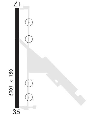
| Lat: N 3439.0 Long: W 09824.1 Elev: 1188 Var: -04 Longest Runway: 5002 | ||
| Clr Del: 121.7 Dept. ATIS: 135.42 Arr. ATIS: 135.42 Ground: 121.7 Tower: 124.95 | ||
| ||||||||||||||||||||||||||||||||
| ||||||||||||||||||||||||||||||||
| Rwy | Rwy | |||||||
| 5002x150 | 5002' | 5002x150 | 5002' | |||||
| Runway ID | Single Wheel | Double Wheel | Double Tandem Wheel | Dual Double Wheel |
| 18/36 | N/A | N/A | N/A | N/A |
| These numbers are Advisory and are not limits. The Airport Manager should have more accurate Weight Limits | ||||
 Airport Diagram might not be current. | |
| Facility Name: | HENRY POST AAF (FORT SILL) |
| City Name: | FORT SILL |
| County: | COMANCHE |
| State abbrev: | OK |
| State Name: | OKLAHOMA |
| Ownership: | ARMY OWNED |
| Use: | PRIVATE |
| Owner's Name: | US ARMY AERONAUTICAL SVCS AGENCY |
| Address: | |
| FT BELVOIR, VA 22060 | |
| Owner's Phone: | |
| Manager's Name: | |
| Address: | |
| Phone: | 580-442-4643; 580-442-6014. |
| FAA Region: | SOUTHWEST |
| FAA Field Office: | AOK |
| Date | Sunrise | Sunset |
|---|---|---|
| 09/24/21 Friday | 7:23 | 19:28 |
| 09/25/21 Saturday | 7:24 | 19:26 |
| 09/26/21 Sunday | 7:24 | 19:25 |
| 09/27/21 Monday | 7:25 | 19:24 |
| 09/28/21 Tuesday | 7:26 | 19:22 |
| 09/29/21 Wednesday | 7:27 | 19:21 |
| 09/30/21 Thursday | 7:27 | 19:19 |
| 10/01/21 Friday | 7:28 | 19:18 |
| 10/02/21 Saturday | 7:29 | 19:17 |
| 10/03/21 Sunday | 7:30 | 19:15 |
| 10/04/21 Monday | 7:30 | 19:14 |
| 10/05/21 Tuesday | 7:31 | 19:12 |
| 10/06/21 Wednesday | 7:32 | 19:11 |
| 10/07/21 Thursday | 7:33 | 19:10 |
| Airport Attendance Schedule | |
| Airport Status | OPERATIONAL (This Status can change at any time - please check NOTAMS) |
| Airport Lighting Schedule | RDO REQ |
| Airport Storage Available | NONE |
| Extra Services Available | NONE |
| Wind Indicator | NONE |
| Control Tower | YES |
| CTAF Frequency | 124.950 |
| Unicom Frequency | |
| Rotating Beacon Color | SPLIT-CLEAR-GREEN (LIGHTED MILITARY AIRPORT) |
| Segmented Circle | NO |
| Landing Fee |
| Airport Inspected | No Inspection Data Available performed by the OWNER |
| Inspection Date | Unknown |
| Type of Fuel Available | None |
| Airframe Repair Service | None |
| Power Plant Repair Service | None |
| Latitude | N3439.0 |
| Longitude | W09824.1 (ESTIMATED) |
| Arpt Elevation | 1188ft (SURVEYED) |
| Magnetic Variation | 04E |
| 1 miles SE | of FORT SILL |
| Traffic Pattern Altitude | R/W 1900 FT MSL, F/W 2700 FT MSL. |
| Sectional Chart | DALLAS-FT WORTH |
| Operations (Reported) | Yearly | Avg. Daily |
|---|---|---|
| General Aviation Transient | 0 | 0 |
| General Aviation Local | 0 | 0 |
| Air Taxi | 0 | 0 |
| Commerical | 0 | 0 |
| Commuter | 0 | 0 |
| Military | 0 | 0 |
| Aircraft based on Field | |
|---|---|
| General Aviation Singles | 0 |
| General Aviation Multi | 0 |
| Jet Aircraft | 0 |
| General Aviation Helicopters | 0 |
| Military Aircraft | 0 |
| Gliders | 0 |
| Ultralights | 0 |
| FSS on field | NO |
| FSS tie-in | MC ALESTER |
| FSS Phone | 1-800-WX-BRIEF |
| Who issues Notams | FSI |
| Notam D service at airport | YES |
| ARTCC Name | FORT WORTH |
| Airport Certification | |
| Aircraft Rescue & Firefighting Index | None |
| Airport of Entry | No |
| Custom Landing Rights | No |
| Joint Civil/Military | No |
| Military Landing rights | No |
| MISC: WX FCST AVBL 1200-0400Z++ MON-FRI, EXC HOL. REMOTE BRIEFING SVC AVBL 26 OWS BARKSDALE AFB DSN 331-2651, C318-529-2651, HTTPS://26OWS.US.AF.MIL/. |
| AFLD MGMT OPR 1230-2100Z ++ MON-FRI EXC HOL. OTHER SVCS AVAILABLE AS PUBLISHED/NOTAM. DSN 639-4643/2023, C580-442-4643/2023, WX DSN 639-4000/4887, C580-442-4000/4887. |
| MISC: WX OBSN AUTOMATED 24/7. WX OBSN AUGMENTED (AS RQR) DUR HRS WX FCST AVBL. WX OBSN VIS LTD TO 0.25 SM N AND NE WHEN SFC WX OBSN VIS SENSOR AUGMENTED. |
| SERVICE - LGT: ACTVT PAPI RWY 18 ON 124.95. APCH, PAPI AND RWY 36 LGT OPR O/R TO TWR OR APP. |
| SVC: REFUEL SERVICES AVBL MON-FRI, 1330-2130Z++ EXCLUDING HOLS WITH 24 HR PPR. OTHER TIMES RQR 48 HR PPR. TSNT AIRCREW MUST REMAIN WITH ACFT TO PRVD TECHNICAL DIRECT/ASSISTANCE FOR FUEL SERVICES. CTC AIRFIELD MANAGEMENT DSN 639-2023/4643 COMMERCIAL 580-442-2023/4643. |
| TWY A AND TWY C PCN GWT RSTD, C-130 AND LRGR MUST USE TWY B FOR RWY ENTRY & EXIT. |
| 24 HR PPR ALL TRANS ACFT. |
| RWY 18-36 NSTD SAFETY ARE BYD EACH END DUE TO TERRAIN GRADE, NO PAVED OVERRUNS. |
| AFLD COND UNMTO WHEN AFLD MGMT CLSD. |
| MISC: WIND CONES LCTED 353 FT FM RWY EDGE. RWY EDGE LTS LCTED 26 FT FROM RWY EDGE LINE. |
| POTENTIAL FOR BIRD ACT NEAR POND NW OF AER RWY 18. |
| HENRY POST AIRFIELD IS LOCATED WI RESTRICTED SPECIAL USE AIRSPACE R5601. CTC FORT SILL APPROACH FOR ACCESS. |
| AIRFIELD LIGHTING CONTROLLED BY FORT SILL ARAC. |
| TOWER OPRS HRS BY NOTAM ONLY. |
| FORT SILL ARAC OPRS 24/7/365. |
| TRAN ALERT: NO TRAN MAINT, LTD SVC. TRAN AIRCREW MUST REMAIN WITH ACFT TO PROVIDE TECHNICAL DRCT/ASSIST IN SVCG. |
Airport Communications & Frequencies:
| |||||||||||||||||||||||||||||||||||||||
| Runway: 18 | Runway: 36 | ||
| Mag heading: | N/A | Mag heading: | N/A |
| Rwy Slope: | -.38% Down | Rwy Slope: | .38% Up |
| Approach: | Approach: | ||
| Pattern: | Left Traffic | Pattern: | Left Traffic |
| Markings: | PRECISION INSTRUMENT | Markings: | PRECISION INSTRUMENT |
| Marking Condition: | GOOD | Marking Condition: | GOOD |
| Arresting Dev: | Arresting Dev: | ||
| Lat & Long: | N3439.4 W09824.1 | Lat. & Long.: | N3438.6 W09824.1 |
| Elev: | 1185.4 ft. MSL | Elev: | 1166.2 ft. MSL |
| TCH: | 44 ft. AGL | TCH: | 61 ft. AGL |
| Visual Glide Path: | 3.00 degrees | Visual Glide Path: | 3.00 degrees |
| Displaced Threshold: | No | Displaced Threshold: | No |
| Touchdown Zone: | YES | Touchdown Zone: | YES |
| Touchdown Elev.: | 1188.3 feet | Touchdown Elev.: | 1187.1 feet |
| Visual Glide Slope: | 4-Light PAPI on LEFT side of Runway | Visual Glide Slope: | 4-Light PAPI on LEFT side of Runway |
| RVR Equipment: | RVR Equipment: | ||
| RVV Equipment: | NO | RVV Equipment: | NO |
| Approach Lights: | Approach Lights: | SALS | |
| REIL: | YES | REIL: | NO |
| Centerline Lights: | NO | Centerline Lights: | NO |
| Touchdown lights: | NO | Touchdown lights: | NO |
| Runway Category: | Runway Category: | ||
| Declared Distances: | Declared Distances: |
Thanks for using FltPlan.com
all rights reserved © 1999-2021 by Flight Plan LLC
