| FRONT ROYAL-WARREN COUNTY FRONT ROYAL VA |
| |
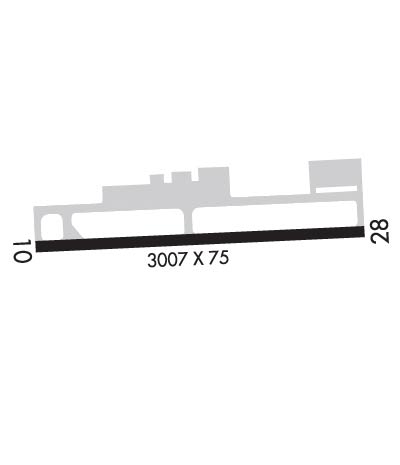
| Lat: N 3855.1 Long: W 07815.2 Elev: 704 Var: +10 Longest Runway: 3008 | ||
| AWOS: 121.85 CTAF: 123.0 | ||
| |||||||||||||||||||||||||||||||||||||||||||||||||||||||||||||
| |||||||||||||||||||||||||||||||||||||||||||||||||||||||||||||
| |||||||||||||||||||||||||||||||||||||||||||||||||||||||||||||
| Rwy | Rwy | |||||||
| 3008x75 | 3008' | 3008x75 | 3008' | |||||
| Runway ID | Single Wheel | Double Wheel | Double Tandem Wheel | Dual Double Wheel |
| 10/28 | 12,500 | N/A | N/A | N/A |
| These numbers are Advisory and are not limits. The Airport Manager should have more accurate Weight Limits | ||||
 Airport Diagram might not be current. | |
| Facility Name: | FRONT ROYAL-WARREN COUNTY |
| City Name: | FRONT ROYAL |
| County: | WARREN |
| State abbrev: | VA |
| State Name: | VIRGINIA |
| Ownership: | PUBLICLY OWNED |
| Use: | OPEN TO THE PUBLIC |
| Owner's Name: | COUNTY OF WARREN |
| Address: | 220 NORTH COMMERCE AVENUE, STE 100 |
| FRONT ROYAL, VA 22630 | |
| Owner's Phone: | 540-636-4600 |
| Manager's Name: | ROCK SKOWBO |
| Address: | 229 STOKES AIRPORT RD |
| FRONT ROYAL, VA 22630 | |
| Phone: | 540-635-3570 |
| FAA Region: | EASTERN |
| FAA Field Office: | DCA |
| Date | Sunrise | Sunset |
|---|---|---|
| 09/24/21 Friday | 7:02 | 19:07 |
| 09/25/21 Saturday | 7:03 | 19:06 |
| 09/26/21 Sunday | 7:04 | 19:04 |
| 09/27/21 Monday | 7:05 | 19:02 |
| 09/28/21 Tuesday | 7:06 | 19:01 |
| 09/29/21 Wednesday | 7:07 | 18:59 |
| 09/30/21 Thursday | 7:08 | 18:58 |
| 10/01/21 Friday | 7:09 | 18:56 |
| 10/02/21 Saturday | 7:10 | 18:55 |
| 10/03/21 Sunday | 7:11 | 18:53 |
| 10/04/21 Monday | 7:12 | 18:51 |
| 10/05/21 Tuesday | 7:12 | 18:50 |
| 10/06/21 Wednesday | 7:13 | 18:48 |
| 10/07/21 Thursday | 7:14 | 18:47 |
| Airport Attendance Schedule | MAY-SEP 7 Days A Week 0800-1700, OCT-APR 7 Days A Week 0900-1600 |
| Airport Status | OPERATIONAL (This Status can change at any time - please check NOTAMS) |
| Airport Lighting Schedule | ACTVT MIRL RWY 10/28 - CTAF. |
| Airport Storage Available | Tie Downs, Hanger |
| Extra Services Available | Charter, Glider, Flight Instruction, Aircraft Rental, Annual Surveying |
| Wind Indicator | YES - (lighted) |
| Control Tower | NO |
| CTAF Frequency | 123.000 |
| Unicom Frequency | 123.000 |
| Rotating Beacon Color | CLEAR-GREEN (Light Land Airport) |
| Segmented Circle | NO |
| Landing Fee | NO |
| Airport Inspected | STATE - performed by STATE AERONAUTICAL PERSONNEL |
| Inspection Date | 05/12/2021 |
| Type of Fuel Available | Grade 100LL |
| Airframe Repair Service | MINOR |
| Power Plant Repair Service | MINOR |
| Latitude | N3855.1 |
| Longitude | W07815.2 (ESTIMATED) |
| Arpt Elevation | 703ft (SURVEYED) |
| Magnetic Variation | 10W |
| 3 miles W | of FRONT ROYAL |
| Traffic Pattern Altitude | |
| Sectional Chart | WASHINGTON |
| Operations (Reported) | Yearly | Avg. Daily |
|---|---|---|
| General Aviation Transient | 7632 | 21 |
| General Aviation Local | 7632 | 21 |
| Air Taxi | 612 | 2 |
| Commerical | 0 | 0 |
| Commuter | 0 | 0 |
| Military | 458 | 1 |
| Aircraft based on Field | |
|---|---|
| General Aviation Singles | 24 |
| General Aviation Multi | 0 |
| Jet Aircraft | 0 |
| General Aviation Helicopters | 3 |
| Military Aircraft | 0 |
| Gliders | 20 |
| Ultralights | 2 |
| FSS on field | NO |
| FSS tie-in | LEESBURG |
| FSS Phone | 1-800-WX-BRIEF |
| Who issues Notams | DCA |
| Notam D service at airport | YES |
| ARTCC Name | WASHINGTON |
| Airport Certification | |
| Aircraft Rescue & Firefighting Index | None |
| Airport of Entry | No |
| Custom Landing Rights | No |
| Joint Civil/Military | No |
| Military Landing rights | No |
| NATIONAL PLAN OF INTEGRATED AIRPORT SYSTEMS (NPIAS) |
| GRANT AGREEMENTS UNDER FAAP/ADAP/AIP |
| ASSURANCES PURSUANT TO TITLE VI, CIVIL RIGHTS ACT OF 1964 |
| GLIDER OPNS ON & INVOF ARPT. |
| NOISE ABATEMENT PROCS IN EFCT, CTC ARPT MGR FOR DTLS AT 540-635-3570. |
| DEER & GEESE ON & INVOF ARPT. |
| FOR CD CTC POTOMAC APCH AT 866-709-4993. |
Airport Communications & Frequencies:
|
| Runway: 10 | Runway: 28 | ||
| Mag heading: | 97° | Mag heading: | 277° |
| Rwy Slope: | .35% Up | Rwy Slope: | -.35% Down |
| Approach: | Approach: | ||
| Pattern: | Left Traffic; RY 10 RIGHT TFC FOR GYROCOPTERS, ULTRALIGHTS & GLIDERS. | Pattern: | Left Traffic; RY 28 RIGHT TFC FOR GYROCOPTERS, ULTRALIGHTS & GLIDERS. |
| Markings: | BASIC | Markings: | NONPRECISION INSTRUMENT |
| Marking Condition: | FAIR | Marking Condition: | FAIR |
| Arresting Dev: | Arresting Dev: | ||
| Lat & Long: | N3855.0 W07815.5 | Lat. & Long.: | N3855.1 W07814.9 |
| Elev: | 693.0 ft. MSL | Elev: | 703.5 ft. MSL |
| TCH: | 16 ft. AGL | TCH: | 16 ft. AGL |
| Visual Glide Path: | 3.00 degrees | Visual Glide Path: | 3.00 degrees |
| Displaced Threshold: | No | Displaced Threshold: | No |
| Touchdown Zone: | YES | Touchdown Zone: | YES |
| Touchdown Elev.: | 703.6 feet | Touchdown Elev.: | 703.6 feet |
| Visual Glide Slope: | SYSTEM OF PANELS ON RIGHT SIDE OF RUNWAY (May NOT Be Lighted) | Visual Glide Slope: | SYSTEM OF PANELS ON LEFT SIDE OF RUNWAY (May NOT Be Lighted) |
| RVR Equipment: | RVR Equipment: | ||
| RVV Equipment: | NO | RVV Equipment: | NO |
| Approach Lights: | Approach Lights: | ||
| REIL: | NO | REIL: | NO |
| Centerline Lights: | NO | Centerline Lights: | NO |
| Touchdown lights: | NO | Touchdown lights: | NO |
| Runway Category: | Runway with a Visual Approach | Runway Category: | Runway with a Visual Approach |
| Declared Distances: | Declared Distances: | ||
| Obstructions: | ROAD | Obstructions: | POLE |
| Marked: | NOT Marked/Lighted | Marked: | NOT Marked/Lighted |
| Clearance slope: | 6:1 | Clearance slope: | 28:1 |
| Obstruction height: | 24 feet AGL | Obstruction height: | 42 feet AGL |
| Dist. from runway: | 350 feet | Dist. from runway: | 1382 feet |
| Centerline offset: | 131 left of centerline | Centerline offset: | 63 feet right of centerline |
| Comments: | Comments: |
Thanks for using FltPlan.com
all rights reserved © 1999-2021 by Flight Plan LLC