| FAIRMONT MUNI FAIRMONT MN |
| |
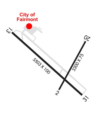
| Lat: N 4338.6 Long: W 09424.9 Elev: 1162 Var: -04 Longest Runway: 5503 | ||
| Clr Del: 127.75 AWOS: 110.2 CTAF: 122.8 | ||
| |||||||||||||||||||||||||||||||||||||||||||||||||||||||||||||
| |||||||||||||||||||||||||||||||||||||||||||||||||||||||||||||
| |||||||||||||||||||||||||||||||||||||||||||||||||||||||||||||
| Rwy | Rwy | |||||||
| 3300x75 | 3300' | 3300x75 | 3300' | |||||
| 5503x100 | 5503' | 5503x100 | 5503' | 111.10 - 310° | ||||
| Runway ID | Single Wheel | Double Wheel | Double Tandem Wheel | Dual Double Wheel |
| 02/20 | 12,000 | N/A | N/A | N/A |
| 13/31 | 35,000 | 40,000 | N/A | N/A |
| These numbers are Advisory and are not limits. The Airport Manager should have more accurate Weight Limits | ||||
 Airport Diagram might not be current. | |
| Facility Name: | FAIRMONT MUNI |
| City Name: | FAIRMONT |
| County: | MARTIN |
| State abbrev: | MN |
| State Name: | MINNESOTA |
| Ownership: | PUBLICLY OWNED |
| Use: | OPEN TO THE PUBLIC |
| Owner's Name: | CITY OF FAIRMONT |
| Address: | 100 DOWNTOWN PLAZA, PO BOX 751 |
| FAIRMONT, MN 56031 | |
| Owner's Phone: | 507-238-9461 |
| Manager's Name: | LEE STEINKAMP |
| Address: | 2159 EAST BLUE EARTH AVE |
| FAIRMONT, MN 56031 | |
| Phone: | 507-235-6160 |
| FAA Region: | GREAT LAKES |
| FAA Field Office: | DMA |
| Date | Sunrise | Sunset |
|---|---|---|
| 09/24/21 Friday | 7:07 | 19:12 |
| 09/25/21 Saturday | 7:08 | 19:10 |
| 09/26/21 Sunday | 7:09 | 19:08 |
| 09/27/21 Monday | 7:10 | 19:06 |
| 09/28/21 Tuesday | 7:11 | 19:04 |
| 09/29/21 Wednesday | 7:13 | 19:03 |
| 09/30/21 Thursday | 7:14 | 19:01 |
| 10/01/21 Friday | 7:15 | 18:59 |
| 10/02/21 Saturday | 7:16 | 18:57 |
| 10/03/21 Sunday | 7:17 | 18:55 |
| 10/04/21 Monday | 7:18 | 18:54 |
| 10/05/21 Tuesday | 7:20 | 18:52 |
| 10/06/21 Wednesday | 7:21 | 18:50 |
| 10/07/21 Thursday | 7:22 | 18:48 |
| Airport Attendance Schedule | MON-FRI 0800-1700 |
| Airport Status | OPERATIONAL (This Status can change at any time - please check NOTAMS) |
| Airport Lighting Schedule | HIRL RY 13/31 AND MIRL RY 02/20 PRESET TO LOW INTS, TO INCR INTS AND ACTVT MALSR RY 31; REIL RY 13, RY 02, & RY 20; PAPI RY 13, RY 31, RY 02, & RY 20 - CTAF. |
| Airport Storage Available | Tie Downs, Hanger |
| Extra Services Available | Crop Dusting, Aircraft Sales |
| Wind Indicator | YES - (lighted) |
| Control Tower | NO |
| CTAF Frequency | 122.800 |
| Unicom Frequency | 122.800 |
| Rotating Beacon Color | CLEAR-GREEN (Light Land Airport) |
| Segmented Circle | YES |
| Landing Fee | NO |
| Airport Inspected | FEDERAL - performed by STATE AERONAUTICAL PERSONNEL |
| Inspection Date | 08/12/2020 |
| Type of Fuel Available | Grade 100LL, JET A (freeze point -40C); -10JET A & 100LL AVBL 24 HRS WITH CREDIT CARD. |
| Airframe Repair Service | NONE |
| Power Plant Repair Service | NONE |
| Latitude | N4338.6 |
| Longitude | W09424.9 (ESTIMATED) |
| Arpt Elevation | 1161ft (SURVEYED) |
| Magnetic Variation | 04E |
| 2 miles SE | of FAIRMONT |
| Traffic Pattern Altitude | |
| Sectional Chart | OMAHA |
| Operations (Reported) | Yearly | Avg. Daily |
|---|---|---|
| General Aviation Transient | 5000 | 14 |
| General Aviation Local | 3600 | 10 |
| Air Taxi | 700 | 2 |
| Commerical | 0 | 0 |
| Commuter | 0 | 0 |
| Military | 100 | 0 |
| Aircraft based on Field | |
|---|---|
| General Aviation Singles | 28 |
| General Aviation Multi | 1 |
| Jet Aircraft | 0 |
| General Aviation Helicopters | 0 |
| Military Aircraft | 0 |
| Gliders | 0 |
| Ultralights | 0 |
| FSS on field | NO |
| FSS tie-in | PRINCETON |
| FSS Phone | 1-800-WX-BRIEF |
| Who issues Notams | FRM |
| Notam D service at airport | YES |
| ARTCC Name | MINNEAPOLIS |
| Airport Certification | |
| Aircraft Rescue & Firefighting Index | None |
| Airport of Entry | No |
| Custom Landing Rights | No |
| Joint Civil/Military | No |
| Military Landing rights | YES |
| NATIONAL PLAN OF INTEGRATED AIRPORT SYSTEMS (NPIAS) |
| GRANT AGREEMENTS UNDER FAAP/ADAP/AIP |
| ASSURANCES PURSUANT TO TITLE VI, CIVIL RIGHTS ACT OF 1964 |
| MIGRATORY BIRD HAZARD SPRING & FALL; GULLS ON & INVOF ARPT. |
| FOR TWY LGTS KEY 122.8 3 TIMES FOR 30% AND 7 TIMES FOR 100%. |
| FOR TRANSIENT STORAGE CONTACT AIRPORT MANAGER |
Airport Communications & Frequencies:
| |||||||||
| Runway: 02 | Runway: 20 | ||
| Mag heading: | 24° | Mag heading: | 204° |
| Rwy Slope: | -.03% Down | Rwy Slope: | .03% Up |
| Approach: | Approach: | ||
| Pattern: | Left Traffic | Pattern: | Left Traffic |
| Markings: | NONPRECISION INSTRUMENT | Markings: | NONPRECISION INSTRUMENT |
| Marking Condition: | GOOD | Marking Condition: | GOOD |
| Arresting Dev: | Arresting Dev: | ||
| Lat & Long: | N4338.4 W09424.9 | Lat. & Long.: | N4338.9 W09424.6 |
| Elev: | 1158.9 ft. MSL | Elev: | 1157.9 ft. MSL |
| TCH: | 25 ft. AGL | TCH: | 40 ft. AGL |
| Visual Glide Path: | 3.00 degrees | Visual Glide Path: | 3.00 degrees |
| Displaced Threshold: | No | Displaced Threshold: | No |
| Touchdown Zone: | YES | Touchdown Zone: | YES |
| Touchdown Elev.: | 1159.5 feet | Touchdown Elev.: | 1159.5 feet |
| Visual Glide Slope: | 4-Light PAPI on LEFT side of Runway | Visual Glide Slope: | 4-Light PAPI on LEFT side of Runway |
| RVR Equipment: | RVR Equipment: | ||
| RVV Equipment: | NO | RVV Equipment: | NO |
| Approach Lights: | Approach Lights: | ||
| REIL: | YES | REIL: | YES |
| Centerline Lights: | NO | Centerline Lights: | NO |
| Touchdown lights: | NO | Touchdown lights: | NO |
| Runway Category: | Runway with a Visual Approach | Runway Category: | Runway with a Visual Approach |
| Declared Distances: | Declared Distances: |
| Runway: 13 | Runway: 31 | ||
| Mag heading: | 130° | Mag heading: | 310° |
| Rwy Slope: | .04% Up | Rwy Slope: | -.04% Down |
| Approach: | Approach: | ILS | |
| Pattern: | Left Traffic | Pattern: | Left Traffic |
| Markings: | NONPRECISION INSTRUMENT | Markings: | PRECISION INSTRUMENT |
| Marking Condition: | GOOD | Marking Condition: | GOOD |
| Arresting Dev: | Arresting Dev: | ||
| Lat & Long: | N4339.0 W09425.5 | Lat. & Long.: | N4338.3 W09424.6 |
| Elev: | 1158.1 ft. MSL | Elev: | 1160.5 ft. MSL |
| TCH: | 43 ft. AGL | TCH: | 40 ft. AGL |
| Visual Glide Path: | 3.00 degrees | Visual Glide Path: | 3.00 degrees |
| Displaced Threshold: | No | Displaced Threshold: | No |
| Touchdown Zone: | YES | Touchdown Zone: | YES |
| Touchdown Elev.: | 1161.8 feet | Touchdown Elev.: | 1161.8 feet |
| Visual Glide Slope: | 4-Light PAPI on LEFT side of Runway | Visual Glide Slope: | 4-Light PAPI on LEFT side of Runway |
| RVR Equipment: | RVR Equipment: | ||
| RVV Equipment: | NO | RVV Equipment: | NO |
| Approach Lights: | Approach Lights: | MALSR - 1,400 foot medium intensity approach lighting system with runway alignment indicator lights | |
| REIL: | YES | REIL: | NO |
| Centerline Lights: | NO | Centerline Lights: | NO |
| Touchdown lights: | NO | Touchdown lights: | NO |
| Runway Category: | Runway with a Non-precision Approach having visibility minimums greater than 3/4 mile | Runway Category: | Precision Instrument Runway |
| Declared Distances: | Declared Distances: | ||
| Obstructions: | ROAD | Obstructions: | |
| Marked: | NOT Marked/Lighted | Marked: | |
| Clearance slope: | 22:1 | Clearance slope: | 50:1 |
| Obstruction height: | 9 feet AGL | Obstruction height: | |
| Dist. from runway: | 405 feet | Dist. from runway: | |
| Centerline offset: | 520 right of centerline | Centerline offset: | |
| Comments: | Comments: |
Thanks for using FltPlan.com
all rights reserved © 1999-2021 by Flight Plan LLC