
| FITCH H BEACH CHARLOTTE MI |
| |
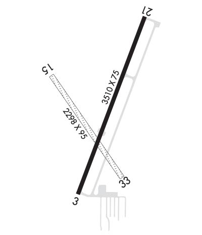
| Lat: N 4234.4 Long: W 08448.7 Elev: 891 Var: +06 Longest Runway: 3510 | ||
| AWOS: 118.07 CTAF: 123.0 | ||
| ||||||
| ||||||
|
| Rwy | Rwy | |||||||
| 3510x75 | 3510' | 3510x75 | 3510' | |||||
| 2298x95 | 1538' | 2298x95 | 2105' | |||||
| Runway ID | Single Wheel | Double Wheel | Double Tandem Wheel | Dual Double Wheel |
| 03/21 | 26,000 | N/A | N/A | N/A |
| 15/33 | N/A | N/A | N/A | N/A |
| These numbers are Advisory and are not limits. The Airport Manager should have more accurate Weight Limits | ||||
 Airport Diagram might not be current. | |
| Facility Name: | FITCH H BEACH |
| City Name: | CHARLOTTE |
| County: | EATON |
| State abbrev: | MI |
| State Name: | MICHIGAN |
| Ownership: | PUBLICLY OWNED |
| Use: | OPEN TO THE PUBLIC |
| Owner's Name: | CITY OF CHARLOTTE/CITY MANAGER |
| Address: | 111 E LAWRENCE AVE |
| CHARLOTTE, MI 48813 | |
| Owner's Phone: | 517-543-2750 |
| Manager's Name: | TODD COTTER |
| Address: | 111 E LAWRENCE AVE |
| CHARLOTTE, MI 48813 | |
| Phone: | 517-712-8177 |
| FAA Region: | GREAT LAKES |
| FAA Field Office: | DET |
| Date | Sunrise | Sunset |
|---|---|---|
| 09/24/21 Friday | 7:28 | 19:33 |
| 09/25/21 Saturday | 7:30 | 19:32 |
| 09/26/21 Sunday | 7:31 | 19:30 |
| 09/27/21 Monday | 7:32 | 19:28 |
| 09/28/21 Tuesday | 7:33 | 19:26 |
| 09/29/21 Wednesday | 7:34 | 19:25 |
| 09/30/21 Thursday | 7:35 | 19:23 |
| 10/01/21 Friday | 7:36 | 19:21 |
| 10/02/21 Saturday | 7:37 | 19:19 |
| 10/03/21 Sunday | 7:38 | 19:18 |
| 10/04/21 Monday | 7:39 | 19:16 |
| 10/05/21 Tuesday | 7:41 | 19:14 |
| 10/06/21 Wednesday | 7:42 | 19:12 |
| 10/07/21 Thursday | 7:43 | 19:11 |
| Airport Attendance Schedule | 7 Days A Week 0800-1700; ARPT UNATNDD MAJ HOLS |
| Airport Status | OPERATIONAL (This Status can change at any time - please check NOTAMS) |
| Airport Lighting Schedule | ACTVT REIL RWY 03/21; PAPI RWY 03 & 21; MIRL RWY 03/21 - CTAF. |
| Airport Storage Available | Tie Downs, Hanger |
| Extra Services Available | Flight Instruction, Aircraft Rental |
| Wind Indicator | YES - (lighted) |
| Control Tower | NO |
| CTAF Frequency | 123.000 |
| Unicom Frequency | 123.000 |
| Rotating Beacon Color | CLEAR-GREEN (Light Land Airport) |
| Segmented Circle | YES |
| Landing Fee | NO |
| Airport Inspected | STATE - performed by STATE AERONAUTICAL PERSONNEL |
| Inspection Date | 10/17/2019 |
| Type of Fuel Available | Grade 100LL |
| Airframe Repair Service | MAJOR |
| Power Plant Repair Service | MAJOR |
| Latitude | N4234.4 |
| Longitude | W08448.7 (ESTIMATED) |
| Arpt Elevation | 891ft (SURVEYED) |
| Magnetic Variation | 06W |
| 2 miles NE | of CHARLOTTE |
| Traffic Pattern Altitude | |
| Sectional Chart | DETROIT |
| Operations (Reported) | Yearly | Avg. Daily |
|---|---|---|
| General Aviation Transient | 6570 | 18 |
| General Aviation Local | 4190 | 11 |
| Air Taxi | 0 | 0 |
| Commerical | 0 | 0 |
| Commuter | 0 | 0 |
| Military | 480 | 1 |
| Aircraft based on Field | |
|---|---|
| General Aviation Singles | 18 |
| General Aviation Multi | 2 |
| Jet Aircraft | 0 |
| General Aviation Helicopters | 0 |
| Military Aircraft | 0 |
| Gliders | 0 |
| Ultralights | 0 |
| FSS on field | NO |
| FSS tie-in | LANSING |
| FSS Phone | 1-800-WX-BRIEF |
| Who issues Notams | FPK |
| Notam D service at airport | YES |
| ARTCC Name | CLEVELAND |
| Airport Certification | |
| Aircraft Rescue & Firefighting Index | None |
| Airport of Entry | No |
| Custom Landing Rights | No |
| Joint Civil/Military | No |
| Military Landing rights | YES |
| NATIONAL PLAN OF INTEGRATED AIRPORT SYSTEMS (NPIAS) |
| GRANT AGREEMENTS UNDER FAAP/ADAP/AIP |
| ASSURANCES PURSUANT TO TITLE VI, CIVIL RIGHTS ACT OF 1964 |
| MIL HELI OPS ON & INVOF ARPT PARTICULARLY AT NGT. |
| BIRDS & DEER ON RWYS. |
| GND MOLE AND WATERFOWL ON RWY 15/33. |
| FOR CD CTC GREAT LAKES APCH AT 269-459-3345. WHEN APCH CLSD, FOR CD CTC CLEVELAND ARTCC AT 440-774-0490. |
| AIRCRAFT WO RADIO OPRG INVOF ARPT. |
| RWY 15/3 3 CLSD DEC-MAR & WHEN SNOW COVERED. |
Airport Communications & Frequencies:
| |||||||||||||||||
| Runway: 03 | Runway: 21 | ||
| Mag heading: | 27° | Mag heading: | 207° |
| Rwy Slope: | .32% Up | Rwy Slope: | -.32% Down |
| Approach: | Approach: | ||
| Pattern: | Left Traffic | Pattern: | Left Traffic |
| Markings: | NONPRECISION INSTRUMENT | Markings: | NONPRECISION INSTRUMENT |
| Marking Condition: | POOR; RWY PAINT MARKINGS FADED. | Marking Condition: | POOR; RWY PAINT MARKINGS FADED. |
| Arresting Dev: | Arresting Dev: | ||
| Lat & Long: | N4234.2 W08448.8 | Lat. & Long.: | N4234.7 W08448.5 |
| Elev: | 879.7 ft. MSL | Elev: | 891.0 ft. MSL |
| TCH: | 40 ft. AGL | TCH: | 40 ft. AGL |
| Visual Glide Path: | 4.00 degrees | Visual Glide Path: | 4.00 degrees |
| Displaced Threshold: | No | Displaced Threshold: | No |
| Touchdown Zone: | YES | Touchdown Zone: | YES |
| Touchdown Elev.: | 888.5 feet | Touchdown Elev.: | 891.0 feet |
| Visual Glide Slope: | 4-Light PAPI on LEFT side of Runway | Visual Glide Slope: | 4-Light PAPI on LEFT side of Runway |
| RVR Equipment: | RVR Equipment: | ||
| RVV Equipment: | NO | RVV Equipment: | NO |
| Approach Lights: | Approach Lights: | ||
| REIL: | YES | REIL: | YES |
| Centerline Lights: | NO | Centerline Lights: | NO |
| Touchdown lights: | NO | Touchdown lights: | NO |
| Runway Category: | Runway with a Visual Approach | Runway Category: | Runway with a Non-precision Approach |
| Declared Distances: | Declared Distances: | ||
| Obstructions: | TREE | Obstructions: | TREES |
| Marked: | NOT Marked/Lighted | Marked: | NOT Marked/Lighted |
| Clearance slope: | 33:1 | Clearance slope: | 15:1 |
| Obstruction height: | 70 feet AGL | Obstruction height: | 105 feet AGL |
| Dist. from runway: | 2505 feet | Dist. from runway: | 1802 feet |
| Centerline offset: | 115 left of centerline | Centerline offset: | 481 feet right of centerline |
| Comments: | Comments: |
| Runway: 15 | Runway: 33 | ||
| Mag heading: | 151° | Mag heading: | 331° |
| Rwy Slope: | .03% Up | Rwy Slope: | -.03% Down |
| Approach: | Approach: | ||
| Pattern: | Left Traffic | Pattern: | Left Traffic |
| Markings: | Markings: | ||
| Marking Condition: | 15/33 THR & DSPLCD THR MKD WITH 3 FT YELLOW CONES. | Marking Condition: | |
| Arresting Dev: | Arresting Dev: | ||
| Lat & Long: | N4234.6 W08448.9 | Lat. & Long.: | N4234.3 W08448.6 |
| Elev: | 879.5 ft. MSL | Elev: | 880.3 ft. MSL |
| TCH: | TCH: | ||
| Visual Glide Path: | Visual Glide Path: | ||
| Displaced Threshold: | 760 feet | Displaced Threshold: | 193 feet |
| Touchdown Zone: | YES | Touchdown Zone: | YES |
| Touchdown Elev.: | 881.4 feet | Touchdown Elev.: | 881.4 feet |
| Visual Glide Slope: | Visual Glide Slope: | ||
| RVR Equipment: | RVR Equipment: | ||
| RVV Equipment: | NO | RVV Equipment: | NO |
| Approach Lights: | Approach Lights: | ||
| REIL: | NO | REIL: | NO |
| Centerline Lights: | NO | Centerline Lights: | NO |
| Touchdown lights: | NO | Touchdown lights: | NO |
| Runway Category: | Runway with a Visual Approach | Runway Category: | Runway with a Visual Approach |
| Declared Distances: | Declared Distances: | ||
| Obstructions: | TREES | Obstructions: | ROAD |
| Marked: | NOT Marked/Lighted | Marked: | NOT Marked/Lighted |
| Clearance slope: | 12:1; APCH RATIO 20:1 AT DSPLCD THR. | Clearance slope: | 12:1; APCH RATIO 20:1 AT DSPLCD THR. |
| Obstruction height: | 85 feet AGL | Obstruction height: | 10 feet AGL |
| Dist. from runway: | 1020 feet | Dist. from runway: | 127 feet |
| Centerline offset: | 100B | Centerline offset: | 48 feet left of centerline |
| Comments: | Comments: |
Thanks for using FltPlan.com
all rights reserved © 1999-2021 by Flight Plan LLC