
| ROHNERVILLE FORTUNA CA |
| |
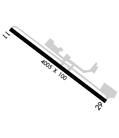
| Lat: N 4033.2 Long: W 12408.0 Elev: 393 Var: -17 Longest Runway: 4005 | ||
| AWOS: 133.8 CTAF: 122.9 | ||
| ||||||
| ||||||
|
| Rwy | Rwy | |||||||
| 4005x100 | 4005' | 4005x100 | 4005' | |||||
| Runway ID | Single Wheel | Double Wheel | Double Tandem Wheel | Dual Double Wheel |
| 11/29 | 30,000 | N/A | N/A | N/A |
| These numbers are Advisory and are not limits. The Airport Manager should have more accurate Weight Limits | ||||
 Airport Diagram might not be current. | |
| Facility Name: | ROHNERVILLE |
| City Name: | FORTUNA |
| County: | HUMBOLDT |
| State abbrev: | CA |
| State Name: | CALIFORNIA |
| Ownership: | PUBLICLY OWNED |
| Use: | OPEN TO THE PUBLIC |
| Owner's Name: | HUMBOLDT COUNTY |
| Address: | 1106 2ND ST |
| EUREKA, CA 95501 | |
| Owner's Phone: | 707-839-5401 |
| Manager's Name: | CODY ROGGATZ; ARPT MANAGER LOCATED AT CA REDWOOD COAST-HUMBOLDT COUNTY ARPT. |
| Address: | 3561 BOEING AVE. |
| MCKINLEYVILLE, CA 95519 | |
| Phone: | (707) 839-5402 |
| FAA Region: | WESTERN-PACIFIC |
| FAA Field Office: | SFO |
| Date | Sunrise | Sunset |
|---|---|---|
| 09/24/21 Friday | 7:06 | 19:11 |
| 09/25/21 Saturday | 7:07 | 19:09 |
| 09/26/21 Sunday | 7:08 | 19:07 |
| 09/27/21 Monday | 7:09 | 19:05 |
| 09/28/21 Tuesday | 7:10 | 19:04 |
| 09/29/21 Wednesday | 7:11 | 19:02 |
| 09/30/21 Thursday | 7:12 | 19:01 |
| 10/01/21 Friday | 7:13 | 18:59 |
| 10/02/21 Saturday | 7:14 | 18:57 |
| 10/03/21 Sunday | 7:15 | 18:56 |
| 10/04/21 Monday | 7:16 | 18:54 |
| 10/05/21 Tuesday | 7:17 | 18:52 |
| 10/06/21 Wednesday | 7:18 | 18:51 |
| 10/07/21 Thursday | 7:19 | 18:49 |
| Airport Attendance Schedule | UNATTENDED |
| Airport Status | OPERATIONAL (This Status can change at any time - please check NOTAMS) |
| Airport Lighting Schedule | ACTVT REIL RWY 11 & 29; MIRL RWY 11/29 - CTAF.; DUSK-DAWN |
| Airport Storage Available | Tie Downs |
| Extra Services Available | NONE |
| Wind Indicator | YES - (lighted) |
| Control Tower | NO |
| CTAF Frequency | 122.900 |
| Unicom Frequency | |
| Rotating Beacon Color | CLEAR-GREEN (Light Land Airport) |
| Segmented Circle | YES |
| Landing Fee | NO |
| Airport Inspected | STATE - performed by STATE AERONAUTICAL PERSONNEL |
| Inspection Date | 01/20/2021 |
| Type of Fuel Available | Grade 100LL |
| Airframe Repair Service | None |
| Power Plant Repair Service | None |
| Latitude | N4033.2 |
| Longitude | W12408.0 (ESTIMATED) |
| Arpt Elevation | 392ft (SURVEYED) |
| Magnetic Variation | 17E |
| 3 miles SE | of FORTUNA |
| Traffic Pattern Altitude | 800 |
| Sectional Chart | KLAMATH FALLS |
| Operations (Reported) | Yearly | Avg. Daily |
|---|---|---|
| General Aviation Transient | 10000 | 27 |
| General Aviation Local | 15000 | 41 |
| Air Taxi | 0 | 0 |
| Commerical | 0 | 0 |
| Commuter | 0 | 0 |
| Military | 0 | 0 |
| Aircraft based on Field | |
|---|---|
| General Aviation Singles | 3 |
| General Aviation Multi | 0 |
| Jet Aircraft | 0 |
| General Aviation Helicopters | 0 |
| Military Aircraft | 0 |
| Gliders | 0 |
| Ultralights | 0 |
| FSS on field | NO |
| FSS tie-in | OAKLAND |
| FSS Phone | 1-800-WX-BRIEF |
| Who issues Notams | FOT |
| Notam D service at airport | YES |
| ARTCC Name | SEATTLE |
| Airport Certification | |
| Aircraft Rescue & Firefighting Index | None |
| Airport of Entry | No |
| Custom Landing Rights | No |
| Joint Civil/Military | No |
| Military Landing rights | YES |
| NATIONAL PLAN OF INTEGRATED AIRPORT SYSTEMS (NPIAS) |
| GRANT AGREEMENTS UNDER FAAP/ADAP/AIP |
| ASSURANCES PURSUANT TO TITLE VI, CIVIL RIGHTS ACT OF 1964 |
| THIS AIRPORT HAS BEEN SURVEYED BY THE NATIONAL GEODETIC SURVEY. |
| USFS AND CDF FIRE RETARDENT STATION. |
| DEER INVOF OF RYS. |
| FOR CD CTC SEATTLE ARTCC AT 253-351-3694. |
Airport Communications & Frequencies:
| |||||||
| Runway: 11 | Runway: 29 | ||
| Mag heading: | 110° | Mag heading: | 290° |
| Rwy Slope: | 1.31% Up | Rwy Slope: | -1.31% Down |
| Approach: | Approach: | ||
| Pattern: | Right Traffic | Pattern: | Left Traffic |
| Markings: | NONPRECISION INSTRUMENT | Markings: | NONPRECISION INSTRUMENT |
| Marking Condition: | FAIR | Marking Condition: | FAIR |
| Arresting Dev: | Arresting Dev: | ||
| Lat & Long: | N4033.4 W12408.3 | Lat. & Long.: | N4033.0 W12407.6 |
| Elev: | 340.4 ft. MSL | Elev: | 392.7 ft. MSL |
| TCH: | 45 ft. AGL | TCH: | |
| Visual Glide Path: | 3.00 degrees | Visual Glide Path: | |
| Displaced Threshold: | No | Displaced Threshold: | No |
| Touchdown Zone: | YES | Touchdown Zone: | YES |
| Touchdown Elev.: | 381.8 feet | Touchdown Elev.: | 392.7 feet |
| Visual Glide Slope: | 4-BOX VASI ON RIGHT SIDE OF RUNWAY | Visual Glide Slope: | |
| RVR Equipment: | RVR Equipment: | ||
| RVV Equipment: | NO | RVV Equipment: | NO |
| Approach Lights: | Approach Lights: | ||
| REIL: | YES | REIL: | YES |
| Centerline Lights: | NO | Centerline Lights: | NO |
| Touchdown lights: | NO | Touchdown lights: | NO |
| Runway Category: | Runway with a Non-precision Approach having visibility minimums greater than 3/4 mile | Runway Category: | Runway with a Non-precision Approach having visibility minimums greater than 3/4 mile |
| Declared Distances: | Declared Distances: |
Thanks for using FltPlan.com
all rights reserved © 1999-2021 by Flight Plan LLC
