
| FLORA MUNI FLORA IL |
| |
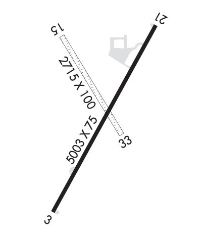
| Lat: N 3839.9 Long: W 08827.2 Elev: 473 Var: +01 Longest Runway: 5003 | ||
| AWOS: 120.17 CTAF: 122.7 | ||
| ||||||
| ||||||
|
| Rwy | Rwy | |||||||
| 5003x75 | 5003' | 5003x75 | 5003' | 108.55 - 210° | ||||
| 2715x100 | 2511' | 2715x100 | 2541' | |||||
| Runway ID | Single Wheel | Double Wheel | Double Tandem Wheel | Dual Double Wheel |
| 03/21 | 30,000 | 40,000 | N/A | N/A |
| 15/33 | N/A | N/A | N/A | N/A |
| These numbers are Advisory and are not limits. The Airport Manager should have more accurate Weight Limits | ||||
 Airport Diagram might not be current. | |
| Facility Name: | FLORA MUNI |
| City Name: | FLORA |
| County: | CLAY |
| State abbrev: | IL |
| State Name: | ILLINOIS |
| Ownership: | PUBLICLY OWNED |
| Use: | OPEN TO THE PUBLIC |
| Owner's Name: | FLORA AIRPORT AUTHORITY |
| Address: | ONE AIRPORT ROAD |
| FLORA, IL 62839 | |
| Owner's Phone: | 618-662-2174 |
| Manager's Name: | KAREN PICKEL |
| Address: | ONE AIRPORT ROAD |
| FLORA, IL 62839 | |
| Phone: | 618-662-2823 |
| FAA Region: | GREAT LAKES |
| FAA Field Office: | CHI |
| Date | Sunrise | Sunset |
|---|---|---|
| 09/24/21 Friday | 6:43 | 18:48 |
| 09/25/21 Saturday | 6:44 | 18:46 |
| 09/26/21 Sunday | 6:45 | 18:45 |
| 09/27/21 Monday | 6:46 | 18:43 |
| 09/28/21 Tuesday | 6:47 | 18:42 |
| 09/29/21 Wednesday | 6:48 | 18:40 |
| 09/30/21 Thursday | 6:49 | 18:38 |
| 10/01/21 Friday | 6:49 | 18:37 |
| 10/02/21 Saturday | 6:50 | 18:35 |
| 10/03/21 Sunday | 6:51 | 18:34 |
| 10/04/21 Monday | 6:52 | 18:32 |
| 10/05/21 Tuesday | 6:53 | 18:31 |
| 10/06/21 Wednesday | 6:54 | 18:29 |
| 10/07/21 Thursday | 6:55 | 18:28 |
| Airport Attendance Schedule | MON-FRI 0800-1630 |
| Airport Status | OPERATIONAL (This Status can change at any time - please check NOTAMS) |
| Airport Lighting Schedule | MIRL RY 03/21 PRESET ON LOW INTST; TO INCR INTST & ACTVT REIL RY 21; PLASI RYS 03/21 & TWY LGTS - CTAF. |
| Airport Storage Available | Tie Downs, Hanger |
| Extra Services Available | Aircraft Rental |
| Wind Indicator | YES - (lighted) |
| Control Tower | NO |
| CTAF Frequency | 122.700 |
| Unicom Frequency | 122.700 |
| Rotating Beacon Color | CLEAR-GREEN (Light Land Airport) |
| Segmented Circle | NO |
| Landing Fee | NO |
| Airport Inspected | STATE - performed by STATE AERONAUTICAL PERSONNEL |
| Inspection Date | 08/10/2018 |
| Type of Fuel Available | Grade 100LL, JET A (freeze point -40C); -10FUEL SELF SVC WITH CREDIT CARD. |
| Airframe Repair Service | NONE |
| Power Plant Repair Service | NONE |
| Latitude | N3839.9 |
| Longitude | W08827.2 (ESTIMATED) |
| Arpt Elevation | 472ft (SURVEYED) |
| Magnetic Variation | 01W |
| 2 miles E | of FLORA |
| Traffic Pattern Altitude | |
| Sectional Chart | ST LOUIS |
| Operations (Reported) | Yearly | Avg. Daily |
|---|---|---|
| General Aviation Transient | 3500 | 10 |
| General Aviation Local | 6000 | 16 |
| Air Taxi | 500 | 1 |
| Commerical | 0 | 0 |
| Commuter | 0 | 0 |
| Military | 0 | 0 |
| Aircraft based on Field | |
|---|---|
| General Aviation Singles | 5 |
| General Aviation Multi | 0 |
| Jet Aircraft | 0 |
| General Aviation Helicopters | 5 |
| Military Aircraft | 0 |
| Gliders | 0 |
| Ultralights | 0 |
| FSS on field | NO |
| FSS tie-in | SAINT LOUIS |
| FSS Phone | 1-800-WX-BRIEF |
| Who issues Notams | FOA |
| Notam D service at airport | YES |
| ARTCC Name | KANSAS CITY |
| Airport Certification | |
| Aircraft Rescue & Firefighting Index | None |
| Airport of Entry | No |
| Custom Landing Rights | No |
| Joint Civil/Military | No |
| Military Landing rights | YES |
| NATIONAL PLAN OF INTEGRATED AIRPORT SYSTEMS (NPIAS) |
| GRANT AGREEMENTS UNDER FAAP/ADAP/AIP |
| ASSURANCES PURSUANT TO TITLE VI, CIVIL RIGHTS ACT OF 1964 |
| RY 15/33 SOFT WHEN WET. |
| FOR CD CTC KANSAS CITY ARTCC AT 913-254-8508. |
Airport Communications & Frequencies:
| |||||||||
| Runway: 03 | Runway: 21 | ||
| Mag heading: | 31° | Mag heading: | 211° |
| Rwy Slope: | -.13% Down | Rwy Slope: | .13% Up |
| Approach: | Approach: | LOC/DME | |
| Pattern: | Left Traffic | Pattern: | Left Traffic |
| Markings: | NONPRECISION INSTRUMENT | Markings: | NONPRECISION INSTRUMENT |
| Marking Condition: | FAIR | Marking Condition: | FAIR |
| Arresting Dev: | Arresting Dev: | ||
| Lat & Long: | N3839.5 W08827.4 | Lat. & Long.: | N3840.2 W08826.9 |
| Elev: | 472.5 ft. MSL | Elev: | 466.1 ft. MSL |
| TCH: | 23 ft. AGL | TCH: | 25 ft. AGL |
| Visual Glide Path: | 3.00 degrees | Visual Glide Path: | 3.00 degrees |
| Displaced Threshold: | No | Displaced Threshold: | No |
| Touchdown Zone: | YES | Touchdown Zone: | YES |
| Touchdown Elev.: | 472.6 feet | Touchdown Elev.: | 470.2 feet |
| Visual Glide Slope: | PULSATING/STEADY BURNING VASI ON LEFT SIDE OF RUNWAY | Visual Glide Slope: | PULSATING/STEADY BURNING VASI ON LEFT SIDE OF RUNWAY |
| RVR Equipment: | RVR Equipment: | ||
| RVV Equipment: | NO | RVV Equipment: | NO |
| Approach Lights: | Approach Lights: | ||
| REIL: | NO | REIL: | YES |
| Centerline Lights: | NO | Centerline Lights: | NO |
| Touchdown lights: | NO | Touchdown lights: | NO |
| Runway Category: | Runway with a Non-precision Approach having visibility minimums greater than 3/4 mile | Runway Category: | Runway with a Non-precision Approach having visibility minimums greater than 3/4 mile |
| Declared Distances: | Declared Distances: | ||
| Obstructions: | TREE | Obstructions: | TREE |
| Marked: | NOT Marked/Lighted | Marked: | NOT Marked/Lighted |
| Clearance slope: | 34:1 | Clearance slope: | 34:1 |
| Obstruction height: | 73 feet AGL | Obstruction height: | 46 feet AGL |
| Dist. from runway: | 2708 feet | Dist. from runway: | 1780 feet |
| Centerline offset: | 94 right of centerline | Centerline offset: | 62 feet left of centerline |
| Comments: | Comments: |
| Runway: 15 | Runway: 33 | ||
| Mag heading: | 151° | Mag heading: | 331° |
| Rwy Slope: | -.26% Down | Rwy Slope: | .26% Up |
| Approach: | Approach: | ||
| Pattern: | Left Traffic | Pattern: | Left Traffic |
| Markings: | Markings: | ||
| Marking Condition: | RWY 15 /33 THLDS & BOUNDARY OUTLINED BY WHITE 1/2 TIRES. DAY USE ONLY. | Marking Condition: | |
| Arresting Dev: | Arresting Dev: | ||
| Lat & Long: | N3840.2 W08827.4 | Lat. & Long.: | N3839.8 W08827.1 |
| Elev: | 472.2 ft. MSL | Elev: | 465.2 ft. MSL |
| TCH: | TCH: | ||
| Visual Glide Path: | Visual Glide Path: | ||
| Displaced Threshold: | 204 feet | Displaced Threshold: | 174 feet |
| Touchdown Zone: | YES | Touchdown Zone: | YES |
| Touchdown Elev.: | 470.3 feet | Touchdown Elev.: | 472.2 feet |
| Visual Glide Slope: | Visual Glide Slope: | ||
| RVR Equipment: | RVR Equipment: | ||
| RVV Equipment: | NO | RVV Equipment: | NO |
| Approach Lights: | Approach Lights: | ||
| REIL: | NO | REIL: | NO |
| Centerline Lights: | NO | Centerline Lights: | NO |
| Touchdown lights: | NO | Touchdown lights: | NO |
| Runway Category: | Runway with a Visual Approach | Runway Category: | Runway with a Visual Approach |
| Declared Distances: | Declared Distances: | ||
| Obstructions: | TREE | Obstructions: | |
| Marked: | NOT Marked/Lighted | Marked: | |
| Clearance slope: | 13:1; APCH SLOPE 17:1 TO DSPLCD THR. | Clearance slope: | 20:1 |
| Obstruction height: | 46 feet AGL | Obstruction height: | |
| Dist. from runway: | 611 feet | Dist. from runway: | |
| Centerline offset: | Centerline offset: | ||
| Comments: | Comments: |
Thanks for using FltPlan.com
all rights reserved © 1999-2021 by Flight Plan LLC
