
| FOUR CORNERS RGNL FARMINGTON NM |
| |
| Lat: N 3644.5 Long: W 10813.8 Elev: 5507 Var: -12 Longest Runway: 6704 | ||
| Dept. ATIS: 127.15 Arr. ATIS: 127.15 Ground: 121.7 Tower: 118.9 | ||
| ||||||||||||||||||||||||||||||||||||||||||||||||||||||||||||||||||||
| ||||||||||||||||||||||||||||||||||||||||||||||||||||||||||||||||||||
| ||||||||||||||||||||||||||||||||||||||||||||||||||||||||||||||||||||
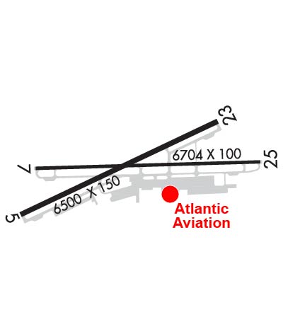
| Rwy | Rwy | |||||||
| 6501x150 | 6501' | 6501x150 | 5990' | |||||
| 6704x100 | 6465' | 6704x100 | 6487' | 111.90 - 256° | ||||
| Runway ID | Single Wheel | Double Wheel | Double Tandem Wheel | Dual Double Wheel |
| 05/23 | 47,000 | 66,000 | N/A | N/A |
| 07/25 | 50,000 | 90,000 | N/A | N/A |
| These numbers are Advisory and are not limits. The Airport Manager should have more accurate Weight Limits | ||||
 Airport Diagram might not be current. | |
| Facility Name: | FOUR CORNERS RGNL |
| City Name: | FARMINGTON |
| County: | SAN JUAN |
| State abbrev: | NM |
| State Name: | NEW MEXICO |
| Ownership: | PUBLICLY OWNED |
| Use: | OPEN TO THE PUBLIC |
| Owner's Name: | CITY OF FARMINGTON |
| Address: | 800 MUNICIPAL DRIVE |
| FARMINGTON, NM 87401 | |
| Owner's Phone: | 505-599-1100 |
| Manager's Name: | MICHAEL LEWIS |
| Address: | 800 MUNICIPAL DRIVE |
| FARMINGTON, NM 87401 | |
| Phone: | 505-599-1394 |
| FAA Region: | SOUTHWEST |
| FAA Field Office: | LNM |
| Date | Sunrise | Sunset |
|---|---|---|
| 09/24/21 Friday | 7:02 | 19:07 |
| 09/25/21 Saturday | 7:03 | 19:06 |
| 09/26/21 Sunday | 7:04 | 19:04 |
| 09/27/21 Monday | 7:05 | 19:03 |
| 09/28/21 Tuesday | 7:06 | 19:01 |
| 09/29/21 Wednesday | 7:06 | 19:00 |
| 09/30/21 Thursday | 7:07 | 18:58 |
| 10/01/21 Friday | 7:08 | 18:57 |
| 10/02/21 Saturday | 7:09 | 18:55 |
| 10/03/21 Sunday | 7:10 | 18:54 |
| 10/04/21 Monday | 7:11 | 18:52 |
| 10/05/21 Tuesday | 7:11 | 18:51 |
| 10/06/21 Wednesday | 7:12 | 18:49 |
| 10/07/21 Thursday | 7:13 | 18:48 |
| Airport Attendance Schedule | 7 Days A Week 0600-2200 |
| Airport Status | OPERATIONAL (This Status can change at any time - please check NOTAMS) |
| Airport Lighting Schedule | WHEN ATCT CLSD REIL RY 25 & MIRL RY 07/25 PRESET LOW INTST. TO INCR INTST & ACTVT REIL RY 23/25 & MIRL RY 05/23 - CTAF. |
| Airport Storage Available | Tie Downs, Hanger |
| Extra Services Available | Air Freight, Air Ambulance, Cargo Handling, Charter, Flight Instruction, Aircraft Rental, Aircraft Sales |
| Wind Indicator | YES - (lighted) |
| Control Tower | YES |
| CTAF Frequency | 118.900 |
| Unicom Frequency | 122.950 |
| Rotating Beacon Color | CLEAR-GREEN (Light Land Airport) |
| Segmented Circle | YES |
| Landing Fee | NO |
| Airport Inspected | FEDERAL - performed by FAA AIRPORTS FIELD PERSONNEL |
| Inspection Date | 08/27/2020 |
| Type of Fuel Available | Grade 100LL, JET A (freeze point -40C), JET A-1 (icing inhibitor, freeze point -50C) |
| Airframe Repair Service | MAJOR |
| Power Plant Repair Service | MAJOR |
| Latitude | N3644.5 |
| Longitude | W10813.8 (ESTIMATED) |
| Arpt Elevation | 5506ft (SURVEYED) |
| Magnetic Variation | 12E |
| 1 miles NW | of FARMINGTON |
| Traffic Pattern Altitude | |
| Sectional Chart | DENVER |
| Operations (Reported) | Yearly | Avg. Daily |
|---|---|---|
| General Aviation Transient | 11286 | 31 |
| General Aviation Local | 17909 | 49 |
| Air Taxi | 6140 | 17 |
| Commerical | 0 | 0 |
| Commuter | 0 | 0 |
| Military | 1049 | 3 |
| Aircraft based on Field | |
|---|---|
| General Aviation Singles | 70 |
| General Aviation Multi | 10 |
| Jet Aircraft | 1 |
| General Aviation Helicopters | 4 |
| Military Aircraft | 0 |
| Gliders | 0 |
| Ultralights | 2 |
| FSS on field | NO |
| FSS tie-in | ALBUQUERQUE |
| FSS Phone | 1-800-WX-BRIEF |
| Who issues Notams | FMN |
| Notam D service at airport | YES |
| ARTCC Name | DENVER |
| Airport Certification | AIRPORT RECEIVING SCHEDULED AIR CARRIER SERVICE FROM CARRIERS CERTIFICATED BY THE CIVIL AERONAUTICS BOARD |
| Aircraft Rescue & Firefighting Index | AIRPORT HAS A CERTIFICATE UNDER CFR PART 139 |
| Airport of Entry | No |
| Custom Landing Rights | No |
| Joint Civil/Military | No |
| Military Landing rights | YES |
| NATIONAL PLAN OF INTEGRATED AIRPORT SYSTEMS (NPIAS) |
| GRANT AGREEMENTS UNDER FAAP/ADAP/AIP |
| ADVANCE PLANNING AGREEMENT UNDER FAAP |
| ASSURANCES PURSUANT TO TITLE VI, CIVIL RIGHTS ACT OF 1964 |
| FOR CD CTC FARMINGTON ATCT GROUND CONTROL 121.7, WHEN ATCT CLSD CTC DENVER ARTCC AT 303-651-4257 |
Airport Communications & Frequencies:
| |||||||||||||||||||||
| Runway: 05 | Runway: 23 | ||
| Mag heading: | 53° | Mag heading: | 233° |
| Rwy Slope: | .49% Up | Rwy Slope: | -.49% Down |
| Approach: | Approach: | ||
| Pattern: | Left Traffic | Pattern: | Left Traffic |
| Markings: | NONPRECISION INSTRUMENT | Markings: | NONPRECISION INSTRUMENT |
| Marking Condition: | GOOD | Marking Condition: | GOOD |
| Arresting Dev: | Arresting Dev: | ||
| Lat & Long: | N3644.2 W10814.5 | Lat. & Long.: | N3644.7 W10813.3 |
| Elev: | 5471.6 ft. MSL | Elev: | 5503.7 ft. MSL |
| TCH: | 61 ft. AGL | TCH: | 42 ft. AGL |
| Visual Glide Path: | 3.00 degrees | Visual Glide Path: | 3.00 degrees |
| Displaced Threshold: | No | Displaced Threshold: | 511 feet |
| Touchdown Zone: | YES | Touchdown Zone: | YES |
| Touchdown Elev.: | 5498.0 feet | Touchdown Elev.: | 5504.5 feet |
| Visual Glide Slope: | 4-BOX VASI ON RIGHT SIDE OF RUNWAY | Visual Glide Slope: | 4-Light PAPI on RIGHT side of Runway |
| RVR Equipment: | RVR Equipment: | ||
| RVV Equipment: | NO | RVV Equipment: | NO |
| Approach Lights: | Approach Lights: | ||
| REIL: | NO | REIL: | YES |
| Centerline Lights: | NO | Centerline Lights: | NO |
| Touchdown lights: | NO | Touchdown lights: | NO |
| Runway Category: | Runway with a Non-precision Approach having visibility minimums greater than 3/4 mile | Runway Category: | Runway with a Non-precision Approach having visibility minimums greater than 3/4 mile |
| Declared Distances: | TORA:6500' TODA:6500' ASDA:5590' LDA:5590' | Declared Distances: | TORA:6500' TODA:6500' ASDA:6100' LDA:5590' |
| Runway: 07 | Runway: 25 | ||
| Mag heading: | 76° | Mag heading: | 256° |
| Rwy Slope: | .39% Up | Rwy Slope: | -.39% Down |
| Approach: | Approach: | ILS/DME | |
| Pattern: | Left Traffic | Pattern: | Left Traffic |
| Markings: | PRECISION INSTRUMENT | Markings: | PRECISION INSTRUMENT |
| Marking Condition: | GOOD | Marking Condition: | GOOD |
| Arresting Dev: | Arresting Dev: | ||
| Lat & Long: | N3644.5 W10814.4 | Lat. & Long.: | N3644.5 W10813.0 |
| Elev: | 5476.9 ft. MSL | Elev: | 5502.8 ft. MSL |
| TCH: | 50 ft. AGL | TCH: | 55 ft. AGL |
| Visual Glide Path: | 3.00 degrees | Visual Glide Path: | 3.00 degrees |
| Displaced Threshold: | 239 feet | Displaced Threshold: | 217 feet |
| Touchdown Zone: | YES | Touchdown Zone: | YES |
| Touchdown Elev.: | 5501.5 feet | Touchdown Elev.: | 5506.6 feet |
| Visual Glide Slope: | 4-BOX VASI ON LEFT SIDE OF RUNWAY | Visual Glide Slope: | 4-BOX VASI ON LEFT SIDE OF RUNWAY |
| RVR Equipment: | RVR Equipment: | ||
| RVV Equipment: | NO | RVV Equipment: | NO |
| Approach Lights: | Approach Lights: | ||
| REIL: | NO | REIL: | YES |
| Centerline Lights: | NO | Centerline Lights: | NO |
| Touchdown lights: | NO | Touchdown lights: | NO |
| Runway Category: | Runway with a Non-precision Approach having visibility minimums greater than 3/4 mile | Runway Category: | Precision Instrument Runway |
| Declared Distances: | TORA:6704' TODA:6704' ASDA:6487' LDA:6248' | Declared Distances: | TORA:6704' TODA:6704' ASDA:6465' LDA:6248' |
Thanks for using FltPlan.com
all rights reserved © 1999-2021 by Flight Plan LLC


