
| CAPE COD COAST GUARD AIR FALMOUTH MA |
| |
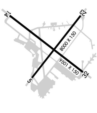
| Lat: N 4139.5 Long: W 07031.4 Elev: 130 Var: +15 Longest Runway: 9501 | ||
| Dept. ATIS: 120.47 Arr. ATIS: 120.47 Ground: 124.15 Tower: 128.42 | ||
| ||||||
| ||||||
|
| Rwy | Rwy | |||||||
| 8000x150 | 8000' | 8000x150 | 8000' | 109.55 - 233° | ||||
| 9501x150 | 9501' | 9501x150 | 9501' | 110.75 - 323° | ||||
| Runway ID | Single Wheel | Double Wheel | Double Tandem Wheel | Dual Double Wheel |
| 05/23 | N/A | N/A | N/A | N/A |
| 14/32 | N/A | N/A | N/A | N/A |
| These numbers are Advisory and are not limits. The Airport Manager should have more accurate Weight Limits | ||||
 Airport Diagram might not be current. | |
| Facility Name: | CAPE COD COAST GUARD AIR STATION |
| City Name: | FALMOUTH |
| County: | BARNSTABLE |
| State abbrev: | MA |
| State Name: | MASSACHUSETTS |
| Ownership: | CG |
| Use: | PRIVATE |
| Owner's Name: | US COAST GUARD |
| Address: | 3172 HERBERT RD |
| BUZZARDS BAY, MA 02542 | |
| Owner's Phone: | |
| Manager's Name: | TONY HYLINSKI |
| Address: | 3172 HERBERT RD, BUILDING 3172 |
| BUZZARDS BAY, MA 02542 | |
| Phone: | (508) 968-6674; ALTN FONE 508-968-6673. ANTHONY.P.HYLINSKI@USCG.MIL. |
| FAA Region: | NEW ENGLAND |
| FAA Field Office: | NONE |
| Date | Sunrise | Sunset |
|---|---|---|
| 09/24/21 Friday | 6:31 | 18:36 |
| 09/25/21 Saturday | 6:32 | 18:35 |
| 09/26/21 Sunday | 6:33 | 18:33 |
| 09/27/21 Monday | 6:34 | 18:31 |
| 09/28/21 Tuesday | 6:35 | 18:29 |
| 09/29/21 Wednesday | 6:36 | 18:28 |
| 09/30/21 Thursday | 6:38 | 18:26 |
| 10/01/21 Friday | 6:39 | 18:24 |
| 10/02/21 Saturday | 6:40 | 18:23 |
| 10/03/21 Sunday | 6:41 | 18:21 |
| 10/04/21 Monday | 6:42 | 18:19 |
| 10/05/21 Tuesday | 6:43 | 18:18 |
| 10/06/21 Wednesday | 6:44 | 18:16 |
| 10/07/21 Thursday | 6:45 | 18:14 |
| Airport Attendance Schedule | CONTINUOUS |
| Airport Status | OPERATIONAL (This Status can change at any time - please check NOTAMS) |
| Airport Lighting Schedule | DUSK-2300 |
| Airport Storage Available | Hanger |
| Extra Services Available | NONE |
| Wind Indicator | YES - (unlit) |
| Control Tower | YES |
| CTAF Frequency | |
| Unicom Frequency | |
| Rotating Beacon Color | CLEAR-GREEN (Light Land Airport); CLEAR SIDE IS SPLIT LIGHT..76... TURNED ON DAYLGT HRS WHEN A/D IS UNDER IFR CONDITIONS. |
| Segmented Circle | NO |
| Landing Fee | NO |
| Airport Inspected | No Inspection Data Available performed by the OWNER |
| Inspection Date | Unknown |
| Type of Fuel Available | 5 |
| Airframe Repair Service | NONE |
| Power Plant Repair Service | NONE |
| Latitude | N4139.5 |
| Longitude | W07031.4 (ESTIMATED) |
| Arpt Elevation | 130ft (SURVEYED) |
| Magnetic Variation | 15W |
| 0 miles | of FALMOUTH |
| Traffic Pattern Altitude | 970; ROTARY WING 970 FT AGL; FIXED WING CONVL 1470 FT AGL; JET OVHD 1970 FT AGL. |
| Sectional Chart | NEW YORK |
| Operations (Reported) | Yearly | Avg. Daily |
|---|---|---|
| General Aviation Transient | 0 | 0 |
| General Aviation Local | 0 | 0 |
| Air Taxi | 0 | 0 |
| Commerical | 0 | 0 |
| Commuter | 0 | 0 |
| Military | 32417 | 89 |
| Aircraft based on Field | |
|---|---|
| General Aviation Singles | 0 |
| General Aviation Multi | 0 |
| Jet Aircraft | 0 |
| General Aviation Helicopters | 0 |
| Military Aircraft | 0 |
| Gliders | 0 |
| Ultralights | 0 |
| FSS on field | NO |
| FSS tie-in | BRIDGEPORT |
| FSS Phone | 1-800-WX-BRIEF |
| Who issues Notams | FMH |
| Notam D service at airport | YES |
| ARTCC Name | BOSTON |
| Airport Certification | |
| Aircraft Rescue & Firefighting Index | None |
| Airport of Entry | No |
| Custom Landing Rights | No |
| Joint Civil/Military | No |
| Military Landing rights | No |
| RSTD: ANG RAMP UNUSBL. NO PPR FOR MIL/LAW ENFORCEMENT/MED FLT. CTC ARPT MGMT C508-968-6674 24 HR PRIOR IF PRKG/RON (EXCLD ACTIVE MEDEVAC). NO CIV LDG WO PPR FM ARPT MGMT. NO TSNT SVC INCL FUEL. |
| ARNG: PPR FOR ARNG RAMP, LTD FUEL AVBL: CTC OPS C508-968-5850. DSN 557-5850 FOR PPR. OPR 1200-2200Z++ MON-FRI, LTD SVC AVBL SAT-SUN WITH PRIOR COORDN. CTC BOSOX OPS 10 MIN PRIOR TO ARR ON 341.675, 138.5, 46.85. FLT BRIEFING RQRD PRIOR TO OPS IN R-4101. CTC OSA F/W DET C508-968-5291/5292 OR DSN 557-5291/5292 TO COORD JOSAC PAX ARR/DEP. |
| USCG: PPR FOR USCG RAMP, LTD SVC AVBL WITH PRIOR COORDN C508-968-6360/6361, DSN 557-6360/6361 OR C800-673-1056. ARR ACFT CTC USCG OPS (CAPEAIR) 345.0, 122.975 OR 164.55 15 MIN PRIOR TO ARR. |
| BRG STRENGTH RWY 05-23 & 14-32: ST175. |
| SEE FLIP AP/1 SUPPLEMENTARY ARPT |
| MISC: PPR IF ACN EXCEEDS PUBLD PCN. CTC ARPT MGMT C508-968-6674/6673 FOR APVL. |
| ANG APN IS THE ONLY APN CPBL OF ACPTG C5 AT GWT. |
| CAUTION: EXTSV BIRD ACT ALL QUADS. CK ATIS FOR UAS ACT IN CLASS D ASP. NON-STD OBST LGTD 368 FT TWRS 4 NM NNE OF ARPT. |
| NON-STD OBSTN LGTD 368 FT TWRS NE OF ARPT. |
| RWY 05/2 3 FIRST 350 FT RWY 05 CONC; REMAINING 7650 FT ASPH. |
| RWY 14/3 2 FIRST 2800 FT RWY 14 & FIRST 500 FT RWY 32 CONC; MID PORTION ASPH. |
Airport Communications & Frequencies:
| |||||||||||||||||||||||||||||
| Runway: 05 | Runway: 23 | ||
| Mag heading: | 54° | Mag heading: | 234° |
| Rwy Slope: | .19% Up | Rwy Slope: | -.19% Down |
| Approach: | Approach: | ILS/DME | |
| Pattern: | Left Traffic | Pattern: | Left Traffic |
| Markings: | PRECISION INSTRUMENT | Markings: | PRECISION INSTRUMENT |
| Marking Condition: | GOOD | Marking Condition: | GOOD |
| Arresting Dev: | Arresting Dev: | ||
| Lat & Long: | N4139.0 W07031.8 | Lat. & Long.: | N4140.0 W07030.7 |
| Elev: | 110.5 ft. MSL | Elev: | 125.5 ft. MSL |
| TCH: | 51 ft. AGL | TCH: | 53 ft. AGL |
| Visual Glide Path: | 3.00 degrees | Visual Glide Path: | 3.00 degrees |
| Displaced Threshold: | No | Displaced Threshold: | No |
| Touchdown Zone: | YES | Touchdown Zone: | YES |
| Touchdown Elev.: | 116.7 feet | Touchdown Elev.: | 125.5 feet |
| Visual Glide Slope: | 4-Light PAPI on LEFT side of Runway | Visual Glide Slope: | 4-Light PAPI on LEFT side of Runway |
| RVR Equipment: | ROLLOUT | RVR Equipment: | TOUCHDOWN |
| RVV Equipment: | NO | RVV Equipment: | NO |
| Approach Lights: | Approach Lights: | MALSR - 1,400 foot medium intensity approach lighting system with runway alignment indicator lights | |
| REIL: | YES | REIL: | NO |
| Centerline Lights: | NO | Centerline Lights: | NO |
| Touchdown lights: | NO | Touchdown lights: | NO |
| Runway Category: | Runway Category: | ||
| Declared Distances: | Declared Distances: |
| Runway: 14 | Runway: 32 | ||
| Mag heading: | 142° | Mag heading: | 322° |
| Rwy Slope: | -.21% Down | Rwy Slope: | .21% Up |
| Approach: | Approach: | ILS/DME | |
| Pattern: | Left Traffic | Pattern: | Left Traffic |
| Markings: | PRECISION INSTRUMENT | Markings: | PRECISION INSTRUMENT |
| Marking Condition: | GOOD | Marking Condition: | GOOD |
| Arresting Dev: | Arresting Dev: | ||
| Lat & Long: | N4140.0 W07032.3 | Lat. & Long.: | N4139.1 W07030.6 |
| Elev: | 130.2 ft. MSL | Elev: | 110.4 ft. MSL |
| TCH: | 47 ft. AGL | TCH: | 50 ft. AGL |
| Visual Glide Path: | 3.00 degrees | Visual Glide Path: | 3.00 degrees |
| Displaced Threshold: | No | Displaced Threshold: | No |
| Touchdown Zone: | YES | Touchdown Zone: | YES |
| Touchdown Elev.: | 130.2 feet | Touchdown Elev.: | 116.1 feet |
| Visual Glide Slope: | 4-Light PAPI on LEFT side of Runway | Visual Glide Slope: | 4-Light PAPI on LEFT side of Runway |
| RVR Equipment: | ROLLOUT | RVR Equipment: | TOUCHDOWN |
| RVV Equipment: | NO | RVV Equipment: | NO |
| Approach Lights: | Approach Lights: | MALSR - 1,400 foot medium intensity approach lighting system with runway alignment indicator lights | |
| REIL: | YES | REIL: | NO |
| Centerline Lights: | NO | Centerline Lights: | NO |
| Touchdown lights: | NO | Touchdown lights: | NO |
| Runway Category: | Runway Category: | ||
| Declared Distances: | Declared Distances: |
Thanks for using FltPlan.com
all rights reserved © 1999-2021 by Flight Plan LLC
