
| FALLON MUNI FALLON NV |
| |
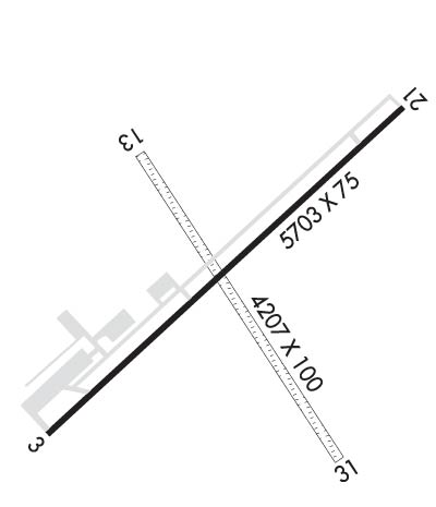
| Lat: N 3930.0 Long: W 11844.9 Elev: 3966 Var: -14 Longest Runway: 5705 | ||
| AWOS: 118.25 CTAF: 122.8 | ||
| ||||||||||||||||||||||||||||||||||||||||||||
| ||||||||||||||||||||||||||||||||||||||||||||
| ||||||||||||||||||||||||||||||||||||||||||||
| Rwy | Rwy | |||||||
| 5705x75 | 5603' | 5705x75 | 5705' | |||||
| 3581x60 | 3581' | 3581x60 | 3581' | |||||
| Runway ID | Single Wheel | Double Wheel | Double Tandem Wheel | Dual Double Wheel |
| 03/21 | 17,000 | N/A | N/A | N/A |
| 13/31 | N/A | N/A | N/A | N/A |
| These numbers are Advisory and are not limits. The Airport Manager should have more accurate Weight Limits | ||||
 Airport Diagram might not be current. | |
| Facility Name: | FALLON MUNI |
| City Name: | FALLON |
| County: | CHURCHILL |
| State abbrev: | NV |
| State Name: | NEVADA |
| Ownership: | PUBLICLY OWNED |
| Use: | OPEN TO THE PUBLIC |
| Owner's Name: | CITY OF FALLON |
| Address: | 55 WEST WILLIAMS AVE |
| FALLON, NV 89406 | |
| Owner's Phone: | 775-423-5107 |
| Manager's Name: | BRIAN BYRD; DEREK ZIMNEY. |
| Address: | 55 WEST WILLIAMS AVE |
| FALLON, NV 89406 | |
| Phone: | 775-217-5990 |
| FAA Region: | WESTERN-PACIFIC |
| FAA Field Office: | PHX |
| Date | Sunrise | Sunset |
|---|---|---|
| 09/24/21 Friday | 6:44 | 18:49 |
| 09/25/21 Saturday | 6:45 | 18:47 |
| 09/26/21 Sunday | 6:46 | 18:46 |
| 09/27/21 Monday | 6:47 | 18:44 |
| 09/28/21 Tuesday | 6:48 | 18:43 |
| 09/29/21 Wednesday | 6:49 | 18:41 |
| 09/30/21 Thursday | 6:50 | 18:39 |
| 10/01/21 Friday | 6:51 | 18:38 |
| 10/02/21 Saturday | 6:52 | 18:36 |
| 10/03/21 Sunday | 6:53 | 18:35 |
| 10/04/21 Monday | 6:54 | 18:33 |
| 10/05/21 Tuesday | 6:55 | 18:31 |
| 10/06/21 Wednesday | 6:56 | 18:30 |
| 10/07/21 Thursday | 6:57 | 18:28 |
| Airport Attendance Schedule | 7 Days A Week 0800-1700 |
| Airport Status | OPERATIONAL (This Status can change at any time - please check NOTAMS) |
| Airport Lighting Schedule | SS-SR |
| Airport Storage Available | Tie Downs, Hanger |
| Extra Services Available | Air Freight, Crop Dusting, Air Ambulance, Flight Instruction, Aircraft Rental |
| Wind Indicator | YES - (unlit) |
| Control Tower | NO |
| CTAF Frequency | 122.800 |
| Unicom Frequency | 122.800 |
| Rotating Beacon Color | CLEAR-GREEN (Light Land Airport) |
| Segmented Circle | YES |
| Landing Fee | NO |
| Airport Inspected | STATE - performed by STATE AERONAUTICAL PERSONNEL |
| Inspection Date | 03/22/2021 |
| Type of Fuel Available | Grade 100LL, JET A (freeze point -40C) |
| Airframe Repair Service | MAJOR |
| Power Plant Repair Service | MAJOR |
| Latitude | N3930.0 |
| Longitude | W11844.9 (ESTIMATED) |
| Arpt Elevation | 3966ft (SURVEYED) |
| Magnetic Variation | 14E |
| 2 miles NE | of FALLON |
| Traffic Pattern Altitude | 800 |
| Sectional Chart | SAN FRANCISCO |
| Operations (Reported) | Yearly | Avg. Daily |
|---|---|---|
| General Aviation Transient | 4200 | 12 |
| General Aviation Local | 3600 | 10 |
| Air Taxi | 720 | 2 |
| Commerical | 0 | 0 |
| Commuter | 0 | 0 |
| Military | 720 | 2 |
| Aircraft based on Field | |
|---|---|
| General Aviation Singles | 75 |
| General Aviation Multi | 2 |
| Jet Aircraft | 0 |
| General Aviation Helicopters | 2 |
| Military Aircraft | 0 |
| Gliders | 0 |
| Ultralights | 0 |
| FSS on field | NO |
| FSS tie-in | RENO |
| FSS Phone | 1-800-WX-BRIEF |
| Who issues Notams | RNO |
| Notam D service at airport | YES |
| ARTCC Name | OAKLAND |
| Airport Certification | |
| Aircraft Rescue & Firefighting Index | None |
| Airport of Entry | No |
| Custom Landing Rights | No |
| Joint Civil/Military | No |
| Military Landing rights | YES |
| NATIONAL PLAN OF INTEGRATED AIRPORT SYSTEMS (NPIAS) |
| GRANT AGREEMENTS UNDER FAAP/ADAP/AIP |
| CONVEYANCE UNDER SCETION 16, FEDERAL AIRPORT ACT OF 1946 OR SECTION 23, AIRPORT AND AIRWAY DEVELOPMENT ACT OF 1970 |
| ASSURANCES PURSUANT TO TITLE VI, CIVIL RIGHTS ACT OF 1964 |
| OVHD JET & ULTRALIGHT ACT INVOF ARPT. |
| FOR CD CTC OAKLAND ARTCC AT 510-745-3380. |
| LINE OF SIGHT BTN RWY 03 & 13 END BLOCKED; TMT ALL ARR & DEP. |
| (CONTACT PHONE NR) 775-426-9996 |
Airport Communications & Frequencies:
| |||||||||||||||||
| Runway: 03 | Runway: 21 | ||
| Mag heading: | 34° | Mag heading: | 214° |
| Rwy Slope: | -.06% Down | Rwy Slope: | .06% Up |
| Approach: | Approach: | ||
| Pattern: | Left Traffic | Pattern: | Left Traffic |
| Markings: | NONPRECISION INSTRUMENT | Markings: | NONPRECISION INSTRUMENT |
| Marking Condition: | GOOD | Marking Condition: | GOOD |
| Arresting Dev: | Arresting Dev: | ||
| Lat & Long: | N3929.7 W11845.4 | Lat. & Long.: | N3930.3 W11844.5 |
| Elev: | 3966.3 ft. MSL | Elev: | 3962.9 ft. MSL |
| TCH: | 40 ft. AGL | TCH: | 40 ft. AGL |
| Visual Glide Path: | 3.00 degrees | Visual Glide Path: | 3.00 degrees |
| Displaced Threshold: | 102 feet | Displaced Threshold: | No |
| Touchdown Zone: | YES | Touchdown Zone: | YES |
| Touchdown Elev.: | 3966.3 feet | Touchdown Elev.: | 3964.7 feet |
| Visual Glide Slope: | 2-Light PAPI on LEFT side of Runway | Visual Glide Slope: | 2-Light PAPI on LEFT side of Runway |
| RVR Equipment: | RVR Equipment: | ||
| RVV Equipment: | NO | RVV Equipment: | NO |
| Approach Lights: | Approach Lights: | ||
| REIL: | NO | REIL: | NO |
| Centerline Lights: | NO | Centerline Lights: | NO |
| Touchdown lights: | NO | Touchdown lights: | NO |
| Runway Category: | Runway with a Visual Approach | Runway Category: | Runway with a Visual Approach |
| Declared Distances: | TORA:5703' TODA:5703' | Declared Distances: | TORA:5703' TODA:5703' |
| Obstructions: | ROAD | Obstructions: | TREES |
| Marked: | NOT Marked/Lighted | Marked: | NOT Marked/Lighted |
| Clearance slope: | 19:1 | Clearance slope: | 19:1 |
| Obstruction height: | 14 feet AGL | Obstruction height: | 88 feet AGL |
| Dist. from runway: | 475 feet | Dist. from runway: | 1900 feet |
| Centerline offset: | Centerline offset: | 100 feet right of centerline | |
| Comments: | Comments: |
| Runway: 13 | Runway: 31 | ||
| Mag heading: | 132° | Mag heading: | 312° |
| Rwy Slope: | -.02% Down | Rwy Slope: | .02% Up |
| Approach: | Approach: | ||
| Pattern: | Left Traffic | Pattern: | Left Traffic |
| Markings: | Markings: | ||
| Marking Condition: | Marking Condition: | ||
| Arresting Dev: | Arresting Dev: | ||
| Lat & Long: | N3930.2 W11845.1 | Lat. & Long.: | N3929.7 W11844.7 |
| Elev: | 3962.0 ft. MSL | Elev: | 3961.4 ft. MSL |
| TCH: | TCH: | ||
| Visual Glide Path: | Visual Glide Path: | ||
| Displaced Threshold: | No | Displaced Threshold: | No |
| Touchdown Zone: | YES | Touchdown Zone: | YES |
| Touchdown Elev.: | 3964.6 feet | Touchdown Elev.: | 3964.6 feet |
| Visual Glide Slope: | Visual Glide Slope: | ||
| RVR Equipment: | RVR Equipment: | ||
| RVV Equipment: | NO | RVV Equipment: | NO |
| Approach Lights: | Approach Lights: | ||
| REIL: | NO | REIL: | NO |
| Centerline Lights: | NO | Centerline Lights: | NO |
| Touchdown lights: | NO | Touchdown lights: | NO |
| Runway Category: | Runway with a Visual Approach | Runway Category: | Runway with a Visual Approach |
| Declared Distances: | Declared Distances: | ||
| Obstructions: | TREES | Obstructions: | ROAD |
| Marked: | NOT Marked/Lighted | Marked: | NOT Marked/Lighted |
| Clearance slope: | 16:1; TREES ON CARSON RIVER. | Clearance slope: | 25:1 |
| Obstruction height: | 29 feet AGL; TREES ON CARSON RIVER. | Obstruction height: | 10 feet AGL |
| Dist. from runway: | 490 feet | Dist. from runway: | 250 feet |
| Centerline offset: | Centerline offset: | ||
| Comments: | Comments: |
Thanks for using FltPlan.com
all rights reserved © 1999-2021 by Flight Plan LLC
