
| FLAGSTAFF PULLIAM FLAGSTAFF AZ |
| |
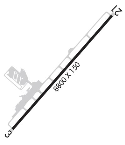
| Lat: N 3508.4 Long: W 11140.2 Elev: 7015 Var: -10 Longest Runway: 8800 | ||
| Dept. ATIS: 125.8 Arr. ATIS: 125.8 AWOS: 125.8 Ground: 121.9 Tower: 134.55 | ||
| ||||||||||||||||||||||||||||||||||||||||||||
| ||||||||||||||||||||||||||||||||||||||||||||
| ||||||||||||||||||||||||||||||||||||||||||||
| Rwy | Rwy | |||||||
| 8800x150 | 8800' | 8800x150 | 7000' | 110.50 - 214° | ||||
| Runway ID | Single Wheel | Double Wheel | Double Tandem Wheel | Dual Double Wheel |
| 03/21 | 30,000 | 95,000 | 140,000 | N/A |
| These numbers are Advisory and are not limits. The Airport Manager should have more accurate Weight Limits | ||||
 Airport Diagram might not be current. | |
| Facility Name: | FLAGSTAFF PULLIAM |
| City Name: | FLAGSTAFF |
| County: | COCONINO |
| State abbrev: | AZ |
| State Name: | ARIZONA |
| Ownership: | PUBLICLY OWNED |
| Use: | OPEN TO THE PUBLIC |
| Owner's Name: | CITY OF FLAGSTAFF |
| Address: | 211 W ASPEN AVE |
| FLAGSTAFF, AZ 86001 | |
| Owner's Phone: | 928-779-7685 |
| Manager's Name: | BARNEY HELMICK |
| Address: | 6200 S. PULLIAM DR, 204 |
| FLAGSTAFF, AZ 86005 | |
| Phone: | (928) 213-2933; EXT. 10 |
| FAA Region: | WESTERN-PACIFIC |
| FAA Field Office: | PHX |

| Date | Sunrise | Sunset |
|---|---|---|
| 09/24/21 Friday | 6:16 | 18:21 |
| 09/25/21 Saturday | 6:17 | 18:19 |
| 09/26/21 Sunday | 6:18 | 18:18 |
| 09/27/21 Monday | 6:18 | 18:17 |
| 09/28/21 Tuesday | 6:19 | 18:15 |
| 09/29/21 Wednesday | 6:20 | 18:14 |
| 09/30/21 Thursday | 6:21 | 18:12 |
| 10/01/21 Friday | 6:21 | 18:11 |
| 10/02/21 Saturday | 6:22 | 18:09 |
| 10/03/21 Sunday | 6:23 | 18:08 |
| 10/04/21 Monday | 6:24 | 18:07 |
| 10/05/21 Tuesday | 6:24 | 18:05 |
| 10/06/21 Wednesday | 6:25 | 18:04 |
| 10/07/21 Thursday | 6:26 | 18:02 |
| Airport Attendance Schedule | 7 Days A Week 0600-2300 |
| Airport Status | OPERATIONAL (This Status can change at any time - please check NOTAMS) |
| Airport Lighting Schedule | ATCT. WHEN ATCT CLSD ACTVT HIRL RY 03/21, MALSR RY 21 CTAF. PAPI RY 3/21 OPER CONTINUOUSLY. |
| Airport Storage Available | Tie Downs, Hanger |
| Extra Services Available | Air Freight, Air Ambulance, Charter, Flight Instruction, Aircraft Rental, Aircraft Sales |
| Wind Indicator | YES - (lighted) |
| Control Tower | YES |
| CTAF Frequency | 134.550 |
| Unicom Frequency | 122.950 |
| Rotating Beacon Color | CLEAR-GREEN (Light Land Airport) |
| Segmented Circle | NO |
| Landing Fee | NO |
| Airport Inspected | FEDERAL - performed by FAA AIRPORTS FIELD PERSONNEL |
| Inspection Date | 06/11/2019 |
| Type of Fuel Available | Grade 100LL, JET A (freeze point -40C); -10FULL AND SELF-SERVICE FUEL AVAILABLE 24 HRS. |
| Airframe Repair Service | MAJOR |
| Power Plant Repair Service | MAJOR |
| Latitude | N3508.4 |
| Longitude | W11140.2 (ESTIMATED) |
| Arpt Elevation | 7014ft (SURVEYED) |
| Magnetic Variation | 10E |
| 4 miles S | of FLAGSTAFF |
| Traffic Pattern Altitude | TPA: CONVENTIONAL ACFT 989 FT AGL, HELICOPTER 489 FT AGL, HIGH PERFORMANCE 1489 FT AGL. |
| Sectional Chart | PHOENIX |
| Operations (Reported) | Yearly | Avg. Daily |
|---|---|---|
| General Aviation Transient | 22352 | 61 |
| General Aviation Local | 9580 | 26 |
| Air Taxi | 10778 | 30 |
| Commerical | 1157 | 3 |
| Commuter | 0 | 0 |
| Military | 1042 | 3 |
| Aircraft based on Field | |
|---|---|
| General Aviation Singles | 101 |
| General Aviation Multi | 6 |
| Jet Aircraft | 2 |
| General Aviation Helicopters | 3 |
| Military Aircraft | 0 |
| Gliders | 3 |
| Ultralights | 0 |
| FSS on field | NO |
| FSS tie-in | PRESCOTT |
| FSS Phone | 1-800-WX-BRIEF |
| Who issues Notams | FLG |
| Notam D service at airport | YES |
| ARTCC Name | ALBUQUERQUE |
| Airport Certification | AIRPORT RECEIVING SCHEDULED AIR CARRIER SERVICE FROM CARRIERS CERTIFICATED BY THE CIVIL AERONAUTICS BOARD |
| Aircraft Rescue & Firefighting Index | AIRPORT HAS A CERTIFICATE UNDER CFR PART 139 |
| Airport of Entry | No |
| Custom Landing Rights | No |
| Joint Civil/Military | No |
| Military Landing rights | YES |
| NATIONAL PLAN OF INTEGRATED AIRPORT SYSTEMS (NPIAS) |
| GRANT AGREEMENTS UNDER FAAP/ADAP/AIP |
| CONVEYANCE UNDER SCETION 16, FEDERAL AIRPORT ACT OF 1946 OR SECTION 23, AIRPORT AND AIRWAY DEVELOPMENT ACT OF 1970 |
| ASSURANCES PURSUANT TO TITLE VI, CIVIL RIGHTS ACT OF 1964 |
| SNOW RVML EQUIP MAY BE ON RWY. EQUIP HAS 2-WAY RDO & MONITORS FREQ 134.55 WHEN ATCT CLSD. ARPT MAY BE CLSD DURING SNOW REMOVAL. FOR CURRENT SNOW RVML EQUIP ACTIVITY CONTACT 134.55. |
| RWY 03/21 WINDSHEAR & TURBULENCE AT BOTH ENDS OF RWY WHEN SFC WINDS EXCEED 10 KNOTS. |
| (A88) TOLL TO PRESCOTT. |
| (A89) USE FOR FSS ALSO. |
| ILS UNMON WHEN ATCT CLSD. |
| FOR CD WHEN ATCT CLSD, CTC PHOENIX APCH AT 602-306-2565. |
| NOISE ABATEMENT PROCEDURE: AVOID OVERFLIGHT OF VILLAGE 3 MILES SOUTH. |
| CALM WIND CONDS USE RWY 21. |
Airport Communications & Frequencies:
| |||||||||||||||||||||||||||
| Runway: 03 | Runway: 21 | ||
| Mag heading: | 31° | Mag heading: | 211° |
| Rwy Slope: | -.20% Down | Rwy Slope: | .20% Up |
| Approach: | Approach: | LOC/GS | |
| Pattern: | Left Traffic | Pattern: | Left Traffic |
| Markings: | NONPRECISION INSTRUMENT | Markings: | PRECISION INSTRUMENT |
| Marking Condition: | GOOD | Marking Condition: | GOOD |
| Arresting Dev: | Arresting Dev: | ||
| Lat & Long: | N3507.9 W11140.7 | Lat. & Long.: | N3509.0 W11139.6 |
| Elev: | 7014.4 ft. MSL | Elev: | 6996.4 ft. MSL |
| TCH: | 52 ft. AGL | TCH: | 51 ft. AGL |
| Visual Glide Path: | 3.00 degrees | Visual Glide Path: | 3.00 degrees |
| Displaced Threshold: | No | Displaced Threshold: | 1800 feet |
| Touchdown Zone: | YES | Touchdown Zone: | YES |
| Touchdown Elev.: | 7014.7 feet | Touchdown Elev.: | 7003.8 feet |
| Visual Glide Slope: | 4-Light PAPI on LEFT side of Runway | Visual Glide Slope: | 4-Light PAPI on LEFT side of Runway |
| RVR Equipment: | RVR Equipment: | ||
| RVV Equipment: | NO | RVV Equipment: | NO |
| Approach Lights: | Approach Lights: | MALSR - 1,400 foot medium intensity approach lighting system with runway alignment indicator lights | |
| REIL: | NO | REIL: | NO |
| Centerline Lights: | NO | Centerline Lights: | NO |
| Touchdown lights: | NO | Touchdown lights: | NO |
| Runway Category: | Runway with a Non-precision Approach having visibility minimums greater than 3/4 mile | Runway Category: | Precision Instrument Runway |
| Declared Distances: | TORA:8800' TODA:8800' ASDA:8800' LDA:8800' | Declared Distances: | TORA:8800' TODA:8800' ASDA:8800' LDA:7000' |
Thanks for using FltPlan.com
all rights reserved © 1999-2021 by Flight Plan LLC