
| FOND DU LAC COUNTY FOND DU LAC WI |
| |
| Lat: N 4346.3 Long: W 08829.3 Elev: 809 Var: +04 Longest Runway: 5941 | ||
| AWOS: 134.0 CTAF: 123.05 | ||
| ||||||||||||||||||||||||||||||||||||||||||||
| ||||||||||||||||||||||||||||||||||||||||||||
| ||||||||||||||||||||||||||||||||||||||||||||
| Rwy | Rwy | |||||||
| 3604x75 | 3604' | 3604x75 | 3604' | |||||
| 5941x100 | 5941' | 5941x100 | 5941' | 108.30 - 001° | ||||
| Runway ID | Single Wheel | Double Wheel | Double Tandem Wheel | Dual Double Wheel |
| 09/27 | 22,000 | N/A | N/A | N/A |
| 18/36 | N/A | 60,000 | N/A | N/A |
| These numbers are Advisory and are not limits. The Airport Manager should have more accurate Weight Limits | ||||
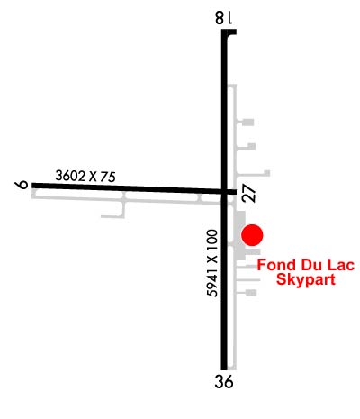 Airport Diagram might not be current. | |
| Facility Name: | FOND DU LAC COUNTY |
| City Name: | FOND DU LAC |
| County: | FOND DU LAC |
| State abbrev: | WI |
| State Name: | WISCONSIN |
| Ownership: | PUBLICLY OWNED |
| Use: | OPEN TO THE PUBLIC |
| Owner's Name: | FOND DU LAC COUNTY |
| Address: | 160 S MACY |
| FOND DU LAC, WI 54935 | |
| Owner's Phone: | 920-922-4162 |
| Manager's Name: | BRYAN LINGER |
| Address: | 260 S. ROLLING MEADOWS DRIVE |
| FOND DU LAC, WI 54937 | |
| Phone: | 920-926-0653 |
| FAA Region: | GREAT LAKES |
| FAA Field Office: | CHI |

| Date | Sunrise | Sunset |
|---|---|---|
| 06/08/26 Monday | 5:12 | 20:34 |
| 06/09/26 Tuesday | 5:12 | 20:35 |
| 06/10/26 Wednesday | 5:12 | 20:35 |
| 06/11/26 Thursday | 5:12 | 20:36 |
| 06/12/26 Friday | 5:11 | 20:36 |
| 06/13/26 Saturday | 5:11 | 20:37 |
| 06/14/26 Sunday | 5:11 | 20:37 |
| 06/15/26 Monday | 5:11 | 20:38 |
| 06/16/26 Tuesday | 5:11 | 20:38 |
| 06/17/26 Wednesday | 5:11 | 20:38 |
| 06/18/26 Thursday | 5:11 | 20:39 |
| 06/19/26 Friday | 5:12 | 20:39 |
| 06/20/26 Saturday | 5:12 | 20:39 |
| 06/21/26 Sunday | 5:12 | 20:39 |
| Airport Attendance Schedule | 7 Days A Week 0800-1800; FOR ATTENDANT AFT HRS CALL 920-922-6000. |
| Airport Status | OPERATIONAL (This Status can change at any time - please check NOTAMS) |
| Airport Lighting Schedule | HIRL RWY 18/36 PRESET TO LOW SS-SR; TO INCR INTST AND ACTVT MALSR RWY 36; REIL RWY 18; PAPI RWY 18 & 36; MIRL RWY 09/27 - CTAF. |
| Airport Storage Available | Tie Downs, Hanger |
| Extra Services Available | Charter, Flight Instruction, Aircraft Rental, Aircraft Sales |
| Wind Indicator | YES - (lighted) |
| Control Tower | NO |
| CTAF Frequency | 123.050 |
| Unicom Frequency | 123.050 |
| Rotating Beacon Color | WG |
| Segmented Circle | YES |
| Landing Fee | NO |
| Airport Inspected | STATE - performed by STATE AERONAUTICAL PERSONNEL |
| Inspection Date | 09/27/2023 |
| Type of Fuel Available | Grade 100LL, JET A (freeze point -40C) |
| Airframe Repair Service | MAJOR |
| Power Plant Repair Service | MAJOR |
| Latitude | N4346.3 |
| Longitude | W08829.3 (ESTIMATED) |
| Arpt Elevation | 808ft (SURVEYED) |
| Magnetic Variation | 04W |
| 1 miles W | of FOND DU LAC |
| Traffic Pattern Altitude | |
| Sectional Chart | CHICAGO |
| Operations (Reported) | Yearly | Avg. Daily |
|---|---|---|
| General Aviation Transient | 0 | 0 |
| General Aviation Local | 0 | 0 |
| Air Taxi | 0 | 0 |
| Commerical | 0 | 0 |
| Commuter | 0 | 0 |
| Military | 0 | 0 |
| Aircraft based on Field | |
|---|---|
| General Aviation Singles | 0 |
| General Aviation Multi | 0 |
| Jet Aircraft | 0 |
| General Aviation Helicopters | 0 |
| Military Aircraft | 0 |
| Gliders | 0 |
| Ultralights | 0 |
| FSS on field | NO |
| FSS tie-in | GREEN BAY |
| FSS Phone | 1-800-WX-BRIEF |
| Who issues Notams | FLD |
| Notam D service at airport | YES |
| ARTCC Name | CHICAGO |
| Airport Certification | |
| Aircraft Rescue & Firefighting Index | None |
| Airport of Entry | No |
| Custom Landing Rights | No |
| Joint Civil/Military | No |
| Military Landing rights | YES |
| NATIONAL PLAN OF INTEGRATED AIRPORT SYSTEMS (NPIAS) |
| GRANT AGREEMENTS UNDER FAAP/ADAP/AIP |
| ASSURANCES PURSUANT TO TITLE VI, CIVIL RIGHTS ACT OF 1964 |
| FOR CD IF UNA TO CTC ON FSS FREQ, CTC CHICAGO ARTCC AT 630-906-8921. |
Airport Communications & Frequencies:
| ||||||||||||||
| Runway: 09 | Runway: 27 | ||
| Mag heading: | 96° | Mag heading: | 276° |
| Rwy Slope: | -.57% Down | Rwy Slope: | .57% Up |
| Approach: | Approach: | ||
| Pattern: | Right Traffic | Pattern: | Left Traffic |
| Markings: | NONPRECISION INSTRUMENT | Markings: | NONPRECISION INSTRUMENT |
| Marking Condition: | FAIR | Marking Condition: | FAIR |
| Arresting Dev: | Arresting Dev: | ||
| Lat & Long: | N4346.3 W08829.9 | Lat. & Long.: | N4346.3 W08829.1 |
| Elev: | 808.6 ft. MSL | Elev: | 788.1 ft. MSL |
| TCH: | TCH: | ||
| Visual Glide Path: | Visual Glide Path: | ||
| Displaced Threshold: | No | Displaced Threshold: | No |
| Touchdown Zone: | YES | Touchdown Zone: | YES |
| Touchdown Elev.: | 808.6 feet | Touchdown Elev.: | 803.2 feet |
| Visual Glide Slope: | Visual Glide Slope: | ||
| RVR Equipment: | RVR Equipment: | ||
| RVV Equipment: | NO | RVV Equipment: | NO |
| Approach Lights: | Approach Lights: | ||
| REIL: | NO | REIL: | NO |
| Centerline Lights: | NO | Centerline Lights: | NO |
| Touchdown lights: | NO | Touchdown lights: | NO |
| Runway Category: | Runway with a Visual Approach | Runway Category: | Runway with a Visual Approach |
| Declared Distances: | Declared Distances: |
| Runway: 18 | Runway: 36 | ||
| Mag heading: | 184° | Mag heading: | 4° |
| Rwy Slope: | .20% Up | Rwy Slope: | -.20% Down |
| Approach: | Approach: | LOC/DME | |
| Pattern: | Right Traffic | Pattern: | Left Traffic |
| Markings: | NONPRECISION INSTRUMENT | Markings: | NONPRECISION INSTRUMENT |
| Marking Condition: | FAIR | Marking Condition: | FAIR |
| Arresting Dev: | Arresting Dev: | ||
| Lat & Long: | N4346.7 W08829.2 | Lat. & Long.: | N4345.8 W08829.2 |
| Elev: | 782.5 ft. MSL | Elev: | 794.2 ft. MSL |
| TCH: | 35 ft. AGL | TCH: | 35 ft. AGL |
| Visual Glide Path: | 3.00 degrees | Visual Glide Path: | 3.00 degrees |
| Displaced Threshold: | No | Displaced Threshold: | No |
| Touchdown Zone: | YES | Touchdown Zone: | YES |
| Touchdown Elev.: | 790.5 feet | Touchdown Elev.: | 795.0 feet |
| Visual Glide Slope: | 4-Light PAPI on LEFT side of Runway | Visual Glide Slope: | 4-Light PAPI on LEFT side of Runway |
| RVR Equipment: | RVR Equipment: | ||
| RVV Equipment: | NO | RVV Equipment: | NO |
| Approach Lights: | Approach Lights: | MALSR - 1,400 foot medium intensity approach lighting system with runway alignment indicator lights | |
| REIL: | YES | REIL: | NO |
| Centerline Lights: | NO | Centerline Lights: | NO |
| Touchdown lights: | NO | Touchdown lights: | NO |
| Runway Category: | Runway with a Non-precision Approach having visibility minimums greater than 3/4 mile | Runway Category: | D |
| Declared Distances: | Declared Distances: | ||
| Obstructions: | BLDG | Obstructions: | TREE |
| Marked: | NOT Marked/Lighted | Marked: | NOT Marked/Lighted |
| Clearance slope: | CTLNG OBSTN EXCEEDS A 45 DEG SLP. | Clearance slope: | 13:1 |
| Obstruction height: | 7 feet AGL | Obstruction height: | 17 feet AGL |
| Dist. from runway: | 200 feet | Dist. from runway: | 425 feet |
| Centerline offset: | 440 left of centerline | Centerline offset: | 480 feet left of centerline |
| Comments: | 7 FT BLDG 180 FT FM RWY END, 440 L. | Comments: |
Thanks for using FltPlan.com
all rights reserved © 1999-2026 by Flight Plan LLC