
| FRANKFORT DOW MEMORIAL FRANKFORT MI |
| |
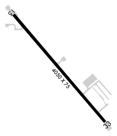
| Lat: N 4437.5 Long: W 08612.1 Elev: 633 Var: +04 Longest Runway: 4050 | ||
| AWOS: 118.32 CTAF: 123.05 | ||
| ||||||||||||||||||||||||||||||||||||||||||||
| ||||||||||||||||||||||||||||||||||||||||||||
| ||||||||||||||||||||||||||||||||||||||||||||
| Rwy | Rwy | |||||||
| 4050x75 | 2956' | 4050x75 | 3939' | |||||
| Runway ID | Single Wheel | Double Wheel | Double Tandem Wheel | Dual Double Wheel |
| 15/33 | 25,000 | N/A | N/A | N/A |
| These numbers are Advisory and are not limits. The Airport Manager should have more accurate Weight Limits | ||||
 Airport Diagram might not be current. | |
| Facility Name: | FRANKFORT DOW MEML FLD |
| City Name: | FRANKFORT |
| County: | BENZIE |
| State abbrev: | MI |
| State Name: | MICHIGAN |
| Ownership: | PUBLICLY OWNED |
| Use: | OPEN TO THE PUBLIC |
| Owner's Name: | FRANKFORT CITY-CO ARPT AUTH |
| Address: | 650 AIRPORT RD |
| FRANKFORT, MI 49635-9785 | |
| Owner's Phone: | 231-352-9118 |
| Manager's Name: | BROOKE TRENTHAM POPP |
| Address: | 650 AIRPORT RD |
| FRANKFORT, MI 49635-9785 | |
| Phone: | 231-352-9118; CELL 231-383-2126. |
| FAA Region: | GREAT LAKES |
| FAA Field Office: | DET |

| Date | Sunrise | Sunset |
|---|---|---|
| 06/16/26 Tuesday | 5:59 | 21:32 |
| 06/17/26 Wednesday | 5:59 | 21:33 |
| 06/18/26 Thursday | 5:59 | 21:33 |
| 06/19/26 Friday | 5:59 | 21:33 |
| 06/20/26 Saturday | 5:59 | 21:33 |
| 06/21/26 Sunday | 5:59 | 21:34 |
| 06/22/26 Monday | 6:00 | 21:34 |
| 06/23/26 Tuesday | 6:00 | 21:34 |
| 06/24/26 Wednesday | 6:00 | 21:34 |
| 06/25/26 Thursday | 6:01 | 21:34 |
| 06/26/26 Friday | 6:01 | 21:34 |
| 06/27/26 Saturday | 6:01 | 21:34 |
| 06/28/26 Sunday | 6:02 | 21:34 |
| 06/29/26 Monday | 6:02 | 21:34 |
| Airport Attendance Schedule | IRREGULAR; FOR ON CALL ATTENDANT CALL AMGR. |
| Airport Status | OPERATIONAL (This Status can change at any time - please check NOTAMS) |
| Airport Lighting Schedule | ACTVT REIL RWY 33; PAPI RWY 33; MIRL RWY 15/33 - CTAF (3 MIKE CLICKS TURNS OFF). |
| Airport Storage Available | Tie Downs |
| Extra Services Available | NONE |
| Wind Indicator | YES - (lighted) |
| Control Tower | NO |
| CTAF Frequency | 123.050 |
| Unicom Frequency | 123.050 |
| Rotating Beacon Color | WG; ARPT BCN LOCATED ON HILL 1.25 MILES NW OF ARPT. |
| Segmented Circle | YES |
| Landing Fee | YES; RAMP FEE DTRMD BY WT. |
| Airport Inspected | STATE - performed by STATE AERONAUTICAL PERSONNEL |
| Inspection Date | 06/12/2024 |
| Type of Fuel Available | Grade 100LL; -10AVBL SELF SVC VIA CREDIT CARD. |
| Airframe Repair Service | None |
| Power Plant Repair Service | None |
| Latitude | N4437.5 |
| Longitude | W08612.1 (ESTIMATED) |
| Arpt Elevation | 633ft (SURVEYED) |
| Magnetic Variation | 04W |
| 2 miles SE | of FRANKFORT |
| Traffic Pattern Altitude | |
| Sectional Chart | GREEN BAY |
| Operations (Reported) | Yearly | Avg. Daily |
|---|---|---|
| General Aviation Transient | 0 | 0 |
| General Aviation Local | 0 | 0 |
| Air Taxi | 0 | 0 |
| Commerical | 0 | 0 |
| Commuter | 0 | 0 |
| Military | 0 | 0 |
| Aircraft based on Field | |
|---|---|
| General Aviation Singles | 0 |
| General Aviation Multi | 0 |
| Jet Aircraft | 0 |
| General Aviation Helicopters | 0 |
| Military Aircraft | 0 |
| Gliders | 0 |
| Ultralights | 0 |
| FSS on field | NO |
| FSS tie-in | LANSING |
| FSS Phone | 1-800-WX-BRIEF |
| Who issues Notams | FKS |
| Notam D service at airport | YES |
| ARTCC Name | MINNEAPOLIS |
| Airport Certification | |
| Aircraft Rescue & Firefighting Index | None |
| Airport of Entry | No |
| Custom Landing Rights | No |
| Joint Civil/Military | No |
| Military Landing rights | YES |
| NATIONAL PLAN OF INTEGRATED AIRPORT SYSTEMS (NPIAS) |
| GRANT AGREEMENT HAS EXPIRED; HOWEVER, AGREEMENT REMAINS IN EFFECT FOR THIS FACILITY AS LONG AS IT IS PUBLIC USE. |
| ADMIN BLDG ACES: PRESS 5-3-2-1. |
| HANG GLIDER ACTIVITY ALONG LAKE MICHIGAN LAKESHORE. |
| FOR CD CTC MINNEAPOLIS ARTCC AT 651-463-5588. |
| DEER & BIRDS ON & INVOF ARPT. |
Airport Communications & Frequencies:
| |||||||||
| Runway: 15 | Runway: 33 | ||
| Mag heading: | 143° | Mag heading: | 323° |
| Rwy Slope: | -.67% Down | Rwy Slope: | .67% Up |
| Approach: | Approach: | ||
| Pattern: | Left Traffic | Pattern: | Left Traffic |
| Markings: | NONPRECISION INSTRUMENT | Markings: | NONPRECISION INSTRUMENT |
| Marking Condition: | GOOD | Marking Condition: | GOOD |
| Arresting Dev: | Arresting Dev: | ||
| Lat & Long: | N4437.8 W08612.4 | Lat. & Long.: | N4437.3 W08611.7 |
| Elev: | 633.2 ft. MSL | Elev: | 606.0 ft. MSL |
| TCH: | TCH: | 35 ft. AGL | |
| Visual Glide Path: | Visual Glide Path: | 3.00 degrees | |
| Displaced Threshold: | 1094 feet | Displaced Threshold: | 111 feet |
| Touchdown Zone: | YES | Touchdown Zone: | YES |
| Touchdown Elev.: | 623.0 feet | Touchdown Elev.: | 624.0 feet |
| Visual Glide Slope: | Visual Glide Slope: | 2-Light PAPI on RIGHT side of Runway | |
| RVR Equipment: | RVR Equipment: | ||
| RVV Equipment: | NO | RVV Equipment: | NO |
| Approach Lights: | Approach Lights: | ||
| REIL: | NO | REIL: | YES |
| Centerline Lights: | NO | Centerline Lights: | NO |
| Touchdown lights: | NO | Touchdown lights: | NO |
| Runway Category: | Runway with a Non-precision Approach | Runway Category: | Runway with a Non-precision Approach |
| Declared Distances: | Declared Distances: | ||
| Obstructions: | ROAD | Obstructions: | TREE |
| Marked: | NOT Marked/Lighted | Marked: | NOT Marked/Lighted |
| Clearance slope: | APCH RATIO 17:1 TO DTHR. | Clearance slope: | 12:1; APCH RATIO 18:1 TO DTHR. |
| Obstruction height: | 20 feet AGL | Obstruction height: | 54 feet AGL |
| Dist. from runway: | 201 feet | Dist. from runway: | 896 feet |
| Centerline offset: | 230 left of centerline | Centerline offset: | 285 feet right of centerline |
| Comments: | +20 FT ROAD. | Comments: |
Thanks for using FltPlan.com
all rights reserved © 1999-2026 by Flight Plan LLC