
| FRANKLIN MUNI-JOHN BEVERLY ROS FRANKLIN VA |
| |
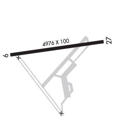
| Lat: N 3642.0 Long: W 07654.1 Elev: 40 Var: +09 Longest Runway: 4977 | ||
| AWOS: 124.67 CTAF: 122.8 | ||
| ||||||
| ||||||
|
| Rwy | Rwy | |||||||
| 4977x100 | 4977' | 4977x100 | 4977' | |||||
| Runway ID | Single Wheel | Double Wheel | Double Tandem Wheel | Dual Double Wheel |
| 09/27 | N/A | N/A | N/A | N/A |
| These numbers are Advisory and are not limits. The Airport Manager should have more accurate Weight Limits | ||||
 Airport Diagram might not be current. | |
| Facility Name: | FRANKLIN RGNL |
| City Name: | FRANKLIN |
| County: | ISLE OF WIGHT |
| State abbrev: | VA |
| State Name: | VIRGINIA |
| Ownership: | PUBLICLY OWNED |
| Use: | OPEN TO THE PUBLIC |
| Owner's Name: | CITY OF FRANKLIN |
| Address: | P O BOX 179 |
| FRANKLIN, VA 23851 | |
| Owner's Phone: | 757-562-8561 |
| Manager's Name: | TREVELYN LINTON |
| Address: | 32470 JOHN BEVERLY ROSE DR |
| FRANKLIN, VA 23851 | |
| Phone: | 757-562-8764; CTC 757-562-8575 FOR AFTER HOUR EMERGENCIES. |
| FAA Region: | EASTERN |
| FAA Field Office: | DCA |
| Date | Sunrise | Sunset |
|---|---|---|
| 09/24/21 Friday | 6:57 | 19:02 |
| 09/25/21 Saturday | 6:58 | 19:00 |
| 09/26/21 Sunday | 6:58 | 18:59 |
| 09/27/21 Monday | 6:59 | 18:57 |
| 09/28/21 Tuesday | 7:00 | 18:56 |
| 09/29/21 Wednesday | 7:01 | 18:54 |
| 09/30/21 Thursday | 7:02 | 18:53 |
| 10/01/21 Friday | 7:03 | 18:51 |
| 10/02/21 Saturday | 7:03 | 18:50 |
| 10/03/21 Sunday | 7:04 | 18:48 |
| 10/04/21 Monday | 7:05 | 18:47 |
| 10/05/21 Tuesday | 7:06 | 18:46 |
| 10/06/21 Wednesday | 7:07 | 18:44 |
| 10/07/21 Thursday | 7:08 | 18:43 |
| Airport Attendance Schedule | 7 Days A Week 0800-1700 |
| Airport Status | OPERATIONAL (This Status can change at any time - please check NOTAMS) |
| Airport Lighting Schedule | ACTVT MIRL 09/27 - CTAF. |
| Airport Storage Available | Tie Downs |
| Extra Services Available | Crop Dusting, Aircraft Rental |
| Wind Indicator | YES - (lighted) |
| Control Tower | NO |
| CTAF Frequency | 122.800 |
| Unicom Frequency | 122.800 |
| Rotating Beacon Color | CLEAR-GREEN (Light Land Airport) |
| Segmented Circle | NO |
| Landing Fee | NO |
| Airport Inspected | STATE - performed by STATE AERONAUTICAL PERSONNEL |
| Inspection Date | 06/04/2019 |
| Type of Fuel Available | Grade 100LL, JET A (freeze point -40C) |
| Airframe Repair Service | MAJOR |
| Power Plant Repair Service | MAJOR |
| Latitude | N3642.0 |
| Longitude | W07654.1 (ESTIMATED) |
| Arpt Elevation | 40ft (SURVEYED) |
| Magnetic Variation | 09W |
| 2 miles NE | of FRANKLIN |
| Traffic Pattern Altitude | |
| Sectional Chart | WASHINGTON |
| Operations (Reported) | Yearly | Avg. Daily |
|---|---|---|
| General Aviation Transient | 1629 | 4 |
| General Aviation Local | 1267 | 3 |
| Air Taxi | 37 | 0 |
| Commerical | 0 | 0 |
| Commuter | 0 | 0 |
| Military | 1172 | 3 |
| Aircraft based on Field | |
|---|---|
| General Aviation Singles | 15 |
| General Aviation Multi | 0 |
| Jet Aircraft | 0 |
| General Aviation Helicopters | 2 |
| Military Aircraft | 0 |
| Gliders | 0 |
| Ultralights | 0 |
| FSS on field | NO |
| FSS tie-in | LEESBURG |
| FSS Phone | 1-800-WX-BRIEF |
| Who issues Notams | FKN |
| Notam D service at airport | YES |
| ARTCC Name | WASHINGTON |
| Airport Certification | |
| Aircraft Rescue & Firefighting Index | None |
| Airport of Entry | No |
| Custom Landing Rights | No |
| Joint Civil/Military | No |
| Military Landing rights | YES |
| NATIONAL PLAN OF INTEGRATED AIRPORT SYSTEMS (NPIAS) |
| GRANT AGREEMENTS UNDER FAAP/ADAP/AIP |
| SURPLUS PROPERTY AGREEMENT UNDER REGULATION 16-WAA |
| ASSURANCES PURSUANT TO TITLE VI, CIVIL RIGHTS ACT OF 1964 |
| AGREEMENT UNDER DLAND OR DCLA HAS EXPIRED. |
| DEER ON AND INVOF ARPT |
| PSBL TFC FM THE SOUTHAMPTON MEMORIAL HELIPAD 2 NM W OF ARPT. |
| DRAINAGE DITCHES NEXT TO RY & TWYS. |
| FOR CD CTC NORFOLK APCH AT 757-464-0757. |
| ARPT FBO CLSD SAT AND SUN |
Airport Communications & Frequencies:
| ||||||||||||||
| Runway: 09 | Runway: 27 | ||
| Mag heading: | 90° | Mag heading: | 270° |
| Rwy Slope: | .14% Up | Rwy Slope: | -.14% Down |
| Approach: | Approach: | ||
| Pattern: | Left Traffic | Pattern: | Left Traffic |
| Markings: | NONPRECISION INSTRUMENT | Markings: | NONPRECISION INSTRUMENT |
| Marking Condition: | FAIR | Marking Condition: | FAIR |
| Arresting Dev: | Arresting Dev: | ||
| Lat & Long: | N3642.0 W07654.6 | Lat. & Long.: | N3642.1 W07653.6 |
| Elev: | 33.3 ft. MSL | Elev: | 40.3 ft. MSL |
| TCH: | 40 ft. AGL | TCH: | 40 ft. AGL |
| Visual Glide Path: | 3.00 degrees | Visual Glide Path: | 3.00 degrees |
| Displaced Threshold: | No | Displaced Threshold: | No |
| Touchdown Zone: | YES | Touchdown Zone: | YES |
| Touchdown Elev.: | 35.3 feet | Touchdown Elev.: | 40.3 feet |
| Visual Glide Slope: | 2-Light PAPI on LEFT side of Runway | Visual Glide Slope: | 2-Light PAPI on LEFT side of Runway; RY 27 PAPI UNUSABLE BYD 1 NM FM THLD. |
| RVR Equipment: | RVR Equipment: | ||
| RVV Equipment: | NO | RVV Equipment: | NO |
| Approach Lights: | Approach Lights: | ||
| REIL: | NO | REIL: | NO |
| Centerline Lights: | NO | Centerline Lights: | NO |
| Touchdown lights: | NO | Touchdown lights: | NO |
| Runway Category: | Runway with a Non-precision Approach having visibility minimums greater than 3/4 mile | Runway Category: | Runway with a Non-precision Approach having visibility minimums greater than 3/4 mile |
| Declared Distances: | Declared Distances: | ||
| Obstructions: | BRUSH | Obstructions: | TREE |
| Marked: | NOT Marked/Lighted | Marked: | NOT Marked/Lighted |
| Clearance slope: | 4:1 | Clearance slope: | 18:1 |
| Obstruction height: | 26 feet AGL | Obstruction height: | 85 feet AGL |
| Dist. from runway: | 307 feet | Dist. from runway: | 1802 feet |
| Centerline offset: | 264 right of centerline | Centerline offset: | 474 feet right of centerline |
| Comments: | Comments: | 4 FT HIGH FENCE 139 FT FM RY END, 242 FT LEFT ON APCH. |
Thanks for using FltPlan.com
all rights reserved © 1999-2021 by Flight Plan LLC
