
| FITCHBURG MUNI FITCHBURG MA |
| |
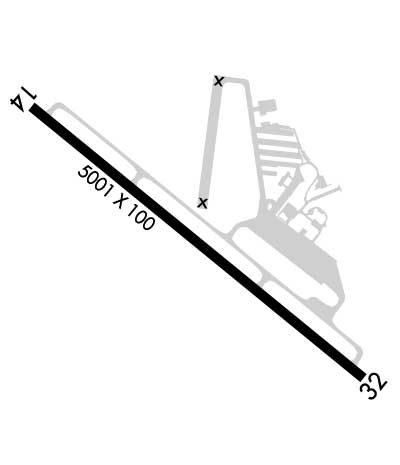
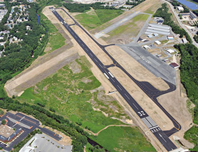
| Lat: N 4233.2 Long: W 07145.6 Elev: 345 Var: +15 Longest Runway: 5001 | ||
| Clr Del: 603-594-5552 AWOS: 135.17 CTAF: 122.7 | ||
| ||||||||||||||||||||||||||||||||||||||||||||
| ||||||||||||||||||||||||||||||||||||||||||||
| ||||||||||||||||||||||||||||||||||||||||||||
| Rwy | Rwy | |||||||
| 5001x100 | 4838' | 5001x100 | 4701' | |||||
| Runway ID | Single Wheel | Double Wheel | Double Tandem Wheel | Dual Double Wheel |
| 14/32 | 30,000 | 41,000 | N/A | N/A |
| These numbers are Advisory and are not limits. The Airport Manager should have more accurate Weight Limits | ||||
 Airport Diagram might not be current. | |
| Facility Name: | FITCHBURG MUNI |
| City Name: | FITCHBURG |
| County: | WORCESTER |
| State abbrev: | MA |
| State Name: | MASSACHUSETTS |
| Ownership: | PUBLICLY OWNED |
| Use: | OPEN TO THE PUBLIC |
| Owner's Name: | CITY OF FITCHBURG |
| Address: | CITY HALL, 718 MAIN ST |
| FITCHBURG, MA 01420 | |
| Owner's Phone: | 978-829-1800 |
| Manager's Name: | |
| Address: | FITCHBURG MUNICIPAL AIRPORT, 567 CRAWFORD ST |
| FITCHBURG, MA 01420 | |
| Phone: | 978-345-9580 |
| FAA Region: | NEW ENGLAND |
| FAA Field Office: | NONE |
| Date | Sunrise | Sunset |
|---|---|---|
| 06/08/26 Monday | 5:10 | 20:23 |
| 06/09/26 Tuesday | 5:09 | 20:23 |
| 06/10/26 Wednesday | 5:09 | 20:24 |
| 06/11/26 Thursday | 5:09 | 20:24 |
| 06/12/26 Friday | 5:09 | 20:25 |
| 06/13/26 Saturday | 5:09 | 20:25 |
| 06/14/26 Sunday | 5:09 | 20:26 |
| 06/15/26 Monday | 5:09 | 20:26 |
| 06/16/26 Tuesday | 5:09 | 20:27 |
| 06/17/26 Wednesday | 5:09 | 20:27 |
| 06/18/26 Thursday | 5:09 | 20:27 |
| 06/19/26 Friday | 5:09 | 20:28 |
| 06/20/26 Saturday | 5:09 | 20:28 |
| 06/21/26 Sunday | 5:09 | 20:28 |
| Airport Attendance Schedule | 0800-1700 |
| Airport Status | OPERATIONAL (This Status can change at any time - please check NOTAMS) |
| Airport Lighting Schedule | ACTVT REIL RWY 14 & 32; PAPI RWY 14 & 32; MIRL RWY 14/32 - 123.0. |
| Airport Storage Available | Tie Downs, Hanger |
| Extra Services Available | Air Ambulance, Avionics, Glider, Flight Instruction, Aircraft Rental |
| Wind Indicator | YES - (unlit) |
| Control Tower | NO |
| CTAF Frequency | 122.700 |
| Unicom Frequency | 122.700 |
| Rotating Beacon Color | WG; ROTG BCN NOT AVBL DURG DALGT IFR CONDS. |
| Segmented Circle | YES |
| Landing Fee | YES; CTC OFC - CALCULATED BY TKOF GWT. |
| Airport Inspected | STATE - performed by STATE AERONAUTICAL PERSONNEL |
| Inspection Date | 11/16/2023 |
| Type of Fuel Available | Grade 100LL, JET A |
| Airframe Repair Service | MAJOR |
| Power Plant Repair Service | MAJOR |
| Latitude | N4233.2 |
| Longitude | W07145.6 (ESTIMATED) |
| Arpt Elevation | 344ft (SURVEYED) |
| Magnetic Variation | 15W |
| 3 miles SE | of FITCHBURG |
| Traffic Pattern Altitude | 1002 |
| Sectional Chart | NEW YORK |
| Operations (Reported) | Yearly | Avg. Daily |
|---|---|---|
| General Aviation Transient | 0 | 0 |
| General Aviation Local | 0 | 0 |
| Air Taxi | 0 | 0 |
| Commerical | 0 | 0 |
| Commuter | 0 | 0 |
| Military | 0 | 0 |
| Aircraft based on Field | |
|---|---|
| General Aviation Singles | 0 |
| General Aviation Multi | 0 |
| Jet Aircraft | 0 |
| General Aviation Helicopters | 0 |
| Military Aircraft | 0 |
| Gliders | 0 |
| Ultralights | 0 |
| FSS on field | NO |
| FSS tie-in | BRIDGEPORT |
| FSS Phone | 1-800-WX-BRIEF |
| Who issues Notams | FIT |
| Notam D service at airport | YES |
| ARTCC Name | BOSTON |
| Airport Certification | |
| Aircraft Rescue & Firefighting Index | None |
| Airport of Entry | No |
| Custom Landing Rights | No |
| Joint Civil/Military | No |
| Military Landing rights | YES |
| NATIONAL PLAN OF INTEGRATED AIRPORT SYSTEMS (NPIAS) |
| GRANT AGREEMENTS UNDER FAAP/ADAP/AIP |
| ASSURANCES PURSUANT TO TITLE VI, CIVIL RIGHTS ACT OF 1964 |
| AGREEMENT UNDER DLAND OR DCLA HAS EXPIRED. |
| WILDLIFE ON & INVOF ARPT. |
| FOR CD CTC BOSTON APCH AT 603-594-5552. |
| COLD TEMPERATURE AIRPORT. ALTITUDE CORRECTION REQUIRED AT OR BELOW -21C. |
| NOISE SENSITIVE AREA: DEP ACFT CLIMB TO TPA BFR TURNING CROSSWIND. |
Airport Communications & Frequencies:
| ||||||||||||||
| Runway: 14 | Runway: 32 | ||
| Mag heading: | 145° | Mag heading: | 325° |
| Rwy Slope: | -.32% Down | Rwy Slope: | .32% Up |
| Approach: | Approach: | ||
| Pattern: | Left Traffic | Pattern: | Left Traffic |
| Markings: | NONPRECISION INSTRUMENT | Markings: | NONPRECISION INSTRUMENT |
| Marking Condition: | GOOD | Marking Condition: | GOOD |
| Arresting Dev: | Arresting Dev: | ||
| Lat & Long: | N4233.5 W07146.0 | Lat. & Long.: | N4233.0 W07145.1 |
| Elev: | 344.5 ft. MSL | Elev: | 328.5 ft. MSL |
| TCH: | 40 ft. AGL | TCH: | 46 ft. AGL |
| Visual Glide Path: | 3.00 degrees | Visual Glide Path: | 3.50 degrees |
| Displaced Threshold: | 163 feet | Displaced Threshold: | 300 feet |
| Touchdown Zone: | YES | Touchdown Zone: | YES |
| Touchdown Elev.: | 344.2 feet | Touchdown Elev.: | 336.6 feet |
| Visual Glide Slope: | 4-Light PAPI on LEFT side of Runway; PAPI UNUSBL BYD 5 DEGS L & R OF CNTRLN. | Visual Glide Slope: | 4-Light PAPI on LEFT side of Runway |
| RVR Equipment: | RVR Equipment: | ||
| RVV Equipment: | NO | RVV Equipment: | NO |
| Approach Lights: | Approach Lights: | ||
| REIL: | YES | REIL: | YES |
| Centerline Lights: | NO | Centerline Lights: | NO |
| Touchdown lights: | NO | Touchdown lights: | NO |
| Runway Category: | Runway with a Non-precision Approach | Runway Category: | Runway with a Non-precision Approach |
| Declared Distances: | TORA:5001' TODA:5001' ASDA:4701' LDA:4538' | Declared Distances: | TORA:5001' TODA:5001' ASDA:4838' LDA:4538' |
| Obstructions: | TREES | Obstructions: | TREES |
| Marked: | NOT Marked/Lighted | Marked: | NOT Marked/Lighted |
| Clearance slope: | 8:1 | Clearance slope: | 14:1 |
| Obstruction height: | 50 feet AGL | Obstruction height: | 42 feet AGL |
| Dist. from runway: | 600 feet | Dist. from runway: | 800 feet |
| Centerline offset: | 125 left of centerline | Centerline offset: | 125 feet right of centerline |
| Comments: | Comments: |
Thanks for using FltPlan.com
all rights reserved © 1999-2026 by Flight Plan LLC