
| FALCON FLD MESA AZ |
| |
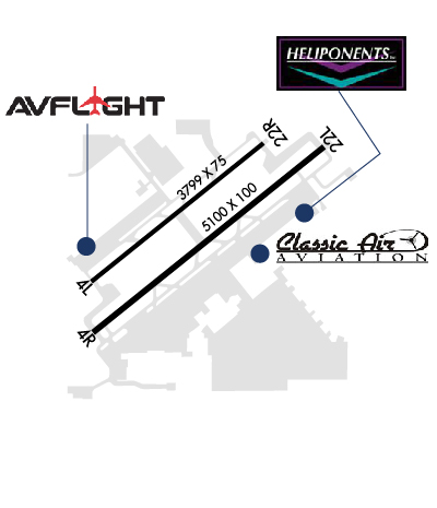
| Lat: N 3327.7 Long: W 11143.7 Elev: 1394 Var: -12 Longest Runway: 5100 | ||
| Dept. ATIS: 118.25 Arr. ATIS: 118.25 Ground: 121.3 Tower: 124.6 | ||
| |||||||||||||||||||||||||||||||||||||||||||||||||||||||||||||||||||||
| |||||||||||||||||||||||||||||||||||||||||||||||||||||||||||||||||||||
| |||||||||||||||||||||||||||||||||||||||||||||||||||||||||||||||||||||
| |||||||||||||||||||||||||||||||||||||||||||||||||||||||||||||||||||||
| Rwy | Rwy | |||||||
| 3799x75 | 3799' | 3799x75 | 3799' | |||||
| 5100x100 | 5100' | 5100x100 | 5100' | |||||
| Runway ID | Single Wheel | Double Wheel | Double Tandem Wheel | Dual Double Wheel |
| 04L/22R | 12,500 | N/A | N/A | N/A |
| 04R/22L | 38,000 | 60,000 | 90,000 | N/A |
| These numbers are Advisory and are not limits. The Airport Manager should have more accurate Weight Limits | ||||
 Airport Diagram might not be current. | |
| Facility Name: | FALCON FLD |
| City Name: | MESA |
| County: | MARICOPA |
| State abbrev: | AZ |
| State Name: | ARIZONA |
| Ownership: | PUBLICLY OWNED |
| Use: | OPEN TO THE PUBLIC |
| Owner's Name: | CITY OF MESA |
| Address: | BOX 1466 |
| MEZA, AZ 85211-1466 | |
| Owner's Phone: | 480-644-2450 |
| Manager's Name: | CORINNE NYSTROM |
| Address: | 4800 E. FALCON DR. |
| MESA, AZ 85215 | |
| Phone: | 480-644-2450 |
| FAA Region: | WESTERN-PACIFIC |
| FAA Field Office: | PHX |
| Date | Sunrise | Sunset |
|---|---|---|
| 09/24/21 Friday | 6:16 | 18:21 |
| 09/25/21 Saturday | 6:17 | 18:20 |
| 09/26/21 Sunday | 6:18 | 18:18 |
| 09/27/21 Monday | 6:18 | 18:17 |
| 09/28/21 Tuesday | 6:19 | 18:16 |
| 09/29/21 Wednesday | 6:20 | 18:14 |
| 09/30/21 Thursday | 6:20 | 18:13 |
| 10/01/21 Friday | 6:21 | 18:12 |
| 10/02/21 Saturday | 6:22 | 18:10 |
| 10/03/21 Sunday | 6:23 | 18:09 |
| 10/04/21 Monday | 6:23 | 18:08 |
| 10/05/21 Tuesday | 6:24 | 18:06 |
| 10/06/21 Wednesday | 6:25 | 18:05 |
| 10/07/21 Thursday | 6:25 | 18:04 |
| Airport Attendance Schedule | CONTINUOUS; FOR SVC CTC FBO ON 122.950 (480-832-2582). |
| Airport Status | OPERATIONAL (This Status can change at any time - please check NOTAMS) |
| Airport Lighting Schedule | WHEN ATCT CLSD MIRL RWY 04R/22L AND TWY LGTS PRESET LOW INTST TO INCREASE INTST ACTVT - CTAF. MIRL RWY 04L/22R UNAVBL WHEN ATCT CLSD. |
| Airport Storage Available | Tie Downs |
| Extra Services Available | Air Ambulance, Avionics, Charter, Flight Instruction, Aircraft Rental, Aircraft Sales |
| Wind Indicator | YES - (lighted) |
| Control Tower | YES |
| CTAF Frequency | 124.600 |
| Unicom Frequency | 122.950 |
| Rotating Beacon Color | CLEAR-GREEN (Light Land Airport) |
| Segmented Circle | YES |
| Landing Fee | NO |
| Airport Inspected | STATE - performed by PRIVATE CONTRACT PERSONNEL |
| Inspection Date | 04/13/2021 |
| Type of Fuel Available | Grade 100LL, JET A-1 (icing inhibitor, freeze point -50C) |
| Airframe Repair Service | MAJOR |
| Power Plant Repair Service | MAJOR |
| Latitude | N3327.7 |
| Longitude | W11143.7 (ESTIMATED) |
| Arpt Elevation | 1394ft (SURVEYED) |
| Magnetic Variation | 12E |
| 5 miles NE | of MESA |
| Traffic Pattern Altitude | 1308; TPA FOR LIGHT ACFT 1006 FT AGL; TPA FOR LARGE & TURBINE-POWERED ACFT 1506 FT AGL; TPA 506 FT AGL FOR ROTORCRAFT. |
| Sectional Chart | PHOENIX |
| Operations (Reported) | Yearly | Avg. Daily |
|---|---|---|
| General Aviation Transient | 56550 | 155 |
| General Aviation Local | 182216 | 499 |
| Air Taxi | 72258 | 198 |
| Commerical | 1 | 0 |
| Commuter | 0 | 0 |
| Military | 3142 | 9 |
| Aircraft based on Field | |
|---|---|
| General Aviation Singles | 516 |
| General Aviation Multi | 76 |
| Jet Aircraft | 8 |
| General Aviation Helicopters | 37 |
| Military Aircraft | 0 |
| Gliders | 1 |
| Ultralights | 0 |
| FSS on field | NO |
| FSS tie-in | PRESCOTT |
| FSS Phone | 1-800-WX-BRIEF |
| Who issues Notams | FFZ |
| Notam D service at airport | YES |
| ARTCC Name | ALBUQUERQUE |
| Airport Certification | |
| Aircraft Rescue & Firefighting Index | None |
| Airport of Entry | No |
| Custom Landing Rights | No |
| Joint Civil/Military | No |
| Military Landing rights | YES |
| NATIONAL PLAN OF INTEGRATED AIRPORT SYSTEMS (NPIAS) |
| GRANT AGREEMENTS UNDER FAAP/ADAP/AIP |
| SURPLUS PROPERTY AGREEMENT UNDER PUBLIC LAW 289 |
| ASSURANCES PURSUANT TO TITLE VI, CIVIL RIGHTS ACT OF 1964 |
| VOLUNTARY NOISE ABATEMENT PROCEDURES IN EFFECT. FOR NOISE ABATEMENT PROCEDURES CALL 480-644-6647. |
| RISING TERRAIN NE OF ARPT. |
| BIRDS INVOF ARPT. COYOTES AND OTHER WILDLIFE OCNL CROSSING RWYS AND TWYS. |
| RWYS 04R & 04L ARE THE PREFERRED RWYS WHEN WIND CONDS ARE LESS THAN 5 KNOTS. |
| REPETITIVE TRNG OPNS USE RWY 04L/22R WHENEVER POSSIBLE. AVOID REPETITIVE TRNG OPNS 2200-0530. |
| RWY 04L/22R CLSD WHEN ATCT CLSD. |
| BLAST PADS INSTALLED ON RWY 4L AND 22R. BLAST PADS DIMENSIONS, 150 FT X 95 FT. |
| WHEN ATCT CLSD, FOR CD CTC PHOENIX APPROACH AT 602-306-2565. |
| 2786 FT MSL UNLGTD MTN 5 MI EAST. |
| TURBULENT CONDS MAY BE ENCOUNTERED BLO 500 FT AGL NEAR GND TEST SITE 1.5 MILES NORTH OF ARPT. DO NOT MISTAKE BOEING HELIPORT 1 MILE NORTH FOR A RY. |
| TERMINAL APRON AREA LTD TO 45,000 LBS GWT SINGLE WHEEL OR 75,000 LBS GWT DUAL WHEEL BY AIRPORT DIRECTOR. |
| EXTENSIVE FIXED WING AND ROTORCRAFT FLIGHT TRAINING ACTIVITY. |
Airport Communications & Frequencies:
| |||||||||||||||||||||||
| Runway: 04L | Runway: 22R | ||
| Mag heading: | 39° | Mag heading: | 219° |
| Rwy Slope: | .53% Up | Rwy Slope: | -.53% Down |
| Approach: | Approach: | ||
| Pattern: | Left Traffic | Pattern: | Right Traffic |
| Markings: | BASIC | Markings: | BASIC |
| Marking Condition: | GOOD | Marking Condition: | GOOD |
| Arresting Dev: | Arresting Dev: | ||
| Lat & Long: | N3327.5 W11144.1 | Lat. & Long.: | N3327.9 W11143.5 |
| Elev: | 1365.7 ft. MSL | Elev: | 1386.0 ft. MSL |
| TCH: | 42 ft. AGL | TCH: | 42 ft. AGL |
| Visual Glide Path: | 4.00 degrees | Visual Glide Path: | 4.00 degrees |
| Displaced Threshold: | No | Displaced Threshold: | No |
| Touchdown Zone: | YES | Touchdown Zone: | YES |
| Touchdown Elev.: | 1382.6 feet | Touchdown Elev.: | 1386.0 feet |
| Visual Glide Slope: | 2-Light PAPI on LEFT side of Runway | Visual Glide Slope: | 2-Light PAPI on LEFT side of Runway |
| RVR Equipment: | RVR Equipment: | ||
| RVV Equipment: | NO | RVV Equipment: | NO |
| Approach Lights: | Approach Lights: | ||
| REIL: | YES | REIL: | YES |
| Centerline Lights: | NO | Centerline Lights: | NO |
| Touchdown lights: | NO | Touchdown lights: | NO |
| Runway Category: | Runway with a Non-precision Approach | Runway Category: | Runway with a Visual Approach |
| Declared Distances: | Declared Distances: |
| Runway: 04R | Runway: 22L | ||
| Mag heading: | 39° | Mag heading: | 219° |
| Rwy Slope: | .56% Up | Rwy Slope: | -.56% Down |
| Approach: | Approach: | ||
| Pattern: | Left Traffic | Pattern: | Left Traffic; WHEN ATCT CLOSED RWY 22L HAS RIGHT TRAFFIC. |
| Markings: | NONPRECISION INSTRUMENT | Markings: | NONPRECISION INSTRUMENT |
| Marking Condition: | GOOD | Marking Condition: | GOOD |
| Arresting Dev: | Arresting Dev: | ||
| Lat & Long: | N3327.4 W11144.0 | Lat. & Long.: | N3327.9 W11143.3 |
| Elev: | 1365.6 ft. MSL | Elev: | 1394.0 ft. MSL |
| TCH: | 42 ft. AGL | TCH: | 49 ft. AGL |
| Visual Glide Path: | 4.00 degrees | Visual Glide Path: | 4.00 degrees |
| Displaced Threshold: | No | Displaced Threshold: | No |
| Touchdown Zone: | YES | Touchdown Zone: | YES |
| Touchdown Elev.: | 1383.6 feet | Touchdown Elev.: | 1394.0 feet |
| Visual Glide Slope: | 4-Light PAPI on LEFT side of Runway | Visual Glide Slope: | 4-Light PAPI on LEFT side of Runway; PAPI DOES NOT PROVIDE OBSTRUCTION CLEARANCE BEYOND 4.0 NM FROM THRESHOLD. |
| RVR Equipment: | RVR Equipment: | ||
| RVV Equipment: | NO | RVV Equipment: | NO |
| Approach Lights: | Approach Lights: | ||
| REIL: | YES | REIL: | YES |
| Centerline Lights: | NO | Centerline Lights: | NO |
| Touchdown lights: | NO | Touchdown lights: | NO |
| Runway Category: | Runway with a Non-precision Approach having visibility minimums greater than 3/4 mile | Runway Category: | Runway with a Visual Approach |
| Declared Distances: | Declared Distances: | ||
| Obstructions: | ROAD | Obstructions: | |
| Marked: | NOT Marked/Lighted | Marked: | |
| Clearance slope: | 27:1 | Clearance slope: | 20:1 |
| Obstruction height: | 8 feet AGL | Obstruction height: | |
| Dist. from runway: | 420 feet | Dist. from runway: | |
| Centerline offset: | 270 left of centerline | Centerline offset: | |
| Comments: | Comments: |
Thanks for using FltPlan.com
all rights reserved © 1999-2021 by Flight Plan LLC