
| FERGUS FALLS MUN.-MICKELSON FERGUS FALLS MN |
| |
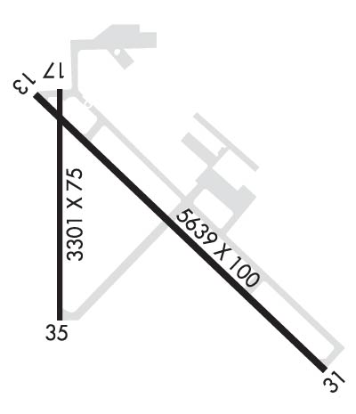
| Lat: N 4617.1 Long: W 09609.4 Elev: 1182 Var: -05 Longest Runway: 5639 | ||
| AWOS: 110.4 CTAF: 122.8 | ||
| ||||||||||||||||||||||||||||||||||||||||||||
| ||||||||||||||||||||||||||||||||||||||||||||
| ||||||||||||||||||||||||||||||||||||||||||||
| Rwy | Rwy | |||||||
| 5639x100 | 5639' | 5639x100 | 5639' | 111.50 - 308° | ||||
| 3299x75 | 3299' | 3299x75 | 3299' | |||||
| Runway ID | Single Wheel | Double Wheel | Double Tandem Wheel | Dual Double Wheel |
| 13/31 | 60,000 | 90,000 | N/A | N/A |
| 17/35 | 16,000 | 22,000 | N/A | N/A |
| These numbers are Advisory and are not limits. The Airport Manager should have more accurate Weight Limits | ||||
 Airport Diagram might not be current. | |
| Facility Name: | FERGUS FALLS RGNL |
| City Name: | FERGUS FALLS |
| County: | OTTER TAIL |
| State abbrev: | MN |
| State Name: | MINNESOTA |
| Ownership: | PUBLICLY OWNED |
| Use: | OPEN TO THE PUBLIC |
| Owner's Name: | CITY OF FERGUS FALLS |
| Address: | 112 W WASHINGTON AVE, PO BOX 868, PO BOX 868 |
| FERGUS FALLS, MN 56537-2568 | |
| Owner's Phone: | 218-332-5435 |
| Manager's Name: | SKY CREW SERVICES LLC |
| Address: | 4005 STATE HIGHWAY 210 W |
| FERGUS FALLS, MN 56537-4005 | |
| Phone: | 218-739-3733 |
| FAA Region: | GREAT LAKES |
| FAA Field Office: | DMA |
| Date | Sunrise | Sunset |
|---|---|---|
| 06/08/26 Monday | 5:33 | 21:14 |
| 06/09/26 Tuesday | 5:33 | 21:15 |
| 06/10/26 Wednesday | 5:33 | 21:16 |
| 06/11/26 Thursday | 5:32 | 21:16 |
| 06/12/26 Friday | 5:32 | 21:17 |
| 06/13/26 Saturday | 5:32 | 21:17 |
| 06/14/26 Sunday | 5:32 | 21:18 |
| 06/15/26 Monday | 5:32 | 21:18 |
| 06/16/26 Tuesday | 5:32 | 21:19 |
| 06/17/26 Wednesday | 5:32 | 21:19 |
| 06/18/26 Thursday | 5:32 | 21:19 |
| 06/19/26 Friday | 5:32 | 21:20 |
| 06/20/26 Saturday | 5:32 | 21:20 |
| 06/21/26 Sunday | 5:32 | 21:20 |
| Airport Attendance Schedule | MON-FRI 0800-1700, SAT 0900-1400; FOR ATTENDANT AFT HRS CALL AMGR. |
| Airport Status | OPERATIONAL (This Status can change at any time - please check NOTAMS) |
| Airport Lighting Schedule | ACTVT MALSR RWY 31; REIL RWY 13 & 35; PAPI RWY 13 & 31; MIRL RWY 13/31 & 17/35 - CTAF. |
| Airport Storage Available | Tie Downs, Hanger |
| Extra Services Available | Crop Dusting, Aircraft Rental, Aircraft Sales |
| Wind Indicator | YES - (lighted) |
| Control Tower | NO |
| CTAF Frequency | 122.800 |
| Unicom Frequency | 122.800 |
| Rotating Beacon Color | WG |
| Segmented Circle | NO |
| Landing Fee | NO |
| Airport Inspected | STATE - performed by STATE AERONAUTICAL PERSONNEL |
| Inspection Date | 07/03/2024 |
| Type of Fuel Available | Grade 100LL, JET A (freeze point -40C); -10FUEL AVBL H24 VIA CREDIT CARD. |
| Airframe Repair Service | MINOR |
| Power Plant Repair Service | MINOR |
| Latitude | N4617.1 |
| Longitude | W09609.4 (ESTIMATED) |
| Arpt Elevation | 1182ft (SURVEYED) |
| Magnetic Variation | 05E |
| 3 miles W | of FERGUS FALLS |
| Traffic Pattern Altitude | |
| Sectional Chart | TWIN CITIES |
| Operations (Reported) | Yearly | Avg. Daily |
|---|---|---|
| General Aviation Transient | 0 | 0 |
| General Aviation Local | 0 | 0 |
| Air Taxi | 0 | 0 |
| Commerical | 0 | 0 |
| Commuter | 0 | 0 |
| Military | 0 | 0 |
| Aircraft based on Field | |
|---|---|
| General Aviation Singles | 0 |
| General Aviation Multi | 0 |
| Jet Aircraft | 0 |
| General Aviation Helicopters | 0 |
| Military Aircraft | 0 |
| Gliders | 0 |
| Ultralights | 0 |
| FSS on field | NO |
| FSS tie-in | PRINCETON |
| FSS Phone | 1-800-WX-BRIEF |
| Who issues Notams | FFM |
| Notam D service at airport | YES |
| ARTCC Name | MINNEAPOLIS |
| Airport Certification | |
| Aircraft Rescue & Firefighting Index | None |
| Airport of Entry | No |
| Custom Landing Rights | No |
| Joint Civil/Military | No |
| Military Landing rights | YES |
| NATIONAL PLAN OF INTEGRATED AIRPORT SYSTEMS (NPIAS) |
| GRANT AGREEMENTS UNDER FAAP/ADAP/AIP |
| ASSURANCES PURSUANT TO TITLE VI, CIVIL RIGHTS ACT OF 1964 |
| DEER & WATERFOWL ON & INVOF ARPT. |
| ULTRALIGHTS ON & INVOF ARPT. ULTRALIGHT PATTERN 1800 FT MSL. |
| FOR CD IF UNA TO CTC ON FSS FREQ, CTC MINNEAPOLIS ARTCC AT 651-463-5588. |
Airport Communications & Frequencies:
| |||||||||
| Runway: 13 | Runway: 31 | ||
| Mag heading: | 128° | Mag heading: | 308° |
| Rwy Slope: | -.11% Down | Rwy Slope: | .11% Up |
| Approach: | Approach: | ILS | |
| Pattern: | Left Traffic | Pattern: | Left Traffic |
| Markings: | PRECISION INSTRUMENT | Markings: | PRECISION INSTRUMENT |
| Marking Condition: | FAIR | Marking Condition: | FAIR |
| Arresting Dev: | Arresting Dev: | ||
| Lat & Long: | N4617.4 W09609.7 | Lat. & Long.: | N4616.7 W09608.8 |
| Elev: | 1181.7 ft. MSL | Elev: | 1175.6 ft. MSL |
| TCH: | 52 ft. AGL | TCH: | 52 ft. AGL |
| Visual Glide Path: | 3.00 degrees | Visual Glide Path: | 3.00 degrees |
| Displaced Threshold: | No | Displaced Threshold: | No |
| Touchdown Zone: | YES | Touchdown Zone: | YES |
| Touchdown Elev.: | 1182.0 feet | Touchdown Elev.: | 1181.9 feet |
| Visual Glide Slope: | 4-Light PAPI on LEFT side of Runway | Visual Glide Slope: | 4-Light PAPI on LEFT side of Runway |
| RVR Equipment: | RVR Equipment: | ||
| RVV Equipment: | NO | RVV Equipment: | NO |
| Approach Lights: | Approach Lights: | MALSR - 1,400 foot medium intensity approach lighting system with runway alignment indicator lights | |
| REIL: | YES | REIL: | NO |
| Centerline Lights: | NO | Centerline Lights: | NO |
| Touchdown lights: | NO | Touchdown lights: | NO |
| Runway Category: | D | Runway Category: | Precision Instrument Runway |
| Declared Distances: | Declared Distances: |
| Runway: 17 | Runway: 35 | ||
| Mag heading: | 174° | Mag heading: | 354° |
| Rwy Slope: | -.74% Down | Rwy Slope: | .74% Up |
| Approach: | Approach: | ||
| Pattern: | Left Traffic | Pattern: | Left Traffic |
| Markings: | NONPRECISION INSTRUMENT | Markings: | NONPRECISION INSTRUMENT |
| Marking Condition: | FAIR | Marking Condition: | FAIR |
| Arresting Dev: | Arresting Dev: | ||
| Lat & Long: | N4617.4 W09609.7 | Lat. & Long.: | N4616.8 W09609.7 |
| Elev: | 1182.2 ft. MSL | Elev: | 1157.7 ft. MSL |
| TCH: | TCH: | ||
| Visual Glide Path: | Visual Glide Path: | ||
| Displaced Threshold: | No | Displaced Threshold: | No |
| Touchdown Zone: | YES | Touchdown Zone: | YES |
| Touchdown Elev.: | 1182.4 feet | Touchdown Elev.: | 1181.4 feet |
| Visual Glide Slope: | Visual Glide Slope: | ||
| RVR Equipment: | RVR Equipment: | ||
| RVV Equipment: | NO | RVV Equipment: | NO |
| Approach Lights: | Approach Lights: | ||
| REIL: | NO | REIL: | YES |
| Centerline Lights: | NO | Centerline Lights: | NO |
| Touchdown lights: | NO | Touchdown lights: | NO |
| Runway Category: | Runway with a Visual Approach | Runway Category: | Runway with a Non-precision Approach having visibility minimums greater than 3/4 mile |
| Declared Distances: | Declared Distances: |
Thanks for using FltPlan.com
all rights reserved © 1999-2026 by Flight Plan LLC
