
| FAIRFIELD MUNI FAIRFIELD IA |
| |
| Lat: N 4103.3 Long: W 09158.8 Elev: 801 Var: -00 Longest Runway: 5503 | ||
| AWOS: 132.02 CTAF: 122.7 | ||
| ||||||
| ||||||
|
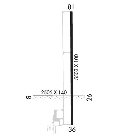
| Rwy | Rwy | |||||||
| 2505x140 | 2505' | 2505x140 | 2505' | |||||
| 5503x100 | 5503' | 5503x100 | 5503' | |||||
| Runway ID | Single Wheel | Double Wheel | Double Tandem Wheel | Dual Double Wheel |
| 08/26 | N/A | N/A | N/A | N/A |
| 18/36 | 30,000 | 45,000 | N/A | N/A |
| These numbers are Advisory and are not limits. The Airport Manager should have more accurate Weight Limits | ||||
 Airport Diagram might not be current. | |
| Facility Name: | FAIRFIELD MUNI |
| City Name: | FAIRFIELD |
| County: | JEFFERSON |
| State abbrev: | IA |
| State Name: | IOWA |
| Ownership: | PUBLICLY OWNED |
| Use: | OPEN TO THE PUBLIC |
| Owner's Name: | CITY OF FAIRFIELD |
| Address: | 118 SOUTH MAIN |
| FAIRFIELD, IA 52556 | |
| Owner's Phone: | 641-472-6193 |
| Manager's Name: | ROBERT LYONS |
| Address: | 2013 AIRPORT RD; EMAIL ADDRESS: FFSLYONS@YAHOO.COM (ALL LOWER CASE) |
| FAIRFIELD, IA 52556 | |
| Phone: | 641-472-3166 |
| FAA Region: | CENTRAL |
| FAA Field Office: | NONE |
| Date | Sunrise | Sunset |
|---|---|---|
| 09/24/21 Friday | 6:57 | 19:02 |
| 09/25/21 Saturday | 6:58 | 19:00 |
| 09/26/21 Sunday | 6:59 | 18:59 |
| 09/27/21 Monday | 7:00 | 18:57 |
| 09/28/21 Tuesday | 7:01 | 18:55 |
| 09/29/21 Wednesday | 7:02 | 18:54 |
| 09/30/21 Thursday | 7:03 | 18:52 |
| 10/01/21 Friday | 7:04 | 18:50 |
| 10/02/21 Saturday | 7:05 | 18:49 |
| 10/03/21 Sunday | 7:06 | 18:47 |
| 10/04/21 Monday | 7:07 | 18:45 |
| 10/05/21 Tuesday | 7:08 | 18:44 |
| 10/06/21 Wednesday | 7:10 | 18:42 |
| 10/07/21 Thursday | 7:11 | 18:40 |
| Airport Attendance Schedule | MON-FRI 0730-1630, SAT - SUN ON CALL; ARPT UNATNDD ALL MAJOR HOLIDAYS |
| Airport Status | OPERATIONAL (This Status can change at any time - please check NOTAMS) |
| Airport Lighting Schedule | ACTVT MIRL RY 18/36; PAPI AND REIL RYS 18 & 36 - CTAF. |
| Airport Storage Available | Tie Downs, Hanger |
| Extra Services Available | Charter, Flight Instruction, Aircraft Rental, Aircraft Sales |
| Wind Indicator | YES - (lighted) |
| Control Tower | NO |
| CTAF Frequency | 122.700 |
| Unicom Frequency | 122.700 |
| Rotating Beacon Color | CLEAR-GREEN (Light Land Airport) |
| Segmented Circle | YES |
| Landing Fee | NO |
| Airport Inspected | STATE - performed by STATE AERONAUTICAL PERSONNEL |
| Inspection Date | 08/10/2020 |
| Type of Fuel Available | Grade 100LL, JET A (freeze point -40C) |
| Airframe Repair Service | MAJOR |
| Power Plant Repair Service | MAJOR |
| Latitude | N4103.3 |
| Longitude | W09158.8 (ESTIMATED) |
| Arpt Elevation | 800ft (SURVEYED) |
| Magnetic Variation | 00E |
| 3 miles NW | of FAIRFIELD |
| Traffic Pattern Altitude | 1001 |
| Sectional Chart | CHICAGO |
| Operations (Reported) | Yearly | Avg. Daily |
|---|---|---|
| General Aviation Transient | 1998 | 5 |
| General Aviation Local | 2427 | 7 |
| Air Taxi | 112 | 0 |
| Commerical | 0 | 0 |
| Commuter | 0 | 0 |
| Military | 463 | 1 |
| Aircraft based on Field | |
|---|---|
| General Aviation Singles | 16 |
| General Aviation Multi | 1 |
| Jet Aircraft | 2 |
| General Aviation Helicopters | 0 |
| Military Aircraft | 0 |
| Gliders | 0 |
| Ultralights | 0 |
| FSS on field | NO |
| FSS tie-in | FORT DODGE |
| FSS Phone | 1-800-WX-BRIEF |
| Who issues Notams | FFL |
| Notam D service at airport | YES |
| ARTCC Name | CHICAGO |
| Airport Certification | |
| Aircraft Rescue & Firefighting Index | None |
| Airport of Entry | No |
| Custom Landing Rights | No |
| Joint Civil/Military | No |
| Military Landing rights | YES |
| NATIONAL PLAN OF INTEGRATED AIRPORT SYSTEMS (NPIAS) |
| GRANT AGREEMENTS UNDER FAAP/ADAP/AIP |
| ASSURANCES PURSUANT TO TITLE VI, CIVIL RIGHTS ACT OF 1964 |
| RY 36 IS CALM WIND RY. |
| BIRDS ON & INVOF ARPT. |
| FOR CD CTC CHICAGO ARTCC AT 630-906-8921. |
| RWY 08/2 6 CLSD NOV-MAR. |
Airport Communications & Frequencies:
| |||||||||
| Runway: 08 | Runway: 26 | ||
| Mag heading: | 90° | Mag heading: | 270° |
| Rwy Slope: | -.10% Down | Rwy Slope: | .10% Up |
| Approach: | Approach: | ||
| Pattern: | Left Traffic | Pattern: | Left Traffic |
| Markings: | Markings: | ||
| Marking Condition: | 08/26 THRS & EDGES MARKED WITH YELLOW CONES. THR CONES HAVE RED/GREEN REFLECTOR TAPE & EDGE CONES HAVE WHITE. | Marking Condition: | |
| Arresting Dev: | Arresting Dev: | ||
| Lat & Long: | N4103.2 W09159.2 | Lat. & Long.: | N4103.2 W09158.7 |
| Elev: | 792.8 ft. MSL | Elev: | 790.3 ft. MSL |
| TCH: | TCH: | ||
| Visual Glide Path: | Visual Glide Path: | ||
| Displaced Threshold: | No | Displaced Threshold: | No |
| Touchdown Zone: | YES | Touchdown Zone: | YES |
| Touchdown Elev.: | 792.8 feet | Touchdown Elev.: | 792.8 feet |
| Visual Glide Slope: | Visual Glide Slope: | ||
| RVR Equipment: | RVR Equipment: | ||
| RVV Equipment: | NO | RVV Equipment: | NO |
| Approach Lights: | Approach Lights: | ||
| REIL: | NO | REIL: | NO |
| Centerline Lights: | NO | Centerline Lights: | NO |
| Touchdown lights: | NO | Touchdown lights: | NO |
| Runway Category: | Runway with a Visual Approach | Runway Category: | Runway with a Visual Approach |
| Declared Distances: | Declared Distances: | ||
| Obstructions: | FENCE | Obstructions: | FENCE |
| Marked: | NOT Marked/Lighted | Marked: | NOT Marked/Lighted |
| Clearance slope: | 20:1 | Clearance slope: | 20:1 |
| Obstruction height: | 6 feet AGL | Obstruction height: | 4 feet AGL |
| Dist. from runway: | 120 feet | Dist. from runway: | 80 feet |
| Centerline offset: | Centerline offset: | ||
| Comments: | Comments: |
| Runway: 18 | Runway: 36 | ||
| Mag heading: | 180° | Mag heading: | 360° |
| Rwy Slope: | -.10% Down | Rwy Slope: | .10% Up |
| Approach: | Approach: | ||
| Pattern: | Left Traffic | Pattern: | Left Traffic |
| Markings: | NONPRECISION INSTRUMENT | Markings: | NONPRECISION INSTRUMENT |
| Marking Condition: | FAIR | Marking Condition: | FAIR |
| Arresting Dev: | Arresting Dev: | ||
| Lat & Long: | N4103.9 W09158.8 | Lat. & Long.: | N4103.0 W09158.8 |
| Elev: | 797.2 ft. MSL | Elev: | 791.6 ft. MSL |
| TCH: | 40 ft. AGL | TCH: | 40 ft. AGL |
| Visual Glide Path: | 3.00 degrees | Visual Glide Path: | 3.00 degrees |
| Displaced Threshold: | No | Displaced Threshold: | No |
| Touchdown Zone: | YES | Touchdown Zone: | YES |
| Touchdown Elev.: | 800.9 feet | Touchdown Elev.: | 798.7 feet |
| Visual Glide Slope: | 4-Light PAPI on LEFT side of Runway | Visual Glide Slope: | 4-Light PAPI on LEFT side of Runway |
| RVR Equipment: | RVR Equipment: | ||
| RVV Equipment: | NO | RVV Equipment: | NO |
| Approach Lights: | Approach Lights: | ||
| REIL: | YES | REIL: | YES |
| Centerline Lights: | NO | Centerline Lights: | NO |
| Touchdown lights: | NO | Touchdown lights: | NO |
| Runway Category: | Runway with a Non-precision Approach having visibility minimums greater than 3/4 mile | Runway Category: | Runway with a Non-precision Approach having visibility minimums greater than 3/4 mile |
| Declared Distances: | Declared Distances: | ||
| Obstructions: | Obstructions: | ROAD | |
| Marked: | Marked: | NOT Marked/Lighted | |
| Clearance slope: | 50:1 | Clearance slope: | 50:1 |
| Obstruction height: | Obstruction height: | 17 feet AGL | |
| Dist. from runway: | Dist. from runway: | 1054 feet | |
| Centerline offset: | Centerline offset: | ||
| Comments: | Comments: |
Thanks for using FltPlan.com
all rights reserved © 1999-2021 by Flight Plan LLC
