
| ATLANTA REGIONAL -FALCON FIELD ATLANTA GA |
| |
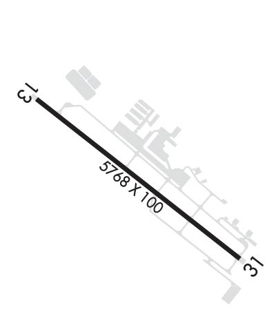
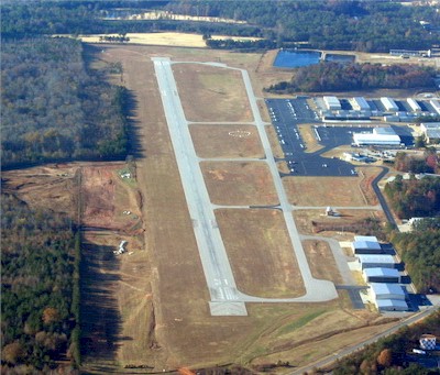
| Lat: N 3321.5 Long: W 08434.4 Elev: 808 Var: +05 Longest Runway: 5768 | ||
| Clr Del: 119.8 AWOS: 118.52 CTAF: 123.05 | ||
| ||||||||||||||||||||||||||||||||||||||||||||||||||||||||||||||||||||
| ||||||||||||||||||||||||||||||||||||||||||||||||||||||||||||||||||||
| ||||||||||||||||||||||||||||||||||||||||||||||||||||||||||||||||||||
| Rwy | Rwy | |||||||
| 5768x100 | 5219' | 5768x100 | 5568' | 111.95 - 313° | ||||
| Runway ID | Single Wheel | Double Wheel | Double Tandem Wheel | Dual Double Wheel |
| 13/31 | 48,000 | 60,000 | N/A | N/A |
| H1 | N/A | N/A | N/A | N/A |
| These numbers are Advisory and are not limits. The Airport Manager should have more accurate Weight Limits | ||||
 Airport Diagram might not be current. | |
| Facility Name: | ATLANTA RGNL FALCON FLD |
| City Name: | ATLANTA |
| County: | FAYETTE |
| State abbrev: | GA |
| State Name: | GEORGIA |
| Ownership: | PUBLICLY OWNED |
| Use: | OPEN TO THE PUBLIC |
| Owner's Name: | PEACHTREE CITY ARPT AUTH |
| Address: | 7 FALCON DRIVE |
| PEACHTREE CITY, GA 30269 | |
| Owner's Phone: | 770-487-2225 |
| Manager's Name: | HOPE MACALUSO |
| Address: | 7 FALCON DRIVE |
| PEACHTREE CITY, GA 30269 | |
| Phone: | 770-487-2225 |
| FAA Region: | SOUTHERN |
| FAA Field Office: | ATL |
| Date | Sunrise | Sunset |
|---|---|---|
| 06/07/26 Sunday | 6:28 | 20:46 |
| 06/08/26 Monday | 6:28 | 20:46 |
| 06/09/26 Tuesday | 6:28 | 20:47 |
| 06/10/26 Wednesday | 6:28 | 20:47 |
| 06/11/26 Thursday | 6:28 | 20:48 |
| 06/12/26 Friday | 6:28 | 20:48 |
| 06/13/26 Saturday | 6:28 | 20:49 |
| 06/14/26 Sunday | 6:28 | 20:49 |
| 06/15/26 Monday | 6:28 | 20:49 |
| 06/16/26 Tuesday | 6:28 | 20:50 |
| 06/17/26 Wednesday | 6:28 | 20:50 |
| 06/18/26 Thursday | 6:29 | 20:50 |
| 06/19/26 Friday | 6:29 | 20:51 |
| 06/20/26 Saturday | 6:29 | 20:51 |
| Airport Attendance Schedule | 7 Days A Week 0700-2000, DECEMBER 25 CLSD, DECEMBER 24 0700-1200 |
| Airport Status | OPERATIONAL (This Status can change at any time - please check NOTAMS) |
| Airport Lighting Schedule | MIRL RWY 13/31 PRESET LOW INTST DUSK-2200; TO INCR INTST & ACTVT AFTER 2200 - CTAF. ACTVT ODALS RWY 31; PAPI RWYS 13 & 31; REIL RWY 13 - CTAF. |
| Airport Storage Available | Tie Downs, Hanger |
| Extra Services Available | Avionics, Charter, Flight Instruction, Aircraft Rental, Aircraft Sales, Annual Surveying |
| Wind Indicator | YES - (lighted) |
| Control Tower | NO |
| CTAF Frequency | 123.050 |
| Unicom Frequency | 123.050 |
| Rotating Beacon Color | WG |
| Segmented Circle | YES |
| Landing Fee | NO |
| Airport Inspected | STATE - performed by STATE AERONAUTICAL PERSONNEL |
| Inspection Date | 04/18/2025 |
| Type of Fuel Available | Grade 100LL, JET A |
| Airframe Repair Service | MAJOR |
| Power Plant Repair Service | MAJOR |
| Latitude | N3321.5 |
| Longitude | W08434.4 (ESTIMATED) |
| Arpt Elevation | 807ft (SURVEYED) |
| Magnetic Variation | 05W |
| 25 miles SW | of ATLANTA |
| Traffic Pattern Altitude | |
| Sectional Chart | ATLANTA |
| Operations (Reported) | Yearly | Avg. Daily |
|---|---|---|
| General Aviation Transient | 0 | 0 |
| General Aviation Local | 0 | 0 |
| Air Taxi | 0 | 0 |
| Commerical | 0 | 0 |
| Commuter | 0 | 0 |
| Military | 0 | 0 |
| Aircraft based on Field | |
|---|---|
| General Aviation Singles | 0 |
| General Aviation Multi | 0 |
| Jet Aircraft | 0 |
| General Aviation Helicopters | 0 |
| Military Aircraft | 0 |
| Gliders | 0 |
| Ultralights | 0 |
| FSS on field | NO |
| FSS tie-in | MACON |
| FSS Phone | 1-800-WX-BRIEF |
| Who issues Notams | FFC |
| Notam D service at airport | YES |
| ARTCC Name | ATLANTA |
| Airport Certification | |
| Aircraft Rescue & Firefighting Index | None |
| Airport of Entry | No |
| Custom Landing Rights | No |
| Joint Civil/Military | No |
| Military Landing rights | No |
| NATIONAL PLAN OF INTEGRATED AIRPORT SYSTEMS (NPIAS) |
| GRANT AGREEMENTS UNDER FAAP/ADAP/AIP |
| ASSURANCES PURSUANT TO TITLE VI, CIVIL RIGHTS ACT OF 1964 |
| DEER ON AND INVOF OF ARPT. |
| ARPT MOWING IN PROG SPRING THRU AUTUMN. |
| PERIODIC CRANE OPS INVOF ARPT |
| FOR CD CTC ATLANTA APCH AT 678-364-6131. |
| BIRD ACT INCL GEESE INVOF ARPT |
| BE ALERT: FRQ FLT TRG IN AREA. |
| NO AP LDG FEES |
| THANKSGIVING FIXED BASED OPR OPN 0700-1200 |
| RWY 13/3 1 PCR VALUE: 324/F/D/X/T |
Airport Communications & Frequencies:
| ||||||||||||||||
| Runway: 13 | Runway: 31 | ||
| Mag heading: | 133° | Mag heading: | 313° |
| Rwy Slope: | .12% Up | Rwy Slope: | -.12% Down |
| Approach: | Approach: | ILS/DME | |
| Pattern: | Right Traffic | Pattern: | Left Traffic |
| Markings: | NONPRECISION INSTRUMENT | Markings: | PRECISION INSTRUMENT |
| Marking Condition: | GOOD | Marking Condition: | GOOD |
| Arresting Dev: | Arresting Dev: | ||
| Lat & Long: | N3321.8 W08434.8 | Lat. & Long.: | N3321.2 W08433.9 |
| Elev: | 800.8 ft. MSL | Elev: | 807.7 ft. MSL |
| TCH: | 38 ft. AGL | TCH: | 45 ft. AGL |
| Visual Glide Path: | 3.50 degrees | Visual Glide Path: | 3.00 degrees |
| Displaced Threshold: | 549 feet | Displaced Threshold: | 200 feet |
| Touchdown Zone: | YES | Touchdown Zone: | YES |
| Touchdown Elev.: | 796.9 feet | Touchdown Elev.: | 806.5 feet |
| Visual Glide Slope: | 4-Light PAPI on LEFT side of Runway | Visual Glide Slope: | 4-Light PAPI on LEFT side of Runway |
| RVR Equipment: | RVR Equipment: | ||
| RVV Equipment: | NO | RVV Equipment: | NO |
| Approach Lights: | Approach Lights: | ODALS - omnidirectional approach lighting system | |
| REIL: | YES | REIL: | NO |
| Centerline Lights: | NO | Centerline Lights: | NO |
| Touchdown lights: | NO | Touchdown lights: | NO |
| Runway Category: | Runway with a Non-precision Approach having visibility minimums greater than 3/4 mile | Runway Category: | Precision Instrument Runway |
| Declared Distances: | TORA:5768' TODA:5768' ASDA:5174' LDA:4625' | Declared Distances: | TORA:5768' TODA:5768' ASDA:5318' LDA:5118' |
| Obstructions: | TREES | Obstructions: | RR |
| Marked: | NOT Marked/Lighted | Marked: | NOT Marked/Lighted |
| Clearance slope: | 6:1; APCH SLP TO DSPLCD THLD 20:1. | Clearance slope: | 10:1; APCH SLP TO DSPLCD THLD 20:1. |
| Obstruction height: | 91 feet AGL | Obstruction height: | 23 feet AGL |
| Dist. from runway: | 750 feet | Dist. from runway: | 432 feet |
| Centerline offset: | 517 right of centerline | Centerline offset: | 534 feet right of centerline |
| Comments: | Comments: |
Thanks for using FltPlan.com
all rights reserved © 1999-2026 by Flight Plan LLC


