| FREMONT MUNI FREMONT NE |
| |
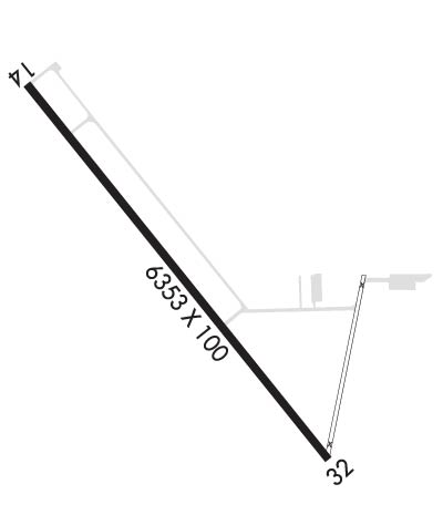
| Lat: N 4127.0 Long: W 09631.3 Elev: 1204 Var: -03 Longest Runway: 6353 | ||
| AWOS: 121.27 CTAF: 122.8 | ||
| |||||||||||||||||||||||||||||||||||||||||||||||||||||||||||||
| |||||||||||||||||||||||||||||||||||||||||||||||||||||||||||||
| |||||||||||||||||||||||||||||||||||||||||||||||||||||||||||||
| Rwy | Rwy | |||||||
| 6353x100 | 5503' | 6353x100 | 5503' | |||||
| Runway ID | Single Wheel | Double Wheel | Double Tandem Wheel | Dual Double Wheel |
| 14/32 | 28,000 | 48,000 | N/A | N/A |
| These numbers are Advisory and are not limits. The Airport Manager should have more accurate Weight Limits | ||||
 Airport Diagram might not be current. | |
| Facility Name: | FREMONT MUNI |
| City Name: | FREMONT |
| County: | DODGE |
| State abbrev: | NE |
| State Name: | NEBRASKA |
| Ownership: | PUBLICLY OWNED |
| Use: | OPEN TO THE PUBLIC |
| Owner's Name: | CITY OF FREMONT; JODY SANDERS, CITY ADMINISTRATOR |
| Address: | 400 EAST MILITARY AVENUE |
| FREMONT, NE 68025-5141 | |
| Owner's Phone: | 402-727-2630 |
| Manager's Name: | CARI HOFFART; CARI HOFFART, AIRPORT MANAGER & DAN GILLIS, PUBLIC WORKS DIRECTOR |
| Address: | 97 WEST 3RD STREET |
| FREMONT, NE 68025-4945 | |
| Phone: | 402-727-2691 |
| FAA Region: | CENTRAL |
| FAA Field Office: | NONE |

| Date | Sunrise | Sunset |
|---|---|---|
| 06/08/26 Monday | 5:52 | 20:58 |
| 06/09/26 Tuesday | 5:52 | 20:59 |
| 06/10/26 Wednesday | 5:52 | 20:59 |
| 06/11/26 Thursday | 5:52 | 21:00 |
| 06/12/26 Friday | 5:52 | 21:00 |
| 06/13/26 Saturday | 5:52 | 21:01 |
| 06/14/26 Sunday | 5:52 | 21:01 |
| 06/15/26 Monday | 5:52 | 21:01 |
| 06/16/26 Tuesday | 5:52 | 21:02 |
| 06/17/26 Wednesday | 5:52 | 21:02 |
| 06/18/26 Thursday | 5:52 | 21:02 |
| 06/19/26 Friday | 5:52 | 21:03 |
| 06/20/26 Saturday | 5:52 | 21:03 |
| 06/21/26 Sunday | 5:52 | 21:03 |
| Airport Attendance Schedule | 7 Days A Week 0700-2000; FOR ATTENDANT AFT HRS CALL (402) 727-4665/(402) 719-9364 OR (402) 720-2863. |
| Airport Status | OPERATIONAL (This Status can change at any time - please check NOTAMS) |
| Airport Lighting Schedule | ACTVT REIL RY 14 & PAPI RYS 14 & 32 - CTAF. |
| Airport Storage Available | Tie Downs |
| Extra Services Available | Flight Instruction, Aircraft Rental |
| Wind Indicator | YES - (lighted) |
| Control Tower | NO |
| CTAF Frequency | 122.800 |
| Unicom Frequency | 122.800 |
| Rotating Beacon Color | WG |
| Segmented Circle | YES |
| Landing Fee | NO |
| Airport Inspected | STATE - performed by STATE AERONAUTICAL PERSONNEL |
| Inspection Date | 08/17/2023 |
| Type of Fuel Available | Grade 100LL, JET A (freeze point -40C) |
| Airframe Repair Service | MAJOR |
| Power Plant Repair Service | MAJOR |
| Latitude | N4127.0 |
| Longitude | W09631.3 (ESTIMATED) |
| Arpt Elevation | 1204ft (SURVEYED) |
| Magnetic Variation | 03E |
| 2 miles NW | of FREMONT |
| Traffic Pattern Altitude | |
| Sectional Chart | OMAHA |
| Operations (Reported) | Yearly | Avg. Daily |
|---|---|---|
| General Aviation Transient | 0 | 0 |
| General Aviation Local | 0 | 0 |
| Air Taxi | 0 | 0 |
| Commerical | 0 | 0 |
| Commuter | 0 | 0 |
| Military | 0 | 0 |
| Aircraft based on Field | |
|---|---|
| General Aviation Singles | 0 |
| General Aviation Multi | 0 |
| Jet Aircraft | 0 |
| General Aviation Helicopters | 0 |
| Military Aircraft | 0 |
| Gliders | 0 |
| Ultralights | 0 |
| FSS on field | NO |
| FSS tie-in | COLUMBUS |
| FSS Phone | 1-800-WX-BRIEF |
| Who issues Notams | FET |
| Notam D service at airport | YES |
| ARTCC Name | MINNEAPOLIS |
| Airport Certification | |
| Aircraft Rescue & Firefighting Index | None |
| Airport of Entry | No |
| Custom Landing Rights | No |
| Joint Civil/Military | No |
| Military Landing rights | No |
| NATIONAL PLAN OF INTEGRATED AIRPORT SYSTEMS (NPIAS) |
| GRANT AGREEMENTS UNDER FAAP/ADAP/AIP |
| ASSURANCES PURSUANT TO TITLE VI, CIVIL RIGHTS ACT OF 1964 |
| (E81) TURN OFF ONLY. |
| FOR CD CTC OMAHA APCH AT 402-682-4395. |
| FORMER RWY 1/19 IN USE AS TWY ONLY. |
| RWY 14/3 2 RWY 14 PVMNT SOUTH OF DSP THR PCI RATED POOR FOR 2300 FT. |
Airport Communications & Frequencies:
| ||||||||||||||
| Runway: 14 | Runway: 32 | ||
| Mag heading: | 138° | Mag heading: | 318° |
| Rwy Slope: | .00% Down | Rwy Slope: | .00% Up |
| Approach: | Approach: | ||
| Pattern: | Left Traffic | Pattern: | Right Traffic |
| Markings: | NONPRECISION INSTRUMENT | Markings: | NONPRECISION INSTRUMENT |
| Marking Condition: | GOOD | Marking Condition: | GOOD |
| Arresting Dev: | Arresting Dev: | ||
| Lat & Long: | N4127.5 W09631.8 | Lat. & Long.: | N4126.6 W09631.0 |
| Elev: | 1203.0 ft. MSL | Elev: | 1202.7 ft. MSL |
| TCH: | 40 ft. AGL | TCH: | 40 ft. AGL |
| Visual Glide Path: | 3.00 degrees | Visual Glide Path: | 3.00 degrees |
| Displaced Threshold: | 850 feet | Displaced Threshold: | 850 feet |
| Touchdown Zone: | YES | Touchdown Zone: | YES |
| Touchdown Elev.: | 1203.6 feet | Touchdown Elev.: | 1204.0 feet |
| Visual Glide Slope: | 2-Light PAPI on LEFT side of Runway | Visual Glide Slope: | 2-Light PAPI on LEFT side of Runway; PAPI LGT OTS INDEF. |
| RVR Equipment: | RVR Equipment: | ||
| RVV Equipment: | NO | RVV Equipment: | NO |
| Approach Lights: | Approach Lights: | ||
| REIL: | YES | REIL: | NO |
| Centerline Lights: | NO | Centerline Lights: | NO |
| Touchdown lights: | NO | Touchdown lights: | NO |
| Runway Category: | Runway with a Non-precision Approach having visibility minimums greater than 3/4 mile | Runway Category: | Runway with a Non-precision Approach having visibility minimums greater than 3/4 mile |
| Declared Distances: | TORA:5500' TODA:5500' ASDA:5500' LDA:4650' | Declared Distances: | TORA:5500' TODA:5500' ASDA:5500' LDA:4650' |
| Obstructions: | POLE | Obstructions: | TREE |
| Marked: | NOT Marked/Lighted | Marked: | NOT Marked/Lighted |
| Clearance slope: | 7:1; APCH SLP 43:1 TO DTHR OVR +29 FT LIGHT POLE, 1272 FT DIST. | Clearance slope: | 11:1; APCH SLP 30:1 TO DTHR OVR +66 FT TREE, 2017 FT DIST 309 L & +51 FT TREE, 1521 FT DIST, 405 L. |
| Obstruction height: | 29 feet AGL | Obstruction height: | 54 feet AGL |
| Dist. from runway: | 422 feet | Dist. from runway: | 795 feet |
| Centerline offset: | 93 right of centerline | Centerline offset: | 243 feet left of centerline |
| Comments: | Comments: |
Thanks for using FltPlan.com
all rights reserved © 1999-2026 by Flight Plan LLC