
| FESTUS MEMORIAL FESTUS MO |
| |
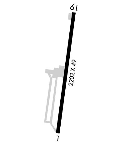
| Lat: N 3811.7 Long: W 09023.1 Elev: 433 Var: +02 Longest Runway: 2202 | ||
| CTAF: 122.7 | ||
| ||||||||||||||||||||||||||||||||||||||||||||
| ||||||||||||||||||||||||||||||||||||||||||||
| Rwy | Rwy | |||||||
| 2202x49 | 2202' | 2202x49 | 2202' | |||||
| Runway ID | Single Wheel | Double Wheel | Double Tandem Wheel | Dual Double Wheel |
| 01/19 | 8,000 | N/A | N/A | N/A |
| These numbers are Advisory and are not limits. The Airport Manager should have more accurate Weight Limits | ||||
 Airport Diagram might not be current. | |
| Facility Name: | FESTUS MEML |
| City Name: | FESTUS |
| County: | JEFFERSON |
| State abbrev: | MO |
| State Name: | MISSOURI |
| Ownership: | PRIVATELY OWNED |
| Use: | OPEN TO THE PUBLIC |
| Owner's Name: | JEFFCO PORT DEVELOPMENT, INC. |
| Address: | 900 AIRPORT ROAD |
| FESTUS, MO 63028 | |
| Owner's Phone: | 636-937-2228 |
| Manager's Name: | JODY MOORE |
| Address: | 900 ARPT RD |
| FESTUS, MO 63028 | |
| Phone: | 636-937-2228 |
| FAA Region: | CENTRAL |
| FAA Field Office: | NONE |
| Date | Sunrise | Sunset |
|---|---|---|
| 09/24/21 Friday | 6:51 | 18:56 |
| 09/25/21 Saturday | 6:52 | 18:54 |
| 09/26/21 Sunday | 6:53 | 18:53 |
| 09/27/21 Monday | 6:53 | 18:51 |
| 09/28/21 Tuesday | 6:54 | 18:49 |
| 09/29/21 Wednesday | 6:55 | 18:48 |
| 09/30/21 Thursday | 6:56 | 18:46 |
| 10/01/21 Friday | 6:57 | 18:45 |
| 10/02/21 Saturday | 6:58 | 18:43 |
| 10/03/21 Sunday | 6:59 | 18:42 |
| 10/04/21 Monday | 7:00 | 18:40 |
| 10/05/21 Tuesday | 7:01 | 18:39 |
| 10/06/21 Wednesday | 7:02 | 18:37 |
| 10/07/21 Thursday | 7:03 | 18:36 |
| Airport Attendance Schedule | 7 Days A Week 0800-1600 |
| Airport Status | OPERATIONAL (This Status can change at any time - please check NOTAMS) |
| Airport Lighting Schedule | ACTVT MIRL RY 01/19 - CTAF |
| Airport Storage Available | Tie Downs, Hanger |
| Extra Services Available | Flight Instruction, Aircraft Rental |
| Wind Indicator | YES - (lighted) |
| Control Tower | NO |
| CTAF Frequency | 122.700 |
| Unicom Frequency | 122.700 |
| Rotating Beacon Color | CLEAR-GREEN (Light Land Airport) |
| Segmented Circle | NO |
| Landing Fee | NO |
| Airport Inspected | STATE - performed by STATE AERONAUTICAL PERSONNEL |
| Inspection Date | 07/15/2020 |
| Type of Fuel Available | Grade 100LL, JET A (freeze point -40C); -10CALL NUMBER ON OFFICE DOOR FOR FUEL |
| Airframe Repair Service | MAJOR |
| Power Plant Repair Service | MAJOR |
| Latitude | N3811.7 |
| Longitude | W09023.1 (ESTIMATED) |
| Arpt Elevation | 433ft (SURVEYED) |
| Magnetic Variation | 02W |
| 2 miles S | of FESTUS |
| Traffic Pattern Altitude | |
| Sectional Chart | ST LOUIS |
| Operations (Reported) | Yearly | Avg. Daily |
|---|---|---|
| General Aviation Transient | 3000 | 8 |
| General Aviation Local | 6000 | 16 |
| Air Taxi | 0 | 0 |
| Commerical | 0 | 0 |
| Commuter | 0 | 0 |
| Military | 6 | 0 |
| Aircraft based on Field | |
|---|---|
| General Aviation Singles | 24 |
| General Aviation Multi | 1 |
| Jet Aircraft | 0 |
| General Aviation Helicopters | 0 |
| Military Aircraft | 0 |
| Gliders | 0 |
| Ultralights | 0 |
| FSS on field | NO |
| FSS tie-in | SAINT LOUIS |
| FSS Phone | 1-800-WX-BRIEF |
| Who issues Notams | STL |
| Notam D service at airport | YES |
| ARTCC Name | KANSAS CITY |
| Airport Certification | |
| Aircraft Rescue & Firefighting Index | None |
| Airport of Entry | No |
| Custom Landing Rights | No |
| Joint Civil/Military | No |
| Military Landing rights | YES |
| ASSURANCES PURSUANT TO TITLE VI, CIVIL RIGHTS ACT OF 1964 |
| GRANT AGREEMENT HAS EXPIRED; HOWEVER, AGREEMENT REMAINS IN EFFECT FOR THIS FACILITY AS LONG AS IT IS PUBLIC USE. |
| THIS AIRPORT HAS BEEN SURVEYED BY THE NATIONAL GEODETIC SURVEY. |
| NTSD RY SAFETY AREA BYND EACH RY END; RY 01 HAS ROLLING & STEEP TERRAIN; RY 19 HAS LARGE DROP OFF 118 FT FM RY END. |
| FOR CD CTC ST LOUIS APCH AT 314-890-1017. |
Airport Communications & Frequencies:
| ||||||||||||||
| Runway: 01 | Runway: 19 | ||
| Mag heading: | 10° | Mag heading: | 190° |
| Rwy Slope: | .09% Up | Rwy Slope: | -.09% Down |
| Approach: | Approach: | ||
| Pattern: | Left Traffic | Pattern: | Left Traffic |
| Markings: | BASIC | Markings: | BASIC |
| Marking Condition: | GOOD; NSTD BASIC MARKINGS; INCORRECT RY DESIGNATOR AND SPACING OF MARKINGS. | Marking Condition: | GOOD; NSTD BASIC MARKINGS; INCORRECT SPACING OF MARKINGS. |
| Arresting Dev: | Arresting Dev: | ||
| Lat & Long: | N3811.5 W09023.2 | Lat. & Long.: | N3811.9 W09023.1 |
| Elev: | 430.0 ft. MSL | Elev: | 432.0 ft. MSL |
| TCH: | TCH: | ||
| Visual Glide Path: | Visual Glide Path: | ||
| Displaced Threshold: | No | Displaced Threshold: | No |
| Touchdown Zone: | YES | Touchdown Zone: | YES |
| Touchdown Elev.: | 432.0 feet | Touchdown Elev.: | 432.0 feet |
| Visual Glide Slope: | 2-BOX SIMPLIFIED ABBREVIATED VISUAL APPROACH SLOPE INDICATOR ON LEFT SIDE OF RUNWAY; VASI OTS INDEFLY. | Visual Glide Slope: | |
| RVR Equipment: | RVR Equipment: | ||
| RVV Equipment: | NO | RVV Equipment: | NO |
| Approach Lights: | Approach Lights: | ||
| REIL: | NO | REIL: | NO |
| Centerline Lights: | NO | Centerline Lights: | NO |
| Touchdown lights: | NO | Touchdown lights: | NO |
| Runway Category: | Runway with a Non-precision Approach | Runway Category: | Runway with a Visual Approach |
| Declared Distances: | Declared Distances: | ||
| Obstructions: | TREES | Obstructions: | TREES |
| Marked: | NOT Marked/Lighted | Marked: | NOT Marked/Lighted |
| Clearance slope: | 3:1 | Clearance slope: | 1:1 |
| Obstruction height: | 31 feet AGL | Obstruction height: | 24 feet AGL |
| Dist. from runway: | 320 feet | Dist. from runway: | 230 feet |
| Centerline offset: | 130 right of centerline | Centerline offset: | 250 feet right of centerline |
| Comments: | 1-20 FT BRUSH & TREES 0-35FT FM RY END 190-250 FT R.; +1-12 FT BRUSH, 0-200 FT FM RY END, 65-200 FT L. | Comments: | 1-28 FT TREES; BRUSH & ROAD 0-200 FT FM RY END 185-200 FT L; 1- 45 FT TREES & BRUSH 0-200 FT FM RY END 133-250 FT R. |
Thanks for using FltPlan.com
all rights reserved © 1999-2021 by Flight Plan LLC
