
| FINDLAY FINDLAY OH |
| |
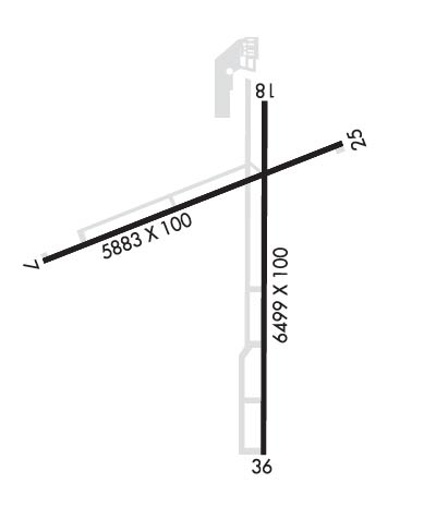
| Lat: N 4100.7 Long: W 08340.1 Elev: 813 Var: +05 Longest Runway: 6499 | ||
| AWOS: 132.85 CTAF: 122.72 | ||
| ||||||||||||||||||||||||||||||||||||||||||||
| ||||||||||||||||||||||||||||||||||||||||||||
| ||||||||||||||||||||||||||||||||||||||||||||
| Rwy | Rwy | |||||||
| 5883x100 | 5559' | 5883x100 | 4884' | |||||
| 6499x100 | 6499' | 6499x100 | 6499' | |||||
| Runway ID | Single Wheel | Double Wheel | Double Tandem Wheel | Dual Double Wheel |
| 07/25 | 100,000 | 160,000 | 280,000 | N/A |
| 18/36 | 100,000 | 160,000 | 280,000 | N/A |
| These numbers are Advisory and are not limits. The Airport Manager should have more accurate Weight Limits | ||||
 Airport Diagram might not be current. | |
| Facility Name: | FINDLAY |
| City Name: | FINDLAY |
| County: | HANCOCK |
| State abbrev: | OH |
| State Name: | OHIO |
| Ownership: | PUBLICLY OWNED |
| Use: | OPEN TO THE PUBLIC |
| Owner's Name: | CITY OF FINDLAY |
| Address: | 310 MUNICIPAL BLDG |
| FINDLAY, OH 45840-3346 | |
| Owner's Phone: | 419-424-7137 |
| Manager's Name: | MATT MCVICKER; AIRPORT@FINDLAYOHIO.COM. |
| Address: | 1615 GRAY ST |
| FINDLAY, OH 45840-1411 | |
| Phone: | 419-422-4182 |
| FAA Region: | GREAT LAKES |
| FAA Field Office: | DET |
| Date | Sunrise | Sunset |
|---|---|---|
| 09/24/21 Friday | 7:24 | 19:29 |
| 09/25/21 Saturday | 7:25 | 19:27 |
| 09/26/21 Sunday | 7:26 | 19:25 |
| 09/27/21 Monday | 7:27 | 19:24 |
| 09/28/21 Tuesday | 7:28 | 19:22 |
| 09/29/21 Wednesday | 7:29 | 19:20 |
| 09/30/21 Thursday | 7:30 | 19:19 |
| 10/01/21 Friday | 7:31 | 19:17 |
| 10/02/21 Saturday | 7:32 | 19:15 |
| 10/03/21 Sunday | 7:33 | 19:14 |
| 10/04/21 Monday | 7:34 | 19:12 |
| 10/05/21 Tuesday | 7:35 | 19:10 |
| 10/06/21 Wednesday | 7:36 | 19:09 |
| 10/07/21 Thursday | 7:37 | 19:07 |
| Airport Attendance Schedule | MON-FRI 0700-1800, SAT-SUN 0900-1700 |
| Airport Status | OPERATIONAL (This Status can change at any time - please check NOTAMS) |
| Airport Lighting Schedule | ACTVT REIL RWY 07, 25, & 36; HIRL RWY 07/25 & 18/36 - CTAF. PAPI RWY 07, 25, 18, & 36 OPR CONSLY. |
| Airport Storage Available | Tie Downs, Hanger |
| Extra Services Available | NONE |
| Wind Indicator | YES - (lighted) |
| Control Tower | NO |
| CTAF Frequency | 122.725 |
| Unicom Frequency | 122.725 |
| Rotating Beacon Color | CLEAR-GREEN (Light Land Airport) |
| Segmented Circle | NO |
| Landing Fee | NO |
| Airport Inspected | STATE - performed by PRIVATE CONTRACT PERSONNEL |
| Inspection Date | 07/15/2021 |
| Type of Fuel Available | Grade 100LL, JET A |
| Airframe Repair Service | None |
| Power Plant Repair Service | None |
| Latitude | N4100.7 |
| Longitude | W08340.1 (ESTIMATED) |
| Arpt Elevation | 812ft (SURVEYED) |
| Magnetic Variation | 05W |
| 1 miles SW | of FINDLAY |
| Traffic Pattern Altitude | |
| Sectional Chart | DETROIT |
| Operations (Reported) | Yearly | Avg. Daily |
|---|---|---|
| General Aviation Transient | 12000 | 33 |
| General Aviation Local | 12000 | 33 |
| Air Taxi | 500 | 1 |
| Commerical | 0 | 0 |
| Commuter | 0 | 0 |
| Military | 50 | 0 |
| Aircraft based on Field | |
|---|---|
| General Aviation Singles | 14 |
| General Aviation Multi | 0 |
| Jet Aircraft | 6 |
| General Aviation Helicopters | 0 |
| Military Aircraft | 0 |
| Gliders | 0 |
| Ultralights | 0 |
| FSS on field | NO |
| FSS tie-in | CLEVELAND |
| FSS Phone | 1-800-WX-BRIEF |
| Who issues Notams | FDY |
| Notam D service at airport | YES |
| ARTCC Name | CLEVELAND |
| Airport Certification | |
| Aircraft Rescue & Firefighting Index | None |
| Airport of Entry | No |
| Custom Landing Rights | No |
| Joint Civil/Military | No |
| Military Landing rights | No |
| NATIONAL PLAN OF INTEGRATED AIRPORT SYSTEMS (NPIAS) |
| FOR CD IF UNA TO CTC ON FSS FREQ, CTC CLEVELAND ARTCC AT 440-774-0490. |
Airport Communications & Frequencies:
| ||||||||||||||
| Runway: 07 | Runway: 25 | ||
| Mag heading: | 74° | Mag heading: | 254° |
| Rwy Slope: | .21% Up | Rwy Slope: | -.21% Down |
| Approach: | Approach: | ||
| Pattern: | Left Traffic | Pattern: | Left Traffic |
| Markings: | NONPRECISION INSTRUMENT | Markings: | NONPRECISION INSTRUMENT |
| Marking Condition: | GOOD | Marking Condition: | GOOD |
| Arresting Dev: | Arresting Dev: | ||
| Lat & Long: | N4100.7 W08340.9 | Lat. & Long.: | N4101.0 W08339.7 |
| Elev: | 793.7 ft. MSL | Elev: | 805.8 ft. MSL |
| TCH: | 24 ft. AGL | TCH: | 31 ft. AGL |
| Visual Glide Path: | 3.00 degrees | Visual Glide Path: | 3.00 degrees |
| Displaced Threshold: | 324 feet | Displaced Threshold: | 999 feet |
| Touchdown Zone: | YES | Touchdown Zone: | YES |
| Touchdown Elev.: | 809.5 feet | Touchdown Elev.: | 812.4 feet |
| Visual Glide Slope: | 4-Light PAPI on LEFT side of Runway | Visual Glide Slope: | 4-Light PAPI on LEFT side of Runway |
| RVR Equipment: | RVR Equipment: | ||
| RVV Equipment: | NO | RVV Equipment: | NO |
| Approach Lights: | Approach Lights: | ||
| REIL: | YES | REIL: | YES |
| Centerline Lights: | NO | Centerline Lights: | NO |
| Touchdown lights: | NO | Touchdown lights: | NO |
| Runway Category: | Runway with a Non-precision Approach having visibility minimums greater than 3/4 mile | Runway Category: | Runway with a Non-precision Approach having visibility minimums greater than 3/4 mile |
| Declared Distances: | TORA:5251' TODA:5251' ASDA:4881' LDA:4558' | Declared Distances: | TORA:5786' TODA:5786' ASDA:5558' LDA:4558' |
| Obstructions: | TREES | Obstructions: | ROAD |
| Marked: | NOT Marked/Lighted | Marked: | NOT Marked/Lighted |
| Clearance slope: | 28:1; APCH SLP 15:1 TO DTHR OVR 70 FT TREES, 1100 FT DIST, 415 FT L. | Clearance slope: | |
| Obstruction height: | 70 feet AGL | Obstruction height: | 21 feet AGL |
| Dist. from runway: | 2200 feet | Dist. from runway: | 201 feet |
| Centerline offset: | 270 left of centerline | Centerline offset: | |
| Comments: | Comments: | 12 FT L/M BLAST FENCE, 117 FT DIST; 18 FT ROAD, 110 FT DIST. |
| Runway: 18 | Runway: 36 | ||
| Mag heading: | 185° | Mag heading: | 5° |
| Rwy Slope: | -.02% Down | Rwy Slope: | .02% Up |
| Approach: | Approach: | ||
| Pattern: | Left Traffic | Pattern: | Left Traffic |
| Markings: | NONPRECISION INSTRUMENT | Markings: | NONPRECISION INSTRUMENT |
| Marking Condition: | GOOD | Marking Condition: | GOOD |
| Arresting Dev: | Arresting Dev: | ||
| Lat & Long: | N4101.1 W08340.0 | Lat. & Long.: | N4100.1 W08340.0 |
| Elev: | 804.5 ft. MSL | Elev: | 803.2 ft. MSL |
| TCH: | 43 ft. AGL | TCH: | 50 ft. AGL |
| Visual Glide Path: | 3.00 degrees | Visual Glide Path: | 3.00 degrees |
| Displaced Threshold: | No | Displaced Threshold: | No |
| Touchdown Zone: | YES | Touchdown Zone: | YES |
| Touchdown Elev.: | 812.8 feet | Touchdown Elev.: | 808.5 feet |
| Visual Glide Slope: | 4-Light PAPI on LEFT side of Runway | Visual Glide Slope: | 4-Light PAPI on LEFT side of Runway |
| RVR Equipment: | RVR Equipment: | ||
| RVV Equipment: | NO | RVV Equipment: | NO |
| Approach Lights: | Approach Lights: | ||
| REIL: | NO | REIL: | YES |
| Centerline Lights: | NO | Centerline Lights: | NO |
| Touchdown lights: | NO | Touchdown lights: | NO |
| Runway Category: | Runway with a Non-precision Approach having visibility minimums greater than 3/4 mile | Runway Category: | Runway with a Non-precision Approach having visibility minimums greater than 3/4 mile |
| Declared Distances: | Declared Distances: | ||
| Obstructions: | PLINE | Obstructions: | TREES |
| Marked: | NOT Marked/Lighted | Marked: | NOT Marked/Lighted |
| Clearance slope: | 31:1; APCH RATIO 33:1 TO DTHR. | Clearance slope: | 31:1 |
| Obstruction height: | 60 feet AGL | Obstruction height: | 80 feet AGL |
| Dist. from runway: | 2100 feet | Dist. from runway: | 2650 feet |
| Centerline offset: | 540 right of centerline | Centerline offset: | |
| Comments: | Comments: |
Thanks for using FltPlan.com
all rights reserved © 1999-2021 by Flight Plan LLC
