
| FREDERICK RGNL FREDERICK OK |
| |
| Lat: N 3421.1 Long: W 09859.0 Elev: 1258 Var: -07 Longest Runway: 6099 | ||
| AWOS: 132.67 CTAF: 123.05 | ||
| ||||||
| ||||||
|
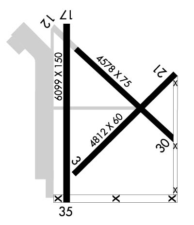
| Rwy | Rwy | |||||||
| 4812x60 | 4812' | 4812x60 | 4812' | |||||
| 4578x75 | 4578' | 4578x75 | 4578' | |||||
| 6099x150 | 6099' | 6099x150 | 6099' | |||||
| Runway ID | Single Wheel | Double Wheel | Double Tandem Wheel | Dual Double Wheel |
| 03/21 | 30,000 | N/A | N/A | N/A |
| 12/30 | 30,000 | N/A | N/A | N/A |
| 17/35 | 35,000 | 50,000 | 100,000 | N/A |
| These numbers are Advisory and are not limits. The Airport Manager should have more accurate Weight Limits | ||||
 Airport Diagram might not be current. | |
| Facility Name: | FREDERICK RGNL |
| City Name: | FREDERICK |
| County: | TILLMAN |
| State abbrev: | OK |
| State Name: | OKLAHOMA |
| Ownership: | PUBLICLY OWNED |
| Use: | OPEN TO THE PUBLIC |
| Owner's Name: | CITY OF FREDERICK |
| Address: | CITY HALL PO BOX 399 |
| FREDERICK, OK 73542 | |
| Owner's Phone: | 580-335-7551 |
| Manager's Name: | JIMMY GAITHER |
| Address: | CITY HALL PO BOX 399 |
| FREDERICK, OK 73542 | |
| Phone: | 580-335-2421 |
| FAA Region: | SOUTHWEST |
| FAA Field Office: | AOK |
| Date | Sunrise | Sunset |
|---|---|---|
| 06/08/26 Monday | 6:23 | 20:47 |
| 06/09/26 Tuesday | 6:23 | 20:47 |
| 06/10/26 Wednesday | 6:23 | 20:48 |
| 06/11/26 Thursday | 6:23 | 20:48 |
| 06/12/26 Friday | 6:23 | 20:48 |
| 06/13/26 Saturday | 6:23 | 20:49 |
| 06/14/26 Sunday | 6:23 | 20:49 |
| 06/15/26 Monday | 6:23 | 20:50 |
| 06/16/26 Tuesday | 6:23 | 20:50 |
| 06/17/26 Wednesday | 6:23 | 20:50 |
| 06/18/26 Thursday | 6:24 | 20:51 |
| 06/19/26 Friday | 6:24 | 20:51 |
| 06/20/26 Saturday | 6:24 | 20:51 |
| 06/21/26 Sunday | 6:24 | 20:51 |
| Airport Attendance Schedule | MON-SAT 0800-1700, SUN 1300-1700 |
| Airport Status | OPERATIONAL (This Status can change at any time - please check NOTAMS) |
| Airport Lighting Schedule | ACTVT MIRL RWY 17/35 - CTAF. PAPI RWY 17 & 35 ON CONSLY. |
| Airport Storage Available | Tie Downs |
| Extra Services Available | Crop Dusting |
| Wind Indicator | YES - (lighted) |
| Control Tower | NO |
| CTAF Frequency | 123.050 |
| Unicom Frequency | 123.050 |
| Rotating Beacon Color | WG |
| Segmented Circle | YES |
| Landing Fee | NO |
| Airport Inspected | STATE - performed by STATE AERONAUTICAL PERSONNEL |
| Inspection Date | 07/31/2024 |
| Type of Fuel Available | Grade 100LL; -10SELF SER FUEL AVBL 24 HRS, FOR ASSISTANCE CALL 580-335-1948. |
| Airframe Repair Service | NONE |
| Power Plant Repair Service | NONE |
| Latitude | N3421.1 |
| Longitude | W09859.0 (ESTIMATED) |
| Arpt Elevation | 1258ft (SURVEYED) |
| Magnetic Variation | 07E |
| 3 miles SE | of FREDERICK |
| Traffic Pattern Altitude | |
| Sectional Chart | DALLAS-FT WORTH |
| Operations (Reported) | Yearly | Avg. Daily |
|---|---|---|
| General Aviation Transient | 0 | 0 |
| General Aviation Local | 0 | 0 |
| Air Taxi | 0 | 0 |
| Commerical | 0 | 0 |
| Commuter | 0 | 0 |
| Military | 0 | 0 |
| Aircraft based on Field | |
|---|---|
| General Aviation Singles | 0 |
| General Aviation Multi | 0 |
| Jet Aircraft | 0 |
| General Aviation Helicopters | 0 |
| Military Aircraft | 0 |
| Gliders | 0 |
| Ultralights | 0 |
| FSS on field | NO |
| FSS tie-in | MC ALESTER |
| FSS Phone | 1-800-WX-BRIEF |
| Who issues Notams | FDR |
| Notam D service at airport | YES |
| ARTCC Name | FORT WORTH |
| Airport Certification | |
| Aircraft Rescue & Firefighting Index | None |
| Airport of Entry | No |
| Custom Landing Rights | No |
| Joint Civil/Military | No |
| Military Landing rights | YES |
| NATIONAL PLAN OF INTEGRATED AIRPORT SYSTEMS (NPIAS) |
| GRANT AGREEMENTS UNDER FAAP/ADAP/AIP |
| SURPLUS PROPERTY AGREEMENT UNDER PUBLIC LAW 289 |
| SURPLUS PROPERTY AGREEMENT UNDER REGULATION 16-WAA |
| ASSURANCES PURSUANT TO TITLE VI, CIVIL RIGHTS ACT OF 1964 |
| ARPT USED AS SHEPPARD AFB AUX. MIL TFC DALGT MON-FRI; CTC UNICOM FOR ADZY. |
| MIL TFC ONLY WL USE RIGHT 360 DEG OVERHEAD APCHS TO RY 17. |
| FOR CD CTC FORT WORTH ARTCC AT 817-858-7584. |
| RWY 03/2 1 MKD TO 60 FT WIDE; PAVEMENT 150 FT WIDE. |
| RWY 12/3 0 RY MKD TO 75 FT WIDE; PAVEMENT 150 FT WIDE. |
| RWY 03/2 1 MODERATE CRACKING AND DETERIORATION. |
| RWY 12/3 0 MODERATE CRACKING AND DETERIORATION. |
Airport Communications & Frequencies:
| |||||||||||||||||
| Runway: 03 | Runway: 21 | ||
| Mag heading: | 38° | Mag heading: | 218° |
| Rwy Slope: | .29% Up | Rwy Slope: | -.29% Down |
| Approach: | Approach: | ||
| Pattern: | Left Traffic | Pattern: | Left Traffic |
| Markings: | BASIC | Markings: | BASIC |
| Marking Condition: | FAIR | Marking Condition: | FAIR |
| Arresting Dev: | Arresting Dev: | ||
| Lat & Long: | N3420.8 W09859.3 | Lat. & Long.: | N3421.3 W09858.6 |
| Elev: | 1239.2 ft. MSL | Elev: | 1253.0 ft. MSL |
| TCH: | TCH: | ||
| Visual Glide Path: | Visual Glide Path: | ||
| Displaced Threshold: | No | Displaced Threshold: | No |
| Touchdown Zone: | YES | Touchdown Zone: | YES |
| Touchdown Elev.: | 1248.3 feet | Touchdown Elev.: | 1253.0 feet |
| Visual Glide Slope: | Visual Glide Slope: | ||
| RVR Equipment: | RVR Equipment: | ||
| RVV Equipment: | NO | RVV Equipment: | NO |
| Approach Lights: | Approach Lights: | ||
| REIL: | NO | REIL: | NO |
| Centerline Lights: | NO | Centerline Lights: | NO |
| Touchdown lights: | NO | Touchdown lights: | NO |
| Runway Category: | Runway with a Visual Approach | Runway Category: | Runway with a Visual Approach |
| Declared Distances: | Declared Distances: | ||
| Obstructions: | Obstructions: | ROAD | |
| Marked: | Marked: | NOT Marked/Lighted | |
| Clearance slope: | 20:1 | Clearance slope: | 10:1 |
| Obstruction height: | Obstruction height: | 15 feet AGL | |
| Dist. from runway: | Dist. from runway: | 350 feet | |
| Centerline offset: | Centerline offset: | 250 feet left of centerline | |
| Comments: | Comments: |
| Runway: 12 | Runway: 30 | ||
| Mag heading: | 128° | Mag heading: | 308° |
| Rwy Slope: | -.27% Down | Rwy Slope: | .27% Up |
| Approach: | Approach: | ||
| Pattern: | Left Traffic | Pattern: | Left Traffic |
| Markings: | BASIC | Markings: | BASIC |
| Marking Condition: | FAIR | Marking Condition: | FAIR |
| Arresting Dev: | Arresting Dev: | ||
| Lat & Long: | N3421.5 W09859.3 | Lat. & Long.: | N3421.0 W09858.6 |
| Elev: | 1255.9 ft. MSL | Elev: | 1243.5 ft. MSL |
| TCH: | TCH: | ||
| Visual Glide Path: | Visual Glide Path: | ||
| Displaced Threshold: | No | Displaced Threshold: | No |
| Touchdown Zone: | YES | Touchdown Zone: | YES |
| Touchdown Elev.: | 1258.0 feet | Touchdown Elev.: | 1255.3 feet |
| Visual Glide Slope: | Visual Glide Slope: | ||
| RVR Equipment: | RVR Equipment: | ||
| RVV Equipment: | NO | RVV Equipment: | NO |
| Approach Lights: | Approach Lights: | ||
| REIL: | NO | REIL: | NO |
| Centerline Lights: | NO | Centerline Lights: | NO |
| Touchdown lights: | NO | Touchdown lights: | NO |
| Runway Category: | Runway with a Visual Approach | Runway Category: | Runway with a Visual Approach |
| Declared Distances: | Declared Distances: | ||
| Obstructions: | Obstructions: | ROAD | |
| Marked: | Marked: | NOT Marked/Lighted | |
| Clearance slope: | 20:1 | Clearance slope: | 11:1 |
| Obstruction height: | Obstruction height: | 13 feet AGL | |
| Dist. from runway: | Dist. from runway: | 350 feet | |
| Centerline offset: | Centerline offset: | 250 feet right of centerline | |
| Comments: | Comments: |
| Runway: 17 | Runway: 35 | ||
| Mag heading: | 173° | Mag heading: | 353° |
| Rwy Slope: | -.30% Down | Rwy Slope: | .30% Up |
| Approach: | Approach: | ||
| Pattern: | Left Traffic | Pattern: | Left Traffic |
| Markings: | NONPRECISION INSTRUMENT | Markings: | NONPRECISION INSTRUMENT |
| Marking Condition: | GOOD | Marking Condition: | GOOD |
| Arresting Dev: | Arresting Dev: | ||
| Lat & Long: | N3421.6 W09859.4 | Lat. & Long.: | N3420.6 W09859.4 |
| Elev: | 1254.3 ft. MSL | Elev: | 1236.1 ft. MSL |
| TCH: | 40 ft. AGL | TCH: | 40 ft. AGL |
| Visual Glide Path: | 3.00 degrees | Visual Glide Path: | 3.00 degrees |
| Displaced Threshold: | No | Displaced Threshold: | No |
| Touchdown Zone: | YES | Touchdown Zone: | YES |
| Touchdown Elev.: | 1254.3 feet | Touchdown Elev.: | 1237.9 feet |
| Visual Glide Slope: | 4-Light PAPI on LEFT side of Runway | Visual Glide Slope: | 4-Light PAPI on LEFT side of Runway |
| RVR Equipment: | RVR Equipment: | ||
| RVV Equipment: | NO | RVV Equipment: | NO |
| Approach Lights: | Approach Lights: | ||
| REIL: | NO | REIL: | YES |
| Centerline Lights: | NO | Centerline Lights: | NO |
| Touchdown lights: | NO | Touchdown lights: | NO |
| Runway Category: | Runway with a Visual Approach | Runway Category: | D |
| Declared Distances: | Declared Distances: |
Thanks for using FltPlan.com
all rights reserved © 1999-2026 by Flight Plan LLC
