
| FREDERICK MUNI FREDERICK MD |
| |
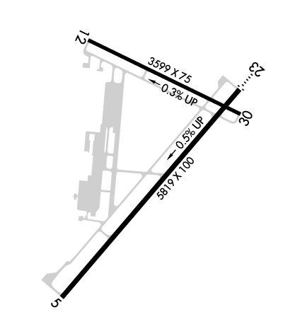
| Lat: N 3925.0 Long: W 07722.5 Elev: 309 Var: +08 Longest Runway: 5819 | ||
| Clr Del: 126.9 Dept. ATIS: 124.87 Arr. ATIS: 124.87 AWOS: 124.87 Ground: 127.42 Tower: 132.4 | ||
| ||||||||||||||||||||||||||||||||||||||||||||
| ||||||||||||||||||||||||||||||||||||||||||||
| ||||||||||||||||||||||||||||||||||||||||||||
| Rwy | Rwy | |||||||
| 5819x100 | 5819' | 5819x100 | 5819' | 110.30 - 228° | ||||
| 3599x75 | 3599' | 3599x75 | 3599' | |||||
| Runway ID | Single Wheel | Double Wheel | Double Tandem Wheel | Dual Double Wheel |
| 05/23 | 60,000 | N/A | N/A | N/A |
| 12/30 | N/A | N/A | N/A | N/A |
| These numbers are Advisory and are not limits. The Airport Manager should have more accurate Weight Limits | ||||
 Airport Diagram might not be current. | |
| Facility Name: | FREDERICK MUNI |
| City Name: | FREDERICK |
| County: | FREDERICK |
| State abbrev: | MD |
| State Name: | MARYLAND |
| Ownership: | PUBLICLY OWNED |
| Use: | OPEN TO THE PUBLIC |
| Owner's Name: | CITY OF FREDERICK |
| Address: | 101 N COURT ST |
| FREDERICK, MD 21701 | |
| Owner's Phone: | 301-600-1380 |
| Manager's Name: | ANDREW MOORE |
| Address: | 111 AIRPORT DRIVE EAST |
| FREDERICK, MD 21701 | |
| Phone: | 301-600-2201; EMERG 301-600-1440 |
| FAA Region: | EASTERN |
| FAA Field Office: | DCA |
| Date | Sunrise | Sunset |
|---|---|---|
| 06/08/26 Monday | 5:42 | 20:35 |
| 06/09/26 Tuesday | 5:42 | 20:35 |
| 06/10/26 Wednesday | 5:42 | 20:36 |
| 06/11/26 Thursday | 5:42 | 20:36 |
| 06/12/26 Friday | 5:42 | 20:37 |
| 06/13/26 Saturday | 5:42 | 20:37 |
| 06/14/26 Sunday | 5:42 | 20:38 |
| 06/15/26 Monday | 5:42 | 20:38 |
| 06/16/26 Tuesday | 5:42 | 20:38 |
| 06/17/26 Wednesday | 5:42 | 20:39 |
| 06/18/26 Thursday | 5:42 | 20:39 |
| 06/19/26 Friday | 5:42 | 20:39 |
| 06/20/26 Saturday | 5:42 | 20:40 |
| 06/21/26 Sunday | 5:43 | 20:40 |
| Airport Attendance Schedule | 7 Days A Week 0700-2100++; FBO UNATNDD ON CHRISTMAS DAY. |
| Airport Status | OPERATIONAL (This Status can change at any time - please check NOTAMS) |
| Airport Lighting Schedule | ACTVT ODALS RWY 23; REIL RWY 12, 23 & 30; PAPI RWY 23; HIRL RWY 05/23; MIRL RWY 12/30 - CTAF. |
| Airport Storage Available | Tie Downs, Hanger |
| Extra Services Available | Avionics, Charter, Flight Instruction, Aircraft Rental, Aircraft Sales |
| Wind Indicator | YES - (lighted) |
| Control Tower | YES |
| CTAF Frequency | 132.400 |
| Unicom Frequency | 122.950 |
| Rotating Beacon Color | WG |
| Segmented Circle | YES |
| Landing Fee | NO |
| Airport Inspected | STATE - performed by STATE AERONAUTICAL PERSONNEL |
| Inspection Date | 05/14/2025 |
| Type of Fuel Available | Grade 100LL, JET A (freeze point -40C); -10SELF SERVE 100LL AVBL H24 WITH CREDIT CARD. |
| Airframe Repair Service | MAJOR |
| Power Plant Repair Service | MAJOR |
| Latitude | N3925.0 |
| Longitude | W07722.5 (ESTIMATED) |
| Arpt Elevation | 308ft (SURVEYED) |
| Magnetic Variation | 08W |
| 0 miles E | of FREDERICK |
| Traffic Pattern Altitude | 600; TPA - 600 AGL HEL, 1100 AGL SNGL AND LGT TWINS, 1600 AGL LRG TWINS AND JETS. |
| Sectional Chart | WASHINGTON |
| Operations (Reported) | Yearly | Avg. Daily |
|---|---|---|
| General Aviation Transient | 0 | 0 |
| General Aviation Local | 0 | 0 |
| Air Taxi | 0 | 0 |
| Commerical | 0 | 0 |
| Commuter | 0 | 0 |
| Military | 0 | 0 |
| Aircraft based on Field | |
|---|---|
| General Aviation Singles | 0 |
| General Aviation Multi | 0 |
| Jet Aircraft | 0 |
| General Aviation Helicopters | 0 |
| Military Aircraft | 0 |
| Gliders | 0 |
| Ultralights | 0 |
| FSS on field | NO |
| FSS tie-in | LEESBURG |
| FSS Phone | 1-800-WX-BRIEF |
| Who issues Notams | FDK |
| Notam D service at airport | YES |
| ARTCC Name | WASHINGTON |
| Airport Certification | |
| Aircraft Rescue & Firefighting Index | None |
| Airport of Entry | No |
| Custom Landing Rights | No |
| Joint Civil/Military | No |
| Military Landing rights | YES |
| NATIONAL PLAN OF INTEGRATED AIRPORT SYSTEMS (NPIAS) |
| GRANT AGREEMENTS UNDER FAAP/ADAP/AIP |
| ASSURANCES PURSUANT TO TITLE VI, CIVIL RIGHTS ACT OF 1964 |
| FOR CD WHEN TWR CLSD CTC POTOMAC APCH 126.9 OR 866-709-4993. |
| RWY 23 -15 FT DEPRESSION 400 FT LONG; 246 FT L OF CNTRLN; PARALLEL TO APCH END. |
Airport Communications & Frequencies:
| |||||||||||||||||||||||||||
| Runway: 05 | Runway: 23 | ||
| Mag heading: | 48° | Mag heading: | 228° |
| Rwy Slope: | -.45% Down | Rwy Slope: | .45% Up |
| Approach: | Approach: | ILS | |
| Pattern: | Right Traffic | Pattern: | Left Traffic |
| Markings: | NONPRECISION INSTRUMENT | Markings: | PRECISION INSTRUMENT |
| Marking Condition: | GOOD | Marking Condition: | FAIR |
| Arresting Dev: | Arresting Dev: | ||
| Lat & Long: | N3924.5 W07722.9 | Lat. & Long.: | N3925.2 W07722.1 |
| Elev: | 308.9 ft. MSL | Elev: | 282.6 ft. MSL |
| TCH: | 43 ft. AGL | TCH: | 54 ft. AGL |
| Visual Glide Path: | 3.00 degrees | Visual Glide Path: | 3.00 degrees |
| Displaced Threshold: | No | Displaced Threshold: | No |
| Touchdown Zone: | YES | Touchdown Zone: | YES |
| Touchdown Elev.: | 308.9 feet | Touchdown Elev.: | 296.6 feet |
| Visual Glide Slope: | 4-Light PAPI on LEFT side of Runway | Visual Glide Slope: | 4-Light PAPI on LEFT side of Runway |
| RVR Equipment: | RVR Equipment: | ||
| RVV Equipment: | NO | RVV Equipment: | NO |
| Approach Lights: | Approach Lights: | ODALS - omnidirectional approach lighting system | |
| REIL: | YES | REIL: | YES |
| Centerline Lights: | NO | Centerline Lights: | NO |
| Touchdown lights: | NO | Touchdown lights: | NO |
| Runway Category: | Runway with a Non-precision Approach having visibility minimums greater than 3/4 mile | Runway Category: | Precision Instrument Runway |
| Declared Distances: | Declared Distances: | ||
| Obstructions: | TREES | Obstructions: | TREES |
| Marked: | NOT Marked/Lighted | Marked: | NOT Marked/Lighted |
| Clearance slope: | 27:1 | Clearance slope: | 24:1 |
| Obstruction height: | 43 feet AGL | Obstruction height: | 111 feet AGL |
| Dist. from runway: | 1383 feet | Dist. from runway: | 2894 feet |
| Centerline offset: | 219 left of centerline | Centerline offset: | 721 feet left of centerline |
| Comments: | Comments: |
| Runway: 12 | Runway: 30 | ||
| Mag heading: | 124° | Mag heading: | 304° |
| Rwy Slope: | -.28% Down | Rwy Slope: | .28% Up |
| Approach: | Approach: | ||
| Pattern: | Right Traffic | Pattern: | Left Traffic |
| Markings: | NONPRECISION INSTRUMENT | Markings: | NONPRECISION INSTRUMENT |
| Marking Condition: | FAIR | Marking Condition: | FAIR |
| Arresting Dev: | Arresting Dev: | ||
| Lat & Long: | N3925.4 W07722.8 | Lat. & Long.: | N3925.1 W07722.1 |
| Elev: | 294.2 ft. MSL | Elev: | 284.0 ft. MSL |
| TCH: | 40 ft. AGL | TCH: | 37 ft. AGL |
| Visual Glide Path: | 3.00 degrees | Visual Glide Path: | 4.00 degrees |
| Displaced Threshold: | No | Displaced Threshold: | No |
| Touchdown Zone: | YES | Touchdown Zone: | YES |
| Touchdown Elev.: | 294.2 feet | Touchdown Elev.: | 290.7 feet |
| Visual Glide Slope: | 2-Light PAPI on LEFT side of Runway | Visual Glide Slope: | 2-Light PAPI on LEFT side of Runway |
| RVR Equipment: | RVR Equipment: | ||
| RVV Equipment: | NO | RVV Equipment: | NO |
| Approach Lights: | Approach Lights: | ||
| REIL: | YES | REIL: | YES |
| Centerline Lights: | NO | Centerline Lights: | NO |
| Touchdown lights: | NO | Touchdown lights: | NO |
| Runway Category: | Runway with a Visual Approach | Runway Category: | Runway with a Visual Approach |
| Declared Distances: | Declared Distances: |
Thanks for using FltPlan.com
all rights reserved © 1999-2026 by Flight Plan LLC
