
| CHESTERFIELD COUNTY RICHMOND VA |
| |
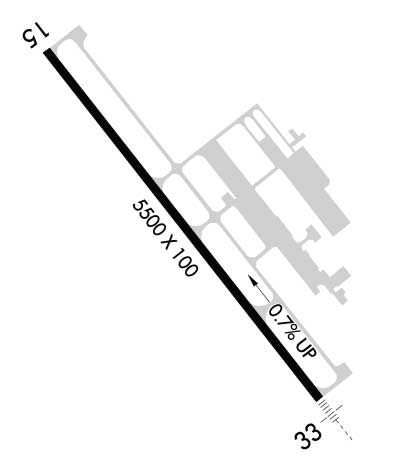
| Lat: N 3724.4 Long: W 07731.5 Elev: 236 Var: +10 Longest Runway: 5500 | ||
| Clr Del: 124.6 AWOS: 128.62 CTAF: 123.05 | ||
| |||||||||||||||||||||||||||||||||||||||||||||||||||||||||||||||||||||
| |||||||||||||||||||||||||||||||||||||||||||||||||||||||||||||||||||||
| |||||||||||||||||||||||||||||||||||||||||||||||||||||||||||||||||||||
| |||||||||||||||||||||||||||||||||||||||||||||||||||||||||||||||||||||
| Rwy | Rwy | |||||||
| 5500x100 | 5500' | 5500x100 | 5500' | 108.30 - 331° | ||||
| Runway ID | Single Wheel | Double Wheel | Double Tandem Wheel | Dual Double Wheel |
| 15/33 | 60,000 | 80,000 | N/A | N/A |
| These numbers are Advisory and are not limits. The Airport Manager should have more accurate Weight Limits | ||||
 Airport Diagram might not be current. | |
| Facility Name: | RICHMOND EXEC-CHESTERFIELD COUNTY |
| City Name: | RICHMOND |
| County: | CHESTERFIELD |
| State abbrev: | VA |
| State Name: | VIRGINIA |
| Ownership: | PUBLICLY OWNED |
| Use: | OPEN TO THE PUBLIC |
| Owner's Name: | CHESTERFIELD CO; BOARD OF SUPERVISORS. |
| Address: | PO BOX 40 |
| CHESTERFIELD, VA 23832-0040 | |
| Owner's Phone: | 804-748-1215 |
| Manager's Name: | JEREMY WILKINSON |
| Address: | 7511 AIRFIELD DRIVE |
| RICHMOND, VA 23237-2252 | |
| Phone: | 804-768-7722 |
| FAA Region: | EASTERN |
| FAA Field Office: | DCA |
| Date | Sunrise | Sunset |
|---|---|---|
| 09/24/21 Friday | 6:59 | 19:04 |
| 09/25/21 Saturday | 7:00 | 19:03 |
| 09/26/21 Sunday | 7:01 | 19:01 |
| 09/27/21 Monday | 7:02 | 19:00 |
| 09/28/21 Tuesday | 7:03 | 18:58 |
| 09/29/21 Wednesday | 7:04 | 18:57 |
| 09/30/21 Thursday | 7:04 | 18:55 |
| 10/01/21 Friday | 7:05 | 18:54 |
| 10/02/21 Saturday | 7:06 | 18:52 |
| 10/03/21 Sunday | 7:07 | 18:51 |
| 10/04/21 Monday | 7:08 | 18:49 |
| 10/05/21 Tuesday | 7:09 | 18:48 |
| 10/06/21 Wednesday | 7:10 | 18:46 |
| 10/07/21 Thursday | 7:11 | 18:45 |
| Airport Attendance Schedule | 7 Days A Week 0700-2200 |
| Airport Status | OPERATIONAL (This Status can change at any time - please check NOTAMS) |
| Airport Lighting Schedule | HIRL RY 15/33 PRESET LOW INTST; INCR INTST & ACTVT MALSR RY 33 & REIL RY 15 - CTAF. |
| Airport Storage Available | Tie Downs, Hanger |
| Extra Services Available | Air Freight, Charter, Flight Instruction, Aircraft Rental, Aircraft Sales, Annual Surveying |
| Wind Indicator | YES - (lighted) |
| Control Tower | NO |
| CTAF Frequency | 123.050 |
| Unicom Frequency | 123.050 |
| Rotating Beacon Color | CLEAR-GREEN (Light Land Airport) |
| Segmented Circle | YES |
| Landing Fee | NO |
| Airport Inspected | STATE - performed by STATE AERONAUTICAL PERSONNEL |
| Inspection Date | 04/13/2021 |
| Type of Fuel Available | Grade 100LL, JET A (freeze point -40C); -10FUEL AFT HRS CALL 804-271-7793 BTN 2200-0700. |
| Airframe Repair Service | MAJOR |
| Power Plant Repair Service | MAJOR |
| Latitude | N3724.4 |
| Longitude | W07731.5 (ESTIMATED) |
| Arpt Elevation | 236ft (SURVEYED) |
| Magnetic Variation | 10W |
| 4 miles SW | of RICHMOND |
| Traffic Pattern Altitude | TPA SINGLE ENGINE ACFT (1000 FT AGL) MULTI ENGINE ACFT (1500 FT AGL). |
| Sectional Chart | WASHINGTON |
| Operations (Reported) | Yearly | Avg. Daily |
|---|---|---|
| General Aviation Transient | 10323 | 28 |
| General Aviation Local | 55374 | 152 |
| Air Taxi | 956 | 3 |
| Commerical | 0 | 0 |
| Commuter | 0 | 0 |
| Military | 970 | 3 |
| Aircraft based on Field | |
|---|---|
| General Aviation Singles | 66 |
| General Aviation Multi | 16 |
| Jet Aircraft | 8 |
| General Aviation Helicopters | 5 |
| Military Aircraft | 0 |
| Gliders | 0 |
| Ultralights | 0 |
| FSS on field | NO |
| FSS tie-in | LEESBURG |
| FSS Phone | 1-800-WX-BRIEF |
| Who issues Notams | DCA |
| Notam D service at airport | YES |
| ARTCC Name | WASHINGTON |
| Airport Certification | ARFF INDEX A. |
| Aircraft Rescue & Firefighting Index | ARFF EQUIPMENT AND TRAINED PERSONNEL AVAILABLE AT AIRPORT. |
| Airport of Entry | No |
| Custom Landing Rights | YES |
| Joint Civil/Military | No |
| Military Landing rights | YES |
| NATIONAL PLAN OF INTEGRATED AIRPORT SYSTEMS (NPIAS) |
| GRANT AGREEMENTS UNDER FAAP/ADAP/AIP |
| ASSURANCES PURSUANT TO TITLE VI, CIVIL RIGHTS ACT OF 1964 |
| ACFT ON ILS APCH TO RICHMOND INTL CROSSING OVER ARPT. |
| 400 FT TWR 5 NM N ARPT. |
| NOISE SENSITIVE AREA NORTH OF ARPT.NO WIND VOLUNTARY USE OF RY 15 PREFERRED. |
| DEER & BIRDS ON & INVOF ARPT. |
| HELICOPTER PARKING ADJACENT TO TW 'C' |
| MED-FLIGHT: IRREGULAR DEPARTURE PATTERN |
| ARFF EQUIPMENT AND TRAINED PERSONNEL AVAILABLE AT AIRPORT. |
| FOR CD CTC POTOMAC APCH AT 866-640-4124. |
Airport Communications & Frequencies:
| |||||||||||||||||||||||||||
| Runway: 15 | Runway: 33 | ||
| Mag heading: | 151° | Mag heading: | 331° |
| Rwy Slope: | -.68% Down | Rwy Slope: | .68% Up |
| Approach: | Approach: | ILS/DME | |
| Pattern: | Left Traffic | Pattern: | Left Traffic |
| Markings: | NONPRECISION INSTRUMENT | Markings: | PRECISION INSTRUMENT |
| Marking Condition: | GOOD | Marking Condition: | GOOD |
| Arresting Dev: | Arresting Dev: | ||
| Lat & Long: | N3724.7 W07731.8 | Lat. & Long.: | N3724.0 W07731.1 |
| Elev: | 236.1 ft. MSL | Elev: | 198.8 ft. MSL |
| TCH: | 43 ft. AGL | TCH: | 50 ft. AGL |
| Visual Glide Path: | 3.00 degrees | Visual Glide Path: | 3.00 degrees |
| Displaced Threshold: | No | Displaced Threshold: | No |
| Touchdown Zone: | YES | Touchdown Zone: | YES |
| Touchdown Elev.: | 236.1 feet | Touchdown Elev.: | 217.2 feet |
| Visual Glide Slope: | 4-Light PAPI on LEFT side of Runway | Visual Glide Slope: | 4-Light PAPI on LEFT side of Runway |
| RVR Equipment: | RVR Equipment: | ||
| RVV Equipment: | NO | RVV Equipment: | NO |
| Approach Lights: | Approach Lights: | MALSR - 1,400 foot medium intensity approach lighting system with runway alignment indicator lights | |
| REIL: | YES | REIL: | NO |
| Centerline Lights: | NO | Centerline Lights: | NO |
| Touchdown lights: | NO | Touchdown lights: | NO |
| Runway Category: | Runway with a Non-precision Approach having visibility minimums greater than 3/4 mile | Runway Category: | Precision Instrument Runway |
| Declared Distances: | Declared Distances: | ||
| Obstructions: | TREES | Obstructions: | BRUSH |
| Marked: | NOT Marked/Lighted | Marked: | NOT Marked/Lighted |
| Clearance slope: | 24:1 | Clearance slope: | 23:1 |
| Obstruction height: | 64 feet AGL | Obstruction height: | 23 feet AGL |
| Dist. from runway: | 1788 feet | Dist. from runway: | 745 feet |
| Centerline offset: | 480 right of centerline | Centerline offset: | 414 feet right of centerline |
| Comments: | Comments: |
Thanks for using FltPlan.com
all rights reserved © 1999-2021 by Flight Plan LLC


