
| FARIBAULT MUNI FARIBAULT MN |
| |
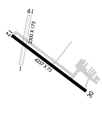
| Lat: N 4419.7 Long: W 09318.8 Elev: 1060 Var: -02 Longest Runway: 4257 | ||
| AWOS: 111.2 CTAF: 122.8 | ||
| ||||||||||||||||||||||||||||||||||||||||||||
| ||||||||||||||||||||||||||||||||||||||||||||
| ||||||||||||||||||||||||||||||||||||||||||||
| Rwy | Rwy | |||||||
| 2300x175 | 2300' | 2300x175 | 2300' | |||||
| 4257x75 | 4257' | 4257x75 | 4027' | |||||
| Runway ID | Single Wheel | Double Wheel | Double Tandem Wheel | Dual Double Wheel |
| 01/19 | N/A | N/A | N/A | N/A |
| 12/30 | 16,000 | 22,000 | N/A | N/A |
| These numbers are Advisory and are not limits. The Airport Manager should have more accurate Weight Limits | ||||
 Airport Diagram might not be current. | |
| Facility Name: | FARIBAULT MUNI-LIZ WALL STROHFUS FLD |
| City Name: | FARIBAULT |
| County: | RICE |
| State abbrev: | MN |
| State Name: | MINNESOTA |
| Ownership: | PUBLICLY OWNED |
| Use: | OPEN TO THE PUBLIC |
| Owner's Name: | CITY OF FARIBAULT |
| Address: | 208 1ST AVE, NW |
| FARIBAULT, MN 55021 | |
| Owner's Phone: | 507-334-2222 |
| Manager's Name: | QUALITY AVIATION INC. |
| Address: | 3401 HWY 21 WEST, STE 1 |
| FARIBAULT, MN 55021 | |
| Phone: | 507-332-0140 |
| FAA Region: | GREAT LAKES |
| FAA Field Office: | DMA |
| Date | Sunrise | Sunset |
|---|---|---|
| 06/08/26 Monday | 5:29 | 20:55 |
| 06/09/26 Tuesday | 5:29 | 20:56 |
| 06/10/26 Wednesday | 5:29 | 20:57 |
| 06/11/26 Thursday | 5:29 | 20:57 |
| 06/12/26 Friday | 5:29 | 20:58 |
| 06/13/26 Saturday | 5:29 | 20:58 |
| 06/14/26 Sunday | 5:28 | 20:59 |
| 06/15/26 Monday | 5:28 | 20:59 |
| 06/16/26 Tuesday | 5:28 | 20:59 |
| 06/17/26 Wednesday | 5:29 | 21:00 |
| 06/18/26 Thursday | 5:29 | 21:00 |
| 06/19/26 Friday | 5:29 | 21:00 |
| 06/20/26 Saturday | 5:29 | 21:01 |
| 06/21/26 Sunday | 5:29 | 21:01 |
| Airport Attendance Schedule | MAY-SEP 7 Days A Week 0800-1800, OCT-APR SAT 1000-1500, OCT-APR SUN UNATNDD, OCT-APR MON-FRI 0800-1800; FOR SVS AFT HRS CALL 507-838-7152 |
| Airport Status | OPERATIONAL (This Status can change at any time - please check NOTAMS) |
| Airport Lighting Schedule | MIRL RY 12/30 PRESET TO LOW; TO INCR INTST AND ACTVT REIL RY 12 & RY 30 - CTAF. |
| Airport Storage Available | Tie Downs, Hanger |
| Extra Services Available | Glider, Flight Instruction, Aircraft Rental, Aircraft Sales |
| Wind Indicator | YES - (lighted) |
| Control Tower | NO |
| CTAF Frequency | 122.800 |
| Unicom Frequency | 122.800 |
| Rotating Beacon Color | WG |
| Segmented Circle | NO |
| Landing Fee | NO |
| Airport Inspected | STATE - performed by STATE AERONAUTICAL PERSONNEL |
| Inspection Date | 05/25/2023 |
| Type of Fuel Available | Grade 100LL, JET A (freeze point -40C); -10SELF SVC FUEL WITH CREDIT CARD. |
| Airframe Repair Service | MAJOR |
| Power Plant Repair Service | MAJOR |
| Latitude | N4419.7 |
| Longitude | W09318.8 (ESTIMATED) |
| Arpt Elevation | 1060ft (SURVEYED) |
| Magnetic Variation | 02E |
| 3 miles NW | of FARIBAULT |
| Traffic Pattern Altitude | |
| Sectional Chart | OMAHA |
| Operations (Reported) | Yearly | Avg. Daily |
|---|---|---|
| General Aviation Transient | 0 | 0 |
| General Aviation Local | 0 | 0 |
| Air Taxi | 0 | 0 |
| Commerical | 0 | 0 |
| Commuter | 0 | 0 |
| Military | 0 | 0 |
| Aircraft based on Field | |
|---|---|
| General Aviation Singles | 0 |
| General Aviation Multi | 0 |
| Jet Aircraft | 0 |
| General Aviation Helicopters | 0 |
| Military Aircraft | 0 |
| Gliders | 0 |
| Ultralights | 0 |
| FSS on field | NO |
| FSS tie-in | PRINCETON |
| FSS Phone | 1-800-WX-BRIEF |
| Who issues Notams | FBL |
| Notam D service at airport | YES |
| ARTCC Name | MINNEAPOLIS |
| Airport Certification | |
| Aircraft Rescue & Firefighting Index | None |
| Airport of Entry | No |
| Custom Landing Rights | No |
| Joint Civil/Military | No |
| Military Landing rights | YES |
| NATIONAL PLAN OF INTEGRATED AIRPORT SYSTEMS (NPIAS) |
| GRANT AGREEMENTS UNDER FAAP/ADAP/AIP |
| ASSURANCES PURSUANT TO TITLE VI, CIVIL RIGHTS ACT OF 1964 |
| GCO AVBL ON FREQ 121.725 THRU MSP CD & FLT SVCS. |
| ULTRALIGHTS & GLDRS USE TAXIWAY AND EXTENDED TAXIWAY PARALLEL TO RY 12/30. ULTRALIGHTS & GLDRS USING TAXIWAY FLY PATTERN ON 'NE' SIDE OF RY 12/30. |
| WHEN LNDG ON RY 12, BE ALERT FOR TURBULENCE & POSS WINDSHEAR WHEN WINDS ARE OUT OF THE SOUTH. |
| FOR CD CTC MINNEAPOLIS APCH AT 612-713-4016. |
| RWY 01-19 NOT PLOWED WINTER MONTHS. OPEN FOR SKIPLANES. |
Airport Communications & Frequencies:
| ||||||||||||||
| Runway: 01 | Runway: 19 | ||
| Mag heading: | 8° | Mag heading: | 188° |
| Rwy Slope: | .14% Up | Rwy Slope: | -.14% Down |
| Approach: | Approach: | ||
| Pattern: | Left Traffic | Pattern: | Left Traffic |
| Markings: | NONSTANDARD | Markings: | NONSTANDARD |
| Marking Condition: | FAIR; RY 01/19 MARKED WITH YELLOW CONES. | Marking Condition: | FAIR |
| Arresting Dev: | Arresting Dev: | ||
| Lat & Long: | N4419.7 W09319.0 | Lat. & Long.: | N4420.0 W09318.9 |
| Elev: | 1051.3 ft. MSL | Elev: | 1054.6 ft. MSL |
| TCH: | TCH: | ||
| Visual Glide Path: | Visual Glide Path: | ||
| Displaced Threshold: | No | Displaced Threshold: | No |
| Touchdown Zone: | YES | Touchdown Zone: | YES |
| Touchdown Elev.: | 1056.7 feet | Touchdown Elev.: | 1056.7 feet |
| Visual Glide Slope: | Visual Glide Slope: | ||
| RVR Equipment: | RVR Equipment: | ||
| RVV Equipment: | NO | RVV Equipment: | NO |
| Approach Lights: | Approach Lights: | ||
| REIL: | NO | REIL: | NO |
| Centerline Lights: | NO | Centerline Lights: | NO |
| Touchdown lights: | NO | Touchdown lights: | NO |
| Runway Category: | Runway with a Visual Approach | Runway Category: | Runway with a Visual Approach |
| Declared Distances: | Declared Distances: | ||
| Obstructions: | TREES | Obstructions: | |
| Marked: | NOT Marked/Lighted | Marked: | |
| Clearance slope: | 16:1 | Clearance slope: | 20:1 |
| Obstruction height: | 78 feet AGL | Obstruction height: | |
| Dist. from runway: | 1295 feet | Dist. from runway: | |
| Centerline offset: | 221 left of centerline | Centerline offset: | |
| Comments: | Comments: |
| Runway: 12 | Runway: 30 | ||
| Mag heading: | 125° | Mag heading: | 305° |
| Rwy Slope: | -.27% Down | Rwy Slope: | .27% Up |
| Approach: | Approach: | ||
| Pattern: | Left Traffic | Pattern: | Left Traffic |
| Markings: | NONPRECISION INSTRUMENT | Markings: | NONPRECISION INSTRUMENT |
| Marking Condition: | FAIR | Marking Condition: | FAIR |
| Arresting Dev: | Arresting Dev: | ||
| Lat & Long: | N4419.9 W09319.1 | Lat. & Long.: | N4419.5 W09318.3 |
| Elev: | 1060.0 ft. MSL | Elev: | 1048.4 ft. MSL |
| TCH: | 40 ft. AGL | TCH: | 40 ft. AGL |
| Visual Glide Path: | 3.00 degrees | Visual Glide Path: | 3.00 degrees |
| Displaced Threshold: | No | Displaced Threshold: | 230 feet |
| Touchdown Zone: | YES | Touchdown Zone: | YES |
| Touchdown Elev.: | 1060.1 feet | Touchdown Elev.: | 1055.5 feet |
| Visual Glide Slope: | 4-Light PAPI on LEFT side of Runway; RY 12 PAPI OPERATE CONTINUOUSLY. | Visual Glide Slope: | 4-Light PAPI on LEFT side of Runway; RY 30 PAPI OPERATE CONTINUOUSLY. |
| RVR Equipment: | RVR Equipment: | ||
| RVV Equipment: | NO | RVV Equipment: | NO |
| Approach Lights: | Approach Lights: | ||
| REIL: | YES | REIL: | YES |
| Centerline Lights: | NO | Centerline Lights: | NO |
| Touchdown lights: | NO | Touchdown lights: | NO |
| Runway Category: | Runway with a Non-precision Approach having visibility minimums greater than 3/4 mile | Runway Category: | Runway with a Non-precision Approach having visibility minimums greater than 3/4 mile |
| Declared Distances: | Declared Distances: | ||
| Obstructions: | TREE | Obstructions: | ROAD |
| Marked: | NOT Marked/Lighted | Marked: | NOT Marked/Lighted |
| Clearance slope: | 1:1 | Clearance slope: | 27:1; RY 30 ROAD +14, 580 FM END, 280R, APCH SLOPE 57:1 FM DSPLCD THLD. |
| Obstruction height: | 37 feet AGL | Obstruction height: | 14 feet AGL |
| Dist. from runway: | 263 feet | Dist. from runway: | 580 feet |
| Centerline offset: | 246 right of centerline | Centerline offset: | 280 feet right of centerline |
| Comments: | RWY 12 HAS 20 FT TREE 120 FT FM THE RWY END AND 153 FT R. | Comments: |
Thanks for using FltPlan.com
all rights reserved © 1999-2026 by Flight Plan LLC
