
| FELKER AAF (PRIVATE) FORT EUSTIS VA |
| |
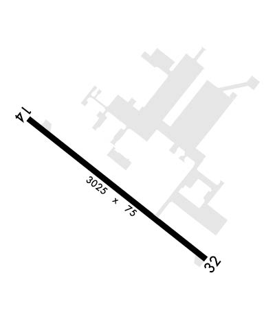
| Lat: N 3708.0 Long: W 07636.5 Elev: 12 Var: +11 Longest Runway: 3025 | ||
| Ground: 121.35 Tower: 126.3 | ||
| ||||||||||||||||||||||||||||||||
| ||||||||||||||||||||||||||||||||
| Rwy | Rwy | |||||||
| 3025x75 | 3025' | 3025x75 | 3025' | |||||
| Runway ID | Single Wheel | Double Wheel | Double Tandem Wheel | Dual Double Wheel |
| 14/32 | N/A | N/A | N/A | N/A |
| These numbers are Advisory and are not limits. The Airport Manager should have more accurate Weight Limits | ||||
 Airport Diagram might not be current. | |
| Facility Name: | FELKER AAF |
| City Name: | FORT EUSTIS |
| County: | NEWPORT NEWS |
| State abbrev: | VA |
| State Name: | VIRGINIA |
| Ownership: | ARMY OWNED |
| Use: | PRIVATE |
| Owner's Name: | US ARMY ATCA-ASO |
| Address: | CAMERON STA |
| ALEXANDRIA, VA 22314 | |
| Owner's Phone: | |
| Manager's Name: | USAR OPS |
| Address: | |
| Phone: | 757-878-2865; X225. |
| FAA Region: | EASTERN |
| FAA Field Office: | DCA |
| Date | Sunrise | Sunset |
|---|---|---|
| 09/24/21 Friday | 6:56 | 19:01 |
| 09/25/21 Saturday | 6:57 | 18:59 |
| 09/26/21 Sunday | 6:57 | 18:58 |
| 09/27/21 Monday | 6:58 | 18:56 |
| 09/28/21 Tuesday | 6:59 | 18:55 |
| 09/29/21 Wednesday | 7:00 | 18:53 |
| 09/30/21 Thursday | 7:01 | 18:52 |
| 10/01/21 Friday | 7:02 | 18:50 |
| 10/02/21 Saturday | 7:02 | 18:49 |
| 10/03/21 Sunday | 7:03 | 18:47 |
| 10/04/21 Monday | 7:04 | 18:46 |
| 10/05/21 Tuesday | 7:05 | 18:44 |
| 10/06/21 Wednesday | 7:06 | 18:43 |
| 10/07/21 Thursday | 7:07 | 18:41 |
| Airport Attendance Schedule | MON-FRI 1145-0400Z++, EXP FEDERAL HOL |
| Airport Status | OPERATIONAL (This Status can change at any time - please check NOTAMS) |
| Airport Lighting Schedule | ACTVT PAPI RWY 14, 32; MIRL RWY 14/32, ODALS RWY 14-CTAF. |
| Airport Storage Available | NONE |
| Extra Services Available | NONE |
| Wind Indicator | NONE |
| Control Tower | YES |
| CTAF Frequency | 126.300 |
| Unicom Frequency | |
| Rotating Beacon Color | SPLIT-CLEAR-GREEN (LIGHTED MILITARY AIRPORT) |
| Segmented Circle | NO |
| Landing Fee |
| Airport Inspected | No Inspection Data Available performed by the OWNER |
| Inspection Date | Unknown |
| Type of Fuel Available | None |
| Airframe Repair Service | None |
| Power Plant Repair Service | None |
| Latitude | N3708.0 |
| Longitude | W07636.5 (ESTIMATED) |
| Arpt Elevation | 11ft (ESTIMATED) |
| Magnetic Variation | 11W |
| 0 miles | of FORT EUSTIS |
| Traffic Pattern Altitude | |
| Sectional Chart | WASHINGTON |
| Operations (Reported) | Yearly | Avg. Daily |
|---|---|---|
| General Aviation Transient | 0 | 0 |
| General Aviation Local | 0 | 0 |
| Air Taxi | 0 | 0 |
| Commerical | 0 | 0 |
| Commuter | 0 | 0 |
| Military | 0 | 0 |
| Aircraft based on Field | |
|---|---|
| General Aviation Singles | 0 |
| General Aviation Multi | 0 |
| Jet Aircraft | 0 |
| General Aviation Helicopters | 0 |
| Military Aircraft | 0 |
| Gliders | 0 |
| Ultralights | 0 |
| FSS on field | NO |
| FSS tie-in | LEESBURG |
| FSS Phone | 1-800-WX-BRIEF |
| Who issues Notams | DCA |
| Notam D service at airport | YES |
| ARTCC Name | WASHINGTON |
| Airport Certification | |
| Aircraft Rescue & Firefighting Index | None |
| Airport of Entry | No |
| Custom Landing Rights | No |
| Joint Civil/Military | No |
| Military Landing rights | No |
| JASU: 2(AGPU). |
| REMOTE BRIEFING AVBL FR SHAW AFB DSN 965-0939/40/41, (FAX) DSN 965-0527. USE C877-297-4129 IF DSN NOT AVBL. |
| MISC: FRANGIBLE PERIMETER FENCE ENCLOSING RWY ENVIRONMENT EXISTS WITHIN 500 FT OF RWY CNTRLN. MULTIPLE BLDGS. PENETRATING 7:1 IMAGINARY SURFACE, NE SIDE OF RY. PARKING LOTS/LGT POLES/AND MULTIPLE FRANGIBLE OBJECTS W/IN 500 FT NE OR RY CNTLNE. EMERG DISPATCH MONITORS CTAF, 2300-0700Z++. |
| EMERGENCY SERVICES MONITORS CTAF AFTER HOURS. |
| AFTER HOUR OPS RESTRICTED TO DOD, STATE/FED MSN ESSENTIAL OPS ONLY. |
| FOR CD WHEN ATCT CLSD, CTC NORFOLK APCH AT C757-363-5864. |
| REMARKS: CLASS D AIRSPACE EFF 1200-0400Z++ MON-FRI EXEC HOL. OT CLASS G. EMERG DISPATCH MNT CTAF AFT HR. |
| TRAN ALERT: SVC AVBL 1100-2100Z++ MON - FRI EXC FEDERAL HOL. |
| REMARKS: BASE OPS 1145-0400Z++ MON-FRI EXC HOL, DSN 826-5828/2584, C757-878-5828/2584. |
| RSTD: PPR 24 HR NOTICE ALL NON KFAF BASED ACFT, CTC BASE OPS. ACFT ENTERING FR SSE MAX ALT 500 FT DUE TO INST APCH INTO NEWPORT NEWS/WSMBG ARPT. NO HAZARD CARGO AREA AVBL. |
| CAUTION: CTC BASOPS FOR CURRENT BASH COND. INCRD BIRD ACTVTY 1 OCT TO 30 NOV AND 1 FEB TO 31 MAR. SGFNT EAGLE ACTVTY IN VCNTY OF 1 NM S APCH END RWY 32, 1 NM E OF ARPT ON WARWICK RIVER.NO ACFT OTFC OF MAIN POST. PERM MOVBL CRANE ON WATERCRAFT BASE 3100 FT WNW OF RWY 14 APCH END. NO FLY AREA 1.6 NM SE RWY 32 TO INCL ENTR PEN. |
| TFC PAT; F/W 1000 FT, RGT TFC RY 14. R/W 500 FT. |
| MISC: WX FCST ON DUTY 1030-0400Z++ MON-FRI EXC HOL, C757-878-5300, DSN 826-5300. REMOTE BRIEFING AVBL FR SHAW AFB DSN 965-0588, (FAX) DSN 965-1527. USE C877-297-4129 IF DSN NOT AVBL. FLIGHT SERVICES 1-800-WX-BRIEF. WX OBSN VIS RSTD TO 1/2 SM FR NW TO NE; 1/4 TO 3/4 SM ALL OTHER QUAD. WHEN TWR AND/OR SFC VIS IS BLW 4 SM AND DIFFER BY A REPORTABLE VALUE, A TWR VIS |
Airport Communications & Frequencies:
| |||||||||||||||||||||||||||
| Runway: 14 | Runway: 32 | ||
| Mag heading: | N/A | Mag heading: | N/A |
| Rwy Slope: | -.03% Down | Rwy Slope: | .03% Up |
| Approach: | Approach: | ||
| Pattern: | Right Traffic | Pattern: | Left Traffic |
| Markings: | NONPRECISION INSTRUMENT | Markings: | NONPRECISION INSTRUMENT |
| Marking Condition: | GOOD | Marking Condition: | GOOD |
| Arresting Dev: | Arresting Dev: | ||
| Lat & Long: | N3708.1 W07636.8 | Lat. & Long.: | N3707.8 W07636.3 |
| Elev: | 10.0 ft. MSL | Elev: | 9.0 ft. MSL |
| TCH: | 48 ft. AGL | TCH: | 48 ft. AGL |
| Visual Glide Path: | 3.00 degrees | Visual Glide Path: | 3.00 degrees |
| Displaced Threshold: | No | Displaced Threshold: | No |
| Touchdown Zone: | YES | Touchdown Zone: | YES |
| Touchdown Elev.: | 11.6 feet | Touchdown Elev.: | 11.6 feet |
| Visual Glide Slope: | 2-Light PAPI on LEFT side of Runway | Visual Glide Slope: | 2-Light PAPI on LEFT side of Runway; UNUSBL BYD 9 DEGREES RIGHT AND 7 DEGREES LEFT OF CTRLN. |
| RVR Equipment: | RVR Equipment: | ||
| RVV Equipment: | NO | RVV Equipment: | NO |
| Approach Lights: | ODALS - omnidirectional approach lighting system; ODALS RY 14 CONTROLLED BY ATCT. | Approach Lights: | |
| REIL: | NO | REIL: | NO |
| Centerline Lights: | NO | Centerline Lights: | NO |
| Touchdown lights: | NO | Touchdown lights: | NO |
| Runway Category: | Runway Category: | ||
| Declared Distances: | Declared Distances: |
Thanks for using FltPlan.com
all rights reserved © 1999-2021 by Flight Plan LLC
