
| HAYFORK HAYFORK CA |
| |
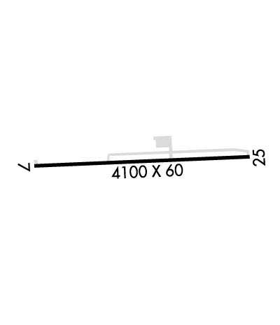
| Lat: N 4032.8 Long: W 12310.8 Elev: 2334 Var: -17 Longest Runway: 4100 | ||
| CTAF: 122.8 | ||
| ||||||||||||||||||||||||||||||||
| ||||||||||||||||||||||||||||||||
| Rwy | Rwy | |||||||
| 4100x60 | 4100' | 4100x60 | 4100' | |||||
| Runway ID | Single Wheel | Double Wheel | Double Tandem Wheel | Dual Double Wheel |
| 07/25 | 12,500 | N/A | N/A | N/A |
| These numbers are Advisory and are not limits. The Airport Manager should have more accurate Weight Limits | ||||
| FltPlan does not have IFR approach charts available for KF62. |
 Airport Diagram might not be current. | |
| Facility Name: | HAYFORK |
| City Name: | HAYFORK |
| County: | TRINITY |
| State abbrev: | CA |
| State Name: | CALIFORNIA |
| Ownership: | PUBLICLY OWNED |
| Use: | OPEN TO THE PUBLIC |
| Owner's Name: | COUNTY OF TRINITY |
| Address: | PO BOX 2490 |
| WEAVERVILLE, CA 96093-0476 | |
| Owner's Phone: | 530-623-1365 |
| Manager's Name: | PANOS KOKKAS; DIRECTOR OF TRANSPORTATION; OFFICE IN WEAVERVILLE. |
| Address: | PO BOX 2490 |
| WEAVERVILLE, CA 96093-0476 | |
| Phone: | 530-623-1365 |
| FAA Region: | WESTERN-PACIFIC |
| FAA Field Office: | SFO |
| Date | Sunrise | Sunset |
|---|---|---|
| 06/07/26 Sunday | 5:42 | 20:41 |
| 06/08/26 Monday | 5:42 | 20:42 |
| 06/09/26 Tuesday | 5:42 | 20:42 |
| 06/10/26 Wednesday | 5:42 | 20:43 |
| 06/11/26 Thursday | 5:42 | 20:43 |
| 06/12/26 Friday | 5:41 | 20:44 |
| 06/13/26 Saturday | 5:41 | 20:44 |
| 06/14/26 Sunday | 5:41 | 20:45 |
| 06/15/26 Monday | 5:41 | 20:45 |
| 06/16/26 Tuesday | 5:41 | 20:45 |
| 06/17/26 Wednesday | 5:42 | 20:46 |
| 06/18/26 Thursday | 5:42 | 20:46 |
| 06/19/26 Friday | 5:42 | 20:46 |
| 06/20/26 Saturday | 5:42 | 20:47 |
| Airport Attendance Schedule | UNATTENDED |
| Airport Status | OPERATIONAL (This Status can change at any time - please check NOTAMS) |
| Airport Lighting Schedule | ACTVT MIRL RWY 07/25 - CTAF. MIRL RWY 07/25 OTS INDEF; DUSK TO DAWN. OTS INDEF |
| Airport Storage Available | Tie Downs |
| Extra Services Available | Flight Instruction |
| Wind Indicator | YES - (lighted) |
| Control Tower | NO |
| CTAF Frequency | 122.800 |
| Unicom Frequency | 122.800 |
| Rotating Beacon Color | WG |
| Segmented Circle | YES |
| Landing Fee | NO |
| Airport Inspected | STATE - performed by STATE AERONAUTICAL PERSONNEL |
| Inspection Date | 09/25/2025 |
| Type of Fuel Available | None |
| Airframe Repair Service | MINOR |
| Power Plant Repair Service | MINOR |
| Latitude | N4032.8 |
| Longitude | W12310.8 (ESTIMATED) |
| Arpt Elevation | 2333ft (SURVEYED) |
| Magnetic Variation | 17E |
| 1 miles S | of HAYFORK |
| Traffic Pattern Altitude | |
| Sectional Chart | KLAMATH FALLS |
| Operations (Reported) | Yearly | Avg. Daily |
|---|---|---|
| General Aviation Transient | 0 | 0 |
| General Aviation Local | 0 | 0 |
| Air Taxi | 0 | 0 |
| Commerical | 0 | 0 |
| Commuter | 0 | 0 |
| Military | 0 | 0 |
| Aircraft based on Field | |
|---|---|
| General Aviation Singles | 0 |
| General Aviation Multi | 0 |
| Jet Aircraft | 0 |
| General Aviation Helicopters | 0 |
| Military Aircraft | 0 |
| Gliders | 0 |
| Ultralights | 0 |
| FSS on field | NO |
| FSS tie-in | RANCHO MURIETA |
| FSS Phone | 1-800-WX-BRIEF |
| Who issues Notams | RIU |
| Notam D service at airport | YES |
| ARTCC Name | OAKLAND |
| Airport Certification | |
| Aircraft Rescue & Firefighting Index | None |
| Airport of Entry | No |
| Custom Landing Rights | No |
| Joint Civil/Military | No |
| Military Landing rights | YES |
| NATIONAL PLAN OF INTEGRATED AIRPORT SYSTEMS (NPIAS) |
| GRANT AGREEMENTS UNDER FAAP/ADAP/AIP |
| ASSURANCES PURSUANT TO TITLE VI, CIVIL RIGHTS ACT OF 1964 |
| HIGH TERRAIN ALL QUADRANTS. |
| NOISE ABATEMENT PROCEDURES IN EFFECT N, NE & S OF ARPT. |
| INTERMITTENTLY CLOSED WINTERS DUE TO SNOW. CTC COUNTY TRANSPORTATION OFFICE FOR INFO 530-623-1365. |
| FOR CD CTC OAKLAND ARTCC AT 510-745-3380. |
| Runway: 07 | Runway: 25 | ||
| Mag heading: | 70° | Mag heading: | 250° |
| Rwy Slope: | .44% Up | Rwy Slope: | -.44% Down |
| Approach: | Approach: | ||
| Pattern: | Left Traffic | Pattern: | Right Traffic |
| Markings: | BASIC | Markings: | BASIC |
| Marking Condition: | FAIR | Marking Condition: | FAIR |
| Arresting Dev: | Arresting Dev: | ||
| Lat & Long: | N4032.8 W12311.2 | Lat. & Long.: | N4032.8 W12310.3 |
| Elev: | 2315.6 ft. MSL | Elev: | 2333.8 ft. MSL |
| TCH: | TCH: | ||
| Visual Glide Path: | Visual Glide Path: | ||
| Displaced Threshold: | No | Displaced Threshold: | No |
| Touchdown Zone: | YES | Touchdown Zone: | YES |
| Touchdown Elev.: | 2328.6 feet | Touchdown Elev.: | 2333.8 feet |
| Visual Glide Slope: | Visual Glide Slope: | ||
| RVR Equipment: | RVR Equipment: | ||
| RVV Equipment: | NO | RVV Equipment: | NO |
| Approach Lights: | Approach Lights: | ||
| REIL: | NO | REIL: | NO |
| Centerline Lights: | NO | Centerline Lights: | NO |
| Touchdown lights: | NO | Touchdown lights: | NO |
| Runway Category: | Runway with a Visual Approach | Runway Category: | Runway with a Visual Approach |
| Declared Distances: | Declared Distances: | ||
| Obstructions: | TREE | Obstructions: | TREE |
| Marked: | NOT Marked/Lighted | Marked: | NOT Marked/Lighted |
| Clearance slope: | 10:1 | Clearance slope: | 15:1 |
| Obstruction height: | 13 feet AGL | Obstruction height: | 43 feet AGL |
| Dist. from runway: | 330 feet | Dist. from runway: | 850 feet |
| Centerline offset: | 65 right of centerline | Centerline offset: | |
| Comments: | Comments: |
Thanks for using FltPlan.com
all rights reserved © 1999-2026 by Flight Plan LLC
