
| ENNIS MUNI ENNIS TX |
| |
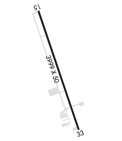
| Lat: N 3219.8 Long: W 09639.8 Elev: 500 Var: -03 Longest Runway: 4012 | ||
| CTAF: 122.9 | ||
| ||||||
|
| Rwy | Rwy | |||||||
| 4012x50 | 4012' | 4012x50 | 3758' | |||||
| Runway ID | Single Wheel | Double Wheel | Double Tandem Wheel | Dual Double Wheel |
| 16/34 | 18,000 | N/A | N/A | N/A |
| These numbers are Advisory and are not limits. The Airport Manager should have more accurate Weight Limits | ||||
 Airport Diagram might not be current. | |
| Facility Name: | ENNIS MUNI |
| City Name: | ENNIS |
| County: | ELLIS |
| State abbrev: | TX |
| State Name: | TEXAS |
| Ownership: | PUBLICLY OWNED |
| Use: | OPEN TO THE PUBLIC |
| Owner's Name: | CITY OF ENNIS |
| Address: | 107 N SHERMAN ST, PO BOX 220 |
| ENNIS, TX 75119-0220 | |
| Owner's Phone: | 972-875-1234 |
| Manager's Name: | ANDREA WECKMUELLER-BEHRINGER; CITY/ARPT MGR. |
| Address: | 107 N SHERMAN ST, P O BOX 220 |
| ENNIS, TX 75119-0220 | |
| Phone: | 972-875-4279 |
| FAA Region: | SOUTHWEST |
| FAA Field Office: | TEX |
| Date | Sunrise | Sunset |
|---|---|---|
| 06/07/26 Sunday | 6:19 | 20:32 |
| 06/08/26 Monday | 6:19 | 20:32 |
| 06/09/26 Tuesday | 6:19 | 20:33 |
| 06/10/26 Wednesday | 6:19 | 20:33 |
| 06/11/26 Thursday | 6:19 | 20:33 |
| 06/12/26 Friday | 6:19 | 20:34 |
| 06/13/26 Saturday | 6:19 | 20:34 |
| 06/14/26 Sunday | 6:19 | 20:35 |
| 06/15/26 Monday | 6:19 | 20:35 |
| 06/16/26 Tuesday | 6:19 | 20:35 |
| 06/17/26 Wednesday | 6:19 | 20:36 |
| 06/18/26 Thursday | 6:20 | 20:36 |
| 06/19/26 Friday | 6:20 | 20:36 |
| 06/20/26 Saturday | 6:20 | 20:36 |
| Airport Attendance Schedule | MON-FRI 0800-1700 |
| Airport Status | OPERATIONAL (This Status can change at any time - please check NOTAMS) |
| Airport Lighting Schedule | ACTVT REIL RWY 16 & 34; PAPI RWY 16 & 34; MIRL RWY 16/34, PRESET LOW INTST - CTAF. |
| Airport Storage Available | Tie Downs |
| Extra Services Available | Parachute Jumping |
| Wind Indicator | YES - (lighted) |
| Control Tower | NO |
| CTAF Frequency | 122.900 |
| Unicom Frequency | |
| Rotating Beacon Color | WG |
| Segmented Circle | YES |
| Landing Fee | NO |
| Airport Inspected | STATE - performed by PRIVATE CONTRACT PERSONNEL |
| Inspection Date | 05/20/2025 |
| Type of Fuel Available | Grade 100LL, JET A (freeze point -40C); -10FUEL SELF SERVE. |
| Airframe Repair Service | MAJOR |
| Power Plant Repair Service | MAJOR |
| Latitude | N3219.8 |
| Longitude | W09639.8 (ESTIMATED) |
| Arpt Elevation | 500ft (SURVEYED) |
| Magnetic Variation | 03E |
| 2 miles W | of ENNIS |
| Traffic Pattern Altitude | |
| Sectional Chart | DALLAS-FT WORTH |
| Operations (Reported) | Yearly | Avg. Daily |
|---|---|---|
| General Aviation Transient | 0 | 0 |
| General Aviation Local | 0 | 0 |
| Air Taxi | 0 | 0 |
| Commerical | 0 | 0 |
| Commuter | 0 | 0 |
| Military | 0 | 0 |
| Aircraft based on Field | |
|---|---|
| General Aviation Singles | 0 |
| General Aviation Multi | 0 |
| Jet Aircraft | 0 |
| General Aviation Helicopters | 0 |
| Military Aircraft | 0 |
| Gliders | 0 |
| Ultralights | 0 |
| FSS on field | NO |
| FSS tie-in | FORT WORTH |
| FSS Phone | 1-800-WX-BRIEF |
| Who issues Notams | FTW |
| Notam D service at airport | YES |
| ARTCC Name | FORT WORTH |
| Airport Certification | |
| Aircraft Rescue & Firefighting Index | None |
| Airport of Entry | No |
| Custom Landing Rights | No |
| Joint Civil/Military | No |
| Military Landing rights | YES |
| NATIONAL PLAN OF INTEGRATED AIRPORT SYSTEMS (NPIAS) |
| GRANT AGREEMENTS UNDER FAAP/ADAP/AIP |
| ASSURANCES PURSUANT TO TITLE VI, CIVIL RIGHTS ACT OF 1964 |
| BIRDS ON AND INVOF ARPT. |
| FOR CD CTC LONE STAR APCH AT 972-615-2799. |
| RWY 16/3 4 SFC CRACKING, LOOSE STONES. |
Airport Communications & Frequencies:
| ||||||||||||
| Runway: 16 | Runway: 34 | ||
| Mag heading: | 158° | Mag heading: | 338° |
| Rwy Slope: | -.58% Down | Rwy Slope: | .58% Up |
| Approach: | Approach: | ||
| Pattern: | Right Traffic | Pattern: | Left Traffic |
| Markings: | BASIC | Markings: | BASIC |
| Marking Condition: | FAIR | Marking Condition: | FAIR |
| Arresting Dev: | Arresting Dev: | ||
| Lat & Long: | N3220.1 W09640.0 | Lat. & Long.: | N3219.5 W09639.7 |
| Elev: | 500.2 ft. MSL | Elev: | 477.0 ft. MSL |
| TCH: | 35 ft. AGL | TCH: | 35 ft. AGL |
| Visual Glide Path: | 3.00 degrees | Visual Glide Path: | 3.00 degrees |
| Displaced Threshold: | No | Displaced Threshold: | 254 feet |
| Touchdown Zone: | YES | Touchdown Zone: | YES |
| Touchdown Elev.: | 500.3 feet | Touchdown Elev.: | 494.0 feet |
| Visual Glide Slope: | 2-Light PAPI on LEFT side of Runway | Visual Glide Slope: | 2-Light PAPI on LEFT side of Runway |
| RVR Equipment: | RVR Equipment: | ||
| RVV Equipment: | NO | RVV Equipment: | NO |
| Approach Lights: | Approach Lights: | ||
| REIL: | YES | REIL: | YES |
| Centerline Lights: | NO | Centerline Lights: | NO |
| Touchdown lights: | NO | Touchdown lights: | NO |
| Runway Category: | Runway with a Visual Approach | Runway Category: | Runway with a Visual Approach |
| Declared Distances: | Declared Distances: | ||
| Obstructions: | GND | Obstructions: | PLINE |
| Marked: | NOT Marked/Lighted | Marked: | MARKED |
| Clearance slope: | Clearance slope: | 34:1; APCH SLOPE 25:1 TO DSPLCD THR OVR 15 FT BRUSH, 382 FT DSTC. | |
| Obstruction height: | 5 feet AGL | Obstruction height: | 27 feet AGL |
| Dist. from runway: | 201 feet | Dist. from runway: | 1125 feet |
| Centerline offset: | 86 left of centerline | Centerline offset: | |
| Comments: | RISING GROUND 0 TO 5 FT FROM 0-199 FT DSTC, 88 FT L. | Comments: | 20 FT BRUSH, 0-130 FT DSTC, ACRS APCH. |
Thanks for using FltPlan.com
all rights reserved © 1999-2026 by Flight Plan LLC
